Following a devastating start to the 2022 fire season, New Mexico residents are facing the challenging reality of wildfire recovery. A Hermit’s Peak/Calf Canyon flood warning map is available from Highlands University. Those affected by recent and ongoing fires can learn more by visiting the After Wildfire (afterwildfirenm.org) website. Mental health resources are also available from our last Wildfire Wednesdays post. Finally, refer to the bottom of this blog post for land restoration workshop opportunities happening now for landowners impacted by the Hermit’s Peak/Calf Canyon Fire.
Hello Coalition members and partners,
We hope you’re staying cool as the hot summer days fly by. This week we will be introducing an often-overlooked niche of land management: community forestry. This concept involves local communities as active participants in the stewardship of surrounding forested lands. It also helps build capacity to meet multiple objectives - reducing fire risk, improving forest health and habitat, and maintaining cultural and community vitality.
This week features information on:
Existing community forestry programs in the West
Forest Council initiatives in New Mexico
Opportunities to learn more about community forestry, other community-led initiatives, and funding for community forests
Past examples of how communities have come together for post-fire response and recovery
Take care and have a wonderful Wednesday,
Rachel
Existing Community Forestry Programs
How can we learn from the paths that others have already forged?
The exact configuration of community forestry initiatives - the land jurisdiction, leadership, and their objectives - can vary widely. Here are a few highlights from those who have led by example.
Mt. Adams Community Forest: A new model of forest ownership for the West

Land ownership in the vicinity of Mt. Adams Community Forest: image courtesy of Mt. Adams Resource Stewards
Established in 2011, Mt. Adams Community Forest is the State of Washington’s first nonprofit-owned working community forest. The project began with an opportunity and subsequent fundraising to purchase the 100-acre Glenwood Valley’s Mill Pond property with its productive forests, restoration opportunities, water, and recreation resources. A few years later, community members and friends of Mt. Adams Resource Stewards (MARS) rallied again to purchase an adjacent 285-acre block in the form of Pine Flats Forest, followed by additional acquisitions in 2020. While the group is looking continually looking for opportunities to grow the forest through future land acquisitions, their focus is on growing a locally meaningful model of conservation and stewardship.
In their words, “the Mt. Adams Community Forest strives to permanently protect high community- and conservation-value forests critical to the quality of life of [south-central Washington]. Management goals for community forest properties are centered around principles of land stewardship, community benefit, and healthy functioning ecosystems. Such goals recognize the value of sustainably managed forest resources as a renewable source of wood products and jobs, balanced with the provision of habitat for flora and fauna, and public access for recreation. Tradition is an important element of the Mt. Adams Community Forest vision, and activities such as fishing, hunting, and firewood gathering are provided for when possible.”

Pine Flats Tract: image courtesy of Mt. Adams Resource Stewards
While management of the forest is carried out by the nonprofit landowners, Mt. Adams Resource Stewards, community members provide guidance on management priorities through public listening sessions and direct recommendations from their community advisory committee.
Western Klamath Restoration Partnership
“The Western Klamath Restoration Partnership (WKRP) began in 2007, focusing on in-stream fish habitat restoration of the Middle Klamath River sub-basin. It became a 1.2-million-acre upslope restoration collaborative incorporating an “all lands” approach to address threats to people, property, cultural and natural resources at risk of high-intensity wildfire.” It has since grown in scope and size to include more partners, entire landscapes, and new objectives, but stays true to its original intent: to build trust and a shared vision for restoring fire resilience at the landscape scale.
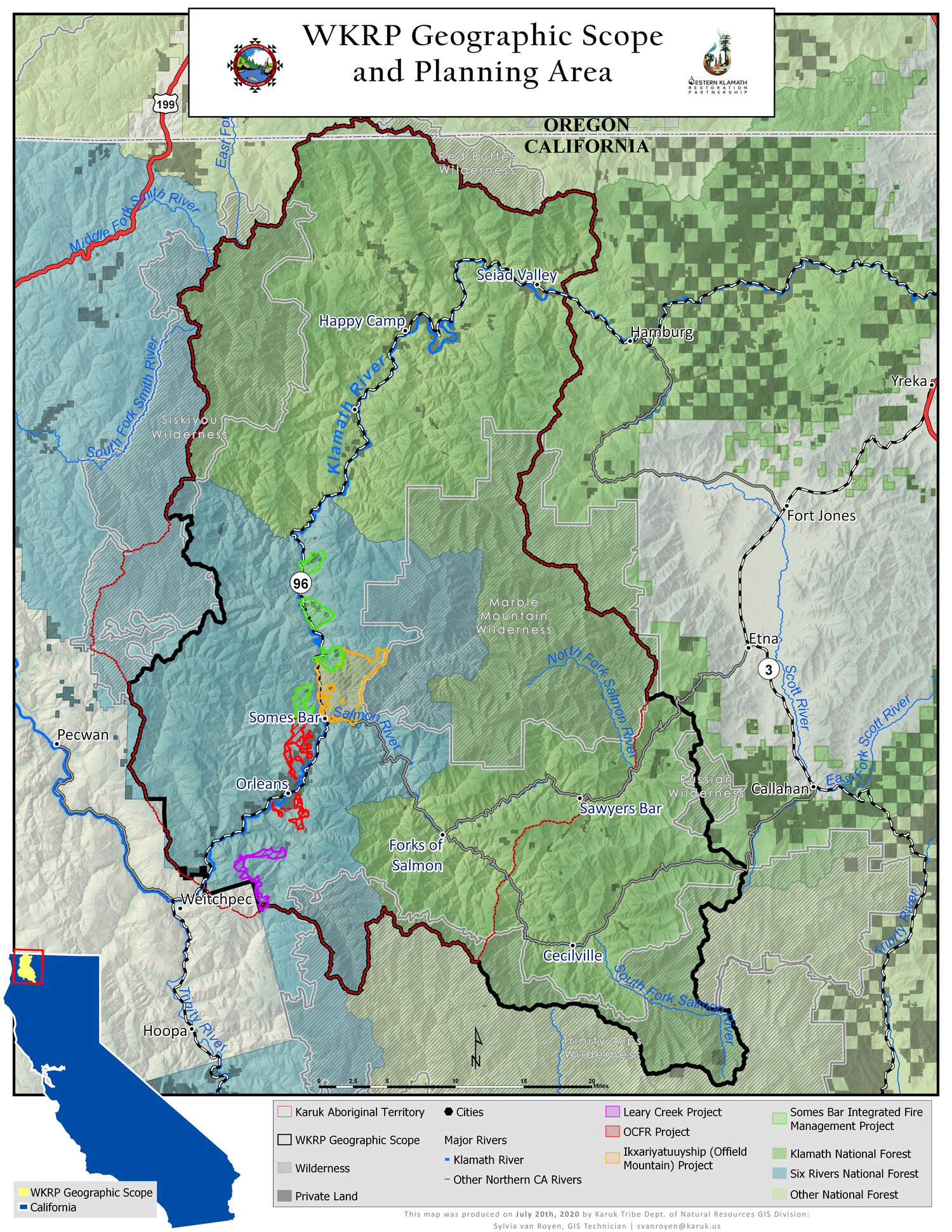
Geographic scope and planning area of the Western Klamath Restoration Partnership. Image courtesy of WKRP.
The WKRP is a unique project which began as a community-stewardship initiative and has expanded into a multidimensional collaborative of diverse stakeholders. Their trajectory offers many lessons learned, such as finding common ground through identification of Zones of Agreement (geographic areas where all parties agree upslope restoration needs to occur). Through honest dialogue using Open Standards Process for Conservation, they have been able to create a plan for restoring fire resilience at the landscape scale which is founded upon Traditional Ecological Knowledge (TEK) and practices and concepts outlined in the National Cohesive Wildland Fire Management Strategy.

Visualization of the Open Standards Process for Conservation. Image courtesy of the Western Klamath Restoration Partnership
A hallmark of the partnership “is the Karuk Tribe’s knowledge of fire, passed down from generation to generation. This ‘traditional ecological knowledge’ (TEK) shows us that traditional human/fire relationships of our past can guide the strategies of our future. Representatives from the Karuk Tribe, Mid Klamath Watershed Council, Salmon River Restoration Council, and the US Forest Service are co-leads of the collaborative group, but many other stakeholders, communities and organizations are involved.”
New Mexico Forest Councils
Forest Councils lay the groundwork for local residents to actively steward forested lands as a way to protect water, property and their way of life. While the Councils represent a broad and customizable organization structure, they consistently fill the role of providing governance and leadership for community-forestry efforts.
Cerro Negro Forest Council
A nonprofit entity led by representatives from five local organizations, “the Cerro Negro Forest Council represents residents of Valdez, San Cristobal and Gallina Canyon in their efforts to improve forest health and prevent devastating wildfires in parts of Taos County, New Mexico… The council has adopted the principles of acequia water management and are applying those principles to community-led forestry as a way for locals to generate an income from wood products while improving the health of their forests and watersheds.” Established in 2018, the Forest Council structure is modeled after a community-based forest stewardship program which ran for many years out of the U.S. Forest Service - Camino Real Ranger District.
Cerro Negro puts this model of community-led stewardship into action through implementation of their Forest Mayordomo Collaborative Forest Restoration Program project. Local woodcutters, or leñeros, are assigned and made responsible for thinning of small forested blocks on federal land. In return they receive a per-acre work stipend and can harvest all woody material they cut. This work is carried out under the supervision of the Forest Council’s mayordomo and asistante to ensure that treatments comply with the rules and regulations of the U.S. Forest Service.
Rio de Las Trampas Forest Council
Modeled after the successful Cerro Negro Forest Council and brought back home to the Camino Real Ranger District, Rio de Las Trampas Forest Council’s mission is “to foster collaboration and community involvement in forest and watershed health projects through the implementation and administration of stewardship agreements.” Their work is driven by the understanding that climate change, intense wildfires, unnaturally dense forests, and drought threaten the lands that support their communities.

A wood pile in El Valle gathered through the original USFS community forestry program which led to the creation of the Forest Councils. Photo by Kay Mathews.
The Council knows that “it is possible and replicable to partner with federal land managers to accomplish thinning objectives and reduce wildfire risk while providing a maximum benefit to local residents” and puts this knowledge into practice through their 2019 CFRP Supporting the Rio de Las Trampas Forest Council’s Leñero Program. This project replicates Cerro Negro’s Forest Mayordomo CFRP by training, educating, and paying local leñeros to thin and treat acres of federal land. In the end, this project aims to “provide fuelwood to the community, achieve forest thinning goals, and offer local residents the opportunity to care for the land”.
Read more about the Rio de Las Trampas Forest Council’s mission and model of community forestry.
Learning Opportunities
Deep-dive into the world of community forestry!

Photo by Scott Ishimara, copyright.
Empowering Community-led Forest Stewardship webinar on July 28, led by The Nature Conservancy, New Mexico. Healthy forests and wood products are essential to sustaining our communities and traditional use practices in New Mexico, but access to forests has been inhibited by multiple barriers. To address those challenges and discuss opportunities, The Nature Conservancy is hosting a free virtual event, generously supported by the Taos Ski Valley Foundation.
Get funded through the USDA’s Community Forest Program
“The Community Forest Program (CFP) is a competitive grant program that provides financial assistance to tribal entities, local governments, and qualified conservation non-profit organizations to acquire and establish community forests that provide community benefits. Community benefits include economic benefits through active forest management, clean water, wildlife habitat, educational opportunities, and public access for recreation.”
This program funds establishment of private forest lands for community use which meet certain qualifications. Mt. Adams Community Forest, the program highlighted in the first section of this newsletter, is funded in part by the CFP!
Learn about the community’s role in stewarding our urban forests
The New Mexico Energy, Minerals, and Natural Resources Department runs and Urban and Community Forestry Program to help communities develop and sustain healthy urban forests.

Image courtesy of NM EMNRD
They expand the definition of community forests to include all trees, vegetation, and associated natural resources within and around an inhabited area. Community trees include park trees, trees along streets and neighborhoods, and any trees within the wildland-urban interface between communities and adjacent forestlands.
The services offered by the Urban and Community Forestry are borne of the understanding that urban forests deliver tremendous value to communities and the people that live there. Trees contribute to reduced storm water runoff, improved air and water quality, increased property values, improved quality of life for citizens, increased economic development opportunities, and reduced energy use at homes and businesses.
Post-fire Community Response and Recovery
How can the community come together following a wildfire?
As a community, the other side of fire preparedness is how we come back together to respond to, recover from, and maintain our culture and traditions following a fire.
Learn about one Tribe's collaborative journey to develop forest resiliency and how Santa Clara Pueblo Forestry has been able to incorporate lessons learned from past wildfires into new Fire and Forest Management Plans to keep fire an active component in maintaining the landscape.
One takeaway from Santa Clara Pueblo’s experiences is that adapting to wildfire needs to happen both before and after the fire. Lindsey Quam and Gabe Kohler took that to heart and offer low-cost strategies for flooding and erosion mitigation is this 2019 FACNM article. These methods were part of a landscape-scale effort to mitigate flooding and erosion after the 2011 Los Conchas fire but are powerful tools for response and recovery that can be used to leverage the people-power in any community and make an impact against flooding and erosion before it occurs.
For landowners impacted by the Hermit’s Peak/Calf Canyon Fire, Luna Community College and the Forest and Watershed Restoration Institute (FWRI) are offering a free workshop series on land restoration techniques, happening now. The workshops will cover:
Reading the landscape and assessing post-fire damage, risks, and hazards
How to use burn severity maps to assess your land’s vulnerability to flooding
Post-fire forest thinning
Adapting road and culverts for post-fire flood mitigation
Erosion control with log structures, wattles, mulch and soil amendments
One-rock dams and arroyo restoration
Trash and debris racks
Contour felling and upland restoration for erosion prevention
Seed mixes and tree/shrub planting
Basic principles in monitoring the effects of post-fire restoration
July 23-24 (Saturday-Sunday): erosion control community service project in San Ignacio with the Albuquerque Wildlife Federation.
July 25-28 (Mon-Tues, Wed-Thurs): contour felling (2 days in Las Dispensas, San Geronimo), seeding (1 day in San Geronimo), and possibly discussing biochar (1 day)
August 4-7 (Thurs-Fri, Sat-Sun): post-fire forest thinning (two 2-day workshops)
You may sign up at luna.edu or show up at the designated meeting areas on the day of the workshops. For assistance, contact Karen Wezwick at 505-454-5308 or via e-mail at kwezwick@luna.edu.

Image courtesy of AfterWildfireNM.org