Following a devastating start to the 2022 fire season, New Mexico residents are facing the challenging reality of wildfire recovery. A Hermit’s Peak/Calf Canyon flood warning map is available from Highlands University. Those affected by recent and ongoing fires can learn more by visiting the After Wildfire (afterwildfirenm.org) website. Mental health resources are also available from our last Wildfire Wednesdays post. Finally, keep an eye out on the FACNM website for information about an upcoming post-fire community resources expo in Northern NM.
Take care and stay safe.
Happy Wednesday, FACNM Community!
As the climate changes, gathering precise and local weather data can help us understand how it is impacting the arid Southwest in real time. Weather monitoring station data, from community science efforts to a permanent technical network across the county, can inform weather predictions and future climate trends.
Today’s Wildfire Wednesday features:
Weather station basics - what are they and why do they matter?
How the data is used and how you can help
Upcoming events
Best wishes,
Rachel
Weather station basics
What are weather stations and why do we need them?
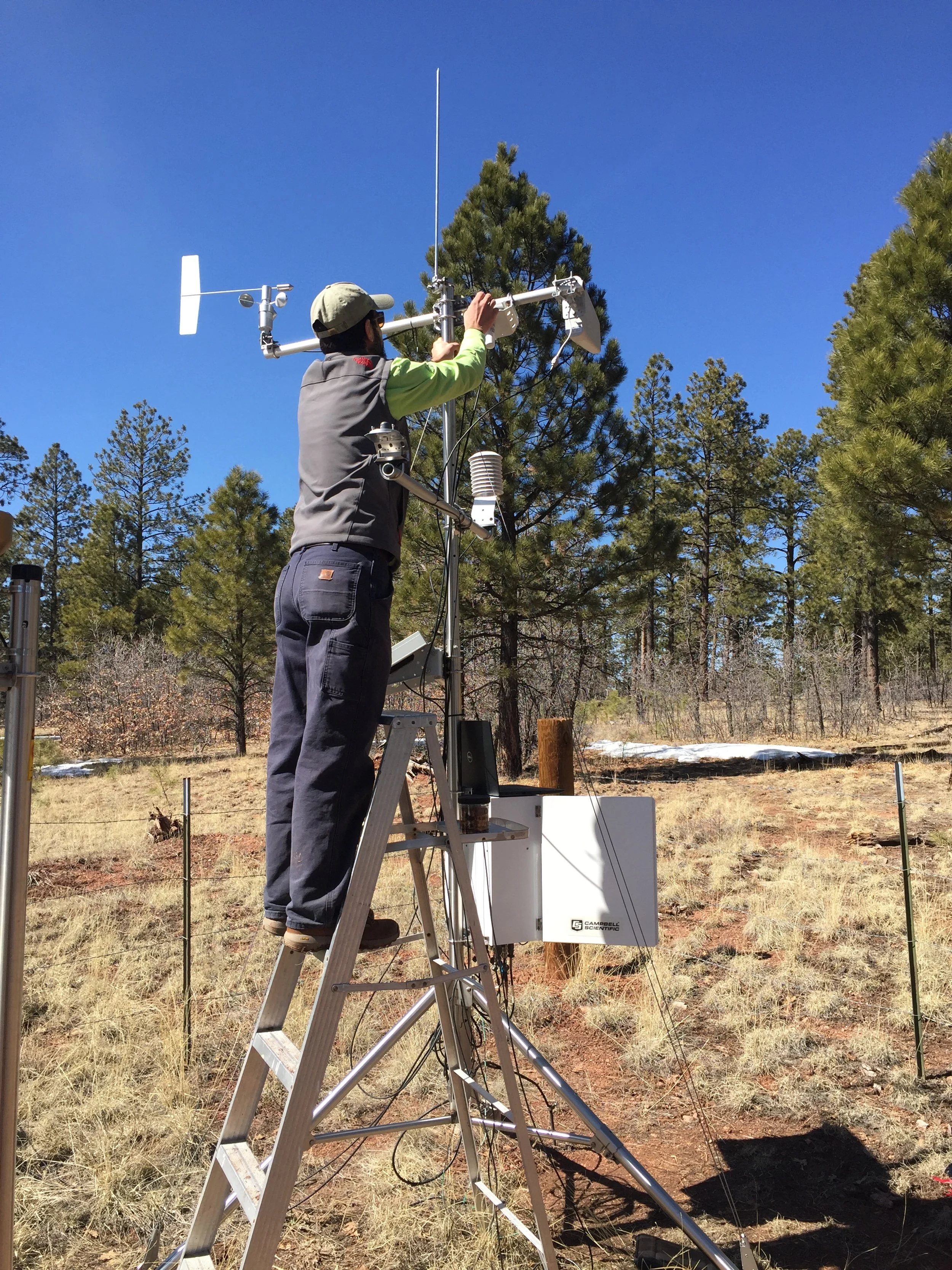
Together with satellites, weather buoys, meteorological probes, and radars, weather stations, or meteorological stations, are primary facilities for weather observation and collection of different weather data. These facilities contain instruments and equipment for measuring atmospheric conditions such as temperature, atmospheric pressure, humidity, wind speed, wind direction, and precipitation amounts. Weather stations measure conditions at a single geographic location and send these data to processing or collection centers. Together, atmospheric measurement data from a network of weather stations inform our weather forecasts and allow us to study the weather and climate. Most weather stations today are automated and may transmit data daily or hourly.
Types of weather stations
Professional vs Home or Amateur Weather Stations

NASA Dryden meteorologists prepare to launch a weather balloon next to a Sonic Detection And Ranging wind profiling unit. Photo: NASA Dryden / Tom Tshida
Professional, or synoptic, weather stations must meet international meteorological standards and pass the accuracy requirements of the National Institute of Standards and Technology. These facilities collect the most complete meteorological data and are often part of the World Meteorological Organization station network.
Amateur weather stations collect the same basic weather data - air temperature, wind speed and wind chill, humidity, atmospheric pressure, and more - but in general the data are less complete compared to professional weather stations. Many amateur stations contribute to global weather station networks and their data can be exchanged online through cooperative databases such as MesoWest. The Citizen Weather Observer Program (CWOP) also facilitates the sharing of information from personal weather stations. These data are utilized by groups such as the National Weather Service (NWS) and Weather Underground when generating forecast models.
Learn more about the differences here.
Remote Automatic Weather Stations (RAWS)
Data from a RAWS station installed in the Zuni Mountains of western NM is transmitted to MesoWest.
RAWS are self-contained portable or permanent solar-powered weather stations that provide timely local weather data. According to the National Interagency Fire Center, “there are nearly 2,200 interagency RAWS strategically located throughout the United States. These stations monitor the weather and provide weather data [used for] projects such as monitoring air quality, rating fire danger, and providing information for research applications… RAWS units collect, store, and forward data to a computer system at the National Interagency Fire Center (NIFC) in Boise, Idaho, via the Geostationary Operational Environmental Satellite (GOES), operated by the National Oceanic and Atmospheric Administration (NOAA).”
NOAA and the National Science Foundation (NSF) also support other group-source and citizen science weather data collection initiatives such as the Community Collaborative Rain, Hail and Snow (CoCoRaHS). Learn more about this network below in How to get involved.
How weather stations influence science and safety
Improved weather forecasting for improved fire outcomes

NOAA and the NWS provide daily weather forecasts through their Weather Prediction Center.
According to the National Weather Service, “[Professional] forecasters build their forecasts with observations from surface stations, weather balloon readings, and satellite data that feed numerical weather, water, and climate models whose output is analyzed and scrutinized using individual scientific expertise. Forecasters communicate this information and potential impacts to the public, emergency managers, and other core partners to help make decisions that save lives and protect property.” Weather monitoring data may also feed into automated weather forecasts which are used by fire personnel, land managers, and others involved in prescribed and wildland fire to better understand the conditions on the ground. “Fire managers use weather station data to predict fire behavior and monitor fuels; resource managers use the data to monitor environmental conditions” (NIFC).
When writing a burn plan, fire managers pull data from multiple RAWS stations to estimate 99% weather conditions for the site. This means that actual weather conditions will vary from the predicted model less than 1% of the hours in a year. Fire managers base their fire behavior models and burn parameters, in part, on these anticipated weather conditions. Having accurate local weather is also imperative for tracking localized trends and changes in weather conditions. For this reason, fire managers may utilize a mobile weather monitoring station or order a spot forecast from the NWS to gather meteorological data at the exact location of their prescribed burn or wildfire.
Learn more about the science and art of fire weather and how it is used to predict fire behavior.
Evaluating the impact of climate change

Modeled temperature change under future climate scenarios from the U.S. Global Change Research Program’s National Climate Assessment.
“To make weather forecast predictions, meteorologists use weather data and forecast models to determine current and future atmospheric conditions. Because weather takes place hour by hour, forecast models use current atmospheric and oceanic conditions to predict future weather” (from Columbia Climate School). “Climate models are [essentially] an extension of weather forecasting… but [instead of making] predictions over specific areas and short timespans, climate models are broader and analyze long timespans. They predict how average conditions will change in a region over the coming decades.” Nuanced and accurate weather data informs our understanding of current conditions and also allows us a greater understanding of how weather conditions are changing over time, both in the datasets and when compared to historical ranges. With real-time localized data, weather monitoring stations allow us to analyze trends in precipitation, temperature, and other climatic conditions which play a role in evaluating the impact of climate change.
How to get involved

Image courtesy of Iowa State University
Interested in becoming a citizen scientist and helping to track local weather trends? A recent environment story by NM Political Report encouraged individuals to “participate in the Community Collaborative Rain, Hail and Snow Network, better known as CoCoRaHS. For a small fee to purchase equipment, which runs around $40, individuals can set up a weather station at their house that will provide valuable information to researchers.”
Upcoming events
Webinars
July 19, 2022 at 12pm MDT: Wildfire, Smoke Exposure, Human Health, and Environmental Justice Need to be Integrated into Forest Restoration and Management - Southwest Fire Science Consortium