Forest Health, Pests, Disease, and Fire: A Primer on the Current Tussock Fir Outbreak

New Mexico’s forests are facing growing challenges from insects and disease, and the impacts are becoming increasingly visible across the landscape.

In recent years, hotter and drier conditions have created the perfect environment for widespread outbreaks, leaving many residents concerned about the health of the trees that surround their communities. According to New Mexico’s 2024 Forest Health Summary, The total number of forest and woodlands mapped in 2024 with damage from insects, disease and abiotic conditions was 406,000 acres on all landownership types in New Mexico, an increase of 42,000 acres or 12% since 2023.”

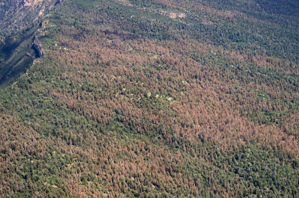
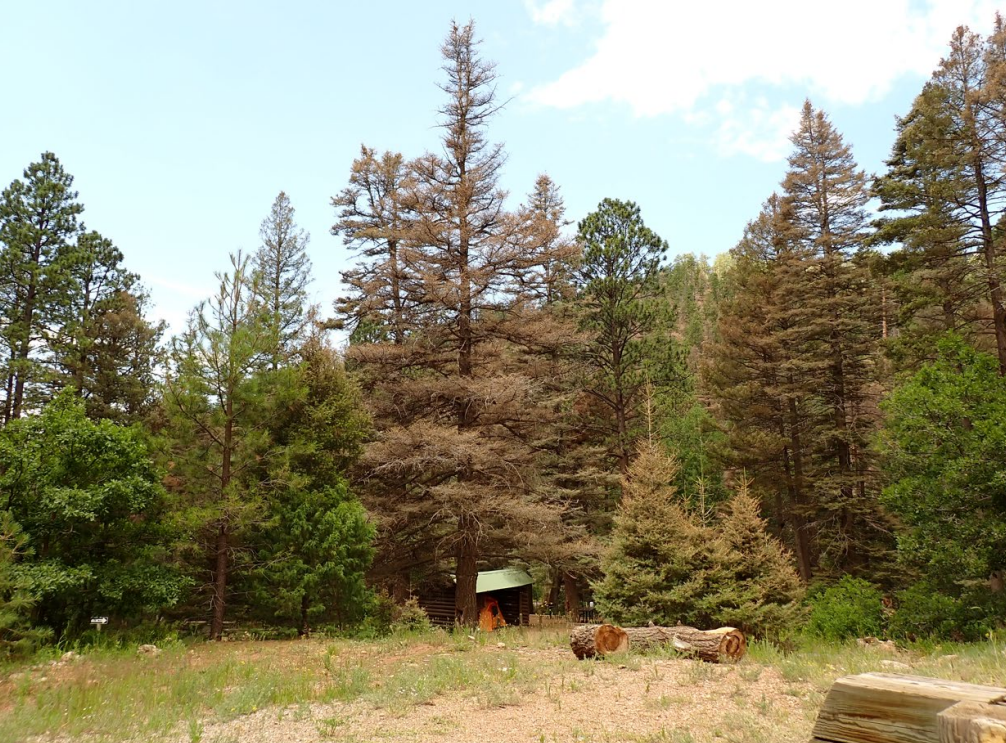
This year, northern New Mexico residents have noticed large patches of trees turning brown, raising alarm about what’s happening in the forests. Much of this damage is linked to the insect activity.

The relationship between insects, drought, and wildfire is an ongoing cycle. Hotter temperatures and reduced precipitation weaken trees, making them more susceptible to insect attack. In turn, beetle-killed or disease-weakened trees create more dead and susceptible fuel for future wildfires. By looking closer at how insects and fire interact, we can better prepare for the challenges ahead and explore strategies to make our forests more resilient.

Below you will find information about:

Stay safe and be well,
Megan


A Primer on Tussock Fir Outbreaks


Summary of today’s primer:

History - High-elevation forests across New Mexico have experienced a tussock moth outbreak over the past three years which has left many trees, primarily Douglas fir and White fir, with damaged orange crowns and has caused some mortality.

Takeaways - The Douglas-fir tussock moth is just one of many insects and diseases impacting forest health across the state. Although the current tussock moth epidemic is waning in many places, forests across New Mexico continue to face growing pressures from bark beetles, defoliating moths, engraver beetles, and other pests and pathogens. These disturbances weaken individual trees and can trigger large-scale mortality events. As the climate becomes hotter and drier, and forests experience greater water and resource stress, pest and disease activity is intensifying. The resulting tree death reshapes landscapes in different ways depending on forest type.

Next steps - Targeted, ecologically sound thinning remains one of the most effective tools for strengthening forest resilience, both against insects and disease, and against wildfire.

………………………………


The basics of defoliation

The following is based on a presentation from Victor Lucero. For more information, visit the Forest Health website or contact Victor.

Why do all those trees look dead?

An outbreak of a native insect called the Douglas-fir tussock moth (DFTM) has defoliated trees – meaning, damaged the leaves of trees – in and around the Santa Fe National Forest. The three-year outbreak has likely just ended, according to Victor Lucero, Forest Health Program Manager for the New Mexico Forestry Division. In late August 2025, the Greater Santa Fe Fireshed Coalition Ambassadors invited Lucero to talk about the insect, what caused its outbreak, and how the outbreak has impacted forest health. 

What is the Douglas-fir tussock moth? 

The Douglas-fir tussock moth is endemic to western North America: It belongs here, it will always be here, and it’s always present in the forest.  

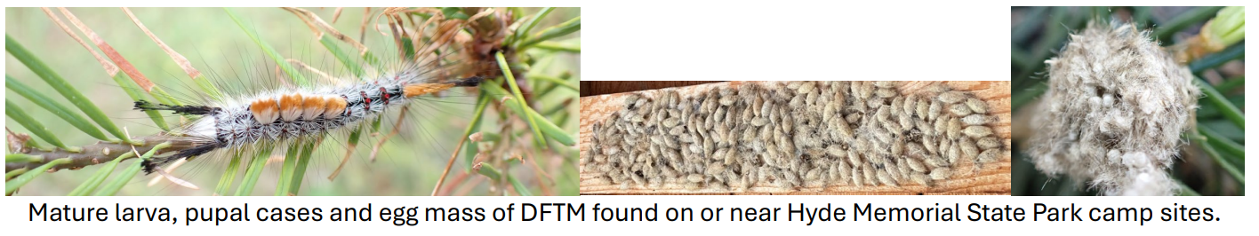
The Douglas-fir tussock moth overwinters in an egg mass that contains a few hundred eggs. In the spring, those eggs hatch into the first instar caterpillars (the first stage of development), which disperse by “ballooning” – so wherever the egg masses are, the insect will disburse through wind currents or thermals. The emergence of this first instar coincides with bud burst (the emergence of new growth on trees). Near Santa Fe, that has been around the middle of May for the last couple of years. The insect then begins to develop into larger caterpillars and finally reach a stage of caterpillar that resembles the photo below. Tussock moths generally pupate in late summer, forming cocoons from which they emerge as moths.

This insect is a strict defoliator, meaning that it feeds on the needles of trees; it does not feed on buds, it does not burrow into trees, it does not kill trees by girdling the tree stems. As the name suggests, Douglas fir is one of the hosts, but the tussock moth can also attack other trees such as spruce and true firs. 

Douglas-fir tussock moths are defoliators. Does that mean they’re killing trees? 

The affected trees, especially visible with their reddish-brown needles, are in different stages of defoliation. Many of them will die, and many of them will not. 

Seeing the discolored tree canopies leads a lot of folks to wonder why the trees are dying. This has led to a lot of commentary, a lot of concern, and rightfully so; nobody wants to see the forest going from green to this. However, these needles are just responding to either one single bite or multiple bites from caterpillars.

So what is actually happening to the trees, post-defoliation? When we look closely, the buds of many impacted trees are, even now, starting to open. Defoliation stresses trees, but won’t necessarily kill them unless they are hit multiple years in a row. Victor Lucero has observed trees that are 80% defoliated, and the following year they break bud and are fine, given no other defoliation event by Douglas-fir tussock moth or another insect. That said, there will be some mortality. Driving through the forest, you’ll see some gray, dead trees; those will not come back, and those can be potential wildfire hazards. 


What is the cause and extent?

What caused this outbreak in New Mexico? 

It's important to note that whenever there's an outbreak of an insect, it usually is triggered by something else.  In this case, there is a problem with too many trees per unit area (the forests are too dense) in many woodlands and forests. The reality is that this insect is responding to an abundance of food.  

The Douglas-fir tussock moth has a high rate of mortality early after hatching because of either starvation or predation, but more so when needles aren't readily available. Our dense forests provide a veritable buffet table for the moths and provide a safe place for them to mate and lay their eggs, continuing the cycle. It’s common for Victor to count 50 trees in a 20-foot by 20-foot area, and that's just not sustainable for the viability of the tree or for the health of the entire forest.  

The Douglas-fir tussock moth has been attacking white fir because it is extremely overstocked in our high-elevation and northern forests. Fire, which we have long been unnaturally suppressing, belongs in our forests because it reduces the amount of fuel (flammable material) on the forest floor and keeps certain species of trees at levels that were historically documented. For white fir, historically, there were notably fewer trees per acre and were less widespread than they are now. The high density of a tree like white fir is supporting a very large population of the tussock moth which in turn is reaching the point of an outbreak wherever we see high densities of white fir. 

How do we know how bad the outbreak is?

One way we monitor and track tussock moth activity is through pheromone traps. The traps have a lure and are coated with sticky glue impregnated with a sex pheromone to attract male moths (the females do not have wings and are not mobile). This acts as an early detection system – if we catch 25 male moths on average at a five-trap site, that triggers us to then go and subsequently count for egg masses.

Last year, in an area of Hyde Park (near Santa Fe Ski Basin), there were 300-400 egg masses in 29 trees. That’s a breaking point. Victor recently monitored six different sites in northern NM, from Black Canyon to the Aspen Ranch, and didn't find a single egg mass. 

Is the outbreak over? 

There are naturally occurring predators and parasitoids, mostly wasps and fly species, that affect tussock fir populations and keep them in check, but more importantly there is something called a nuclear polyhedrosis virus, NPV. It occurs naturally in the environment, and when caterpillars of the Douglas-fir tussock moth come in contact with that virus, they begin to wilt, like a dangling ornament on a tree.  

When a caterpillar gets infected with this virus, the virus quickly reproduces and then causes the caterpillar to rupture. When this happens, it releases millions of viral particles per caterpillar which then spreads to and infects other caterpillars. Around the third year of a tussock moth outbreak, the viral load becomes widespread enough that the population collapses. 

Typically, an outbreak lasts three, maybe four years. In northern NM, we're at the end of the third year and we’re seeing that population collapse happening.

Why are there signs instructing people “DO NOT TOUCH” the Douglas-fir tussock moth? 

There have been multiple incidents over the last couple of years of people experiencing tussockosis. This is an affliction where tufts of very small, compressed hairs on the Douglas-fir tussock moth come into contact with someone’s skin and cause irritation, especially among people who are predisposed to allergic reactions.


What’s next, and what can be done?

What should we expect to happen next? 

Victor and state Forestry Division will continue to monitor tussock moth activity. Based on rudimentary sampling, it looks like the Douglas-fir tussock moth population has collapsed and now it’s a matter of determining how much tree mortality has occurred. Land managers will then have to decide what to do about the standing dead trees. Monitoring will also continue because there is a potential for bark beetles, like fir engraver beetles, to come in and attack these weakened defoliated trees. Knowing how much insect activity is happening in these defoliation sites allows Forestry Division to give a better assessment as to the overall health of the trees.

Bark beetles attack stressed trees – and they’re outright tree killers. Male bark beetles colonize the trees, emit a sex pheromone to draw in females, and eggs hatch into grubs which feed on the phloem - the phloem is what transports water and nutrients between the roots and leaves. The beetles also introduce a staining fungus, blue-stain fungus.  

All of this is happening underneath the bark where we don’t see the damage. Often, the first sign of a beetle outbreak is the tree canopy turning an orange color, called fading. The feeding action that girdles the stem and the introduction of the staining fungus very quickly leads to mortality.

Bark beetles have been here, they’ll continue to be here, and they will typically target stressed trees because they’re easier to colonize: If trees are doing well, there's a sustained sap flow, and the system is under pressure so a bark beetle trying to attack it will literally be pitched (pushed) out because of the resiliency of the host.  

However, if there's a beetle outbreak that is triggered by a big tussock moth defoliation event, the numbers of bark beetles can increase dramatically, disperse widely, and overcome even healthy trees. That’s where things can become very problematic, where you have outbreaks of bark beetles that continue for several years. For now, Victor hasn’t seen a whole lot of bark beetles in the areas near Santa Fe that have been hit by defoliation.

What can be done to help the forest?

Wherever we see thinning treatments, those trees have less competition, but where we have high densities of trees, there’s a lot of competition going on. Where densities of trees remain unnaturally high, the data collected on the Douglas-fir tussock moth over multiple decades shows that every ~7 to 10 years, we can expect to see another outbreak of Douglas-fir tussock moth like this, which will last 3-4 years. These insects are capitalizing on the abundance of food: where the trees are canopy-to-canopy and there are lots of them, it’s easy for these animals to disperse from one tree to the next. The best thing we can do is continue to thin the forest in a targeted and ecologically-sound way to improve its resilience to pests, something which also improves its resilience to wildfire.


Pests and Fire

How defoliation and insect-driven mortality impacts wildfire susceptibility

A western USA coniferous forest landscape where BDAs are a common and natural feature. BDAs interact with abiotic factors such as fire and drought to determine forest composition and structure at stand and landscape scales.

A common belief is that forests infested by insects, pathogens, and parasitic plants, also known as biological disturbance agents, or BDAs, are “unhealthy” and are, therefore, at greater risk of fire. However, more recent research indicates that BDAs often have a more nuanced, context-dependent influence on fire. Collaborative research, funded by the U.S. Environmental Protection Agency, U.S. Forest Service and Oregon State University, is described in the article, “The complexity of biological disturbance agents, fuels heterogeneity, and fire in coniferous forests of the western United States.” This manuscript provides a conceptual framework for how to relate BDAs, fuels and fire based on a review of supporting literature.

Main takeaways from the review:

  • BDAs include diverse biota, including native and non-native pathogens, insects, and parasitic plants, which both respond to and reshape forest composition and structure by causing tree decline and mortality and changing species composition.

  • BDAs impacts on fuels, and thus on fire likelihood, behavior, and severity, depend on the timing, scale, and extent of outbreaks, as well as preexisting stand conditions.

  • Most BDA groups have received little attention from fire researchers, despite many being pervasive across the western United States. The role of BDAs in shaping fuel characteristics and fire risk is very relevant under today’s warming and drying climate.

  • The way BDAs interact with fire depends primarily on how significantly BDAs influence canopy, surface, and litter/duff fuels.

  • BDAs influence fuel structure in live crowns by killing leaves, branches, and whole trees, they cause species-specific tree mortality, and affect competitive interactions among tree species, all of which modify canopy, surface, and litter and duff fuels, which also vary with time.

  • Dead canopy biomass eventually moves to the forest floor and understory, increasing surface and ground fuels, decreasing canopy fuels and affecting microclimate at the scale of the mortality or defoliation. The influence of BDAs on horizontal and vertical patterns of fuels is complicated by the magnitude of mortality, as well as the structure and composition of the stand before and subsequent to BDA events. In general, surface fuels increase, and canopy fuels decrease, while litter and duff may increase associated with the conversion of aboveground live biomass to dead biomass.

  • The role of BDAs in increasing active crown fire is when the temporal aspect of the outbreak is at its peak of intensive tree mortality and there are many trees with dead (green foliage can be dead and dry) and red foliage. Fires in systems in the red phase can have higher fire intensity, faster rate of spread, lower crowning thresholds, greater consumption of fine dead branches, and more crown fire than predicted by fire behavior models. However, the potential for active crown fire decreases after snags fall due to lower canopy connectivity and canopy bulk density, as well as conversion to surface fuels that do not play a large role in fire spread.

  • Although BDAs may increase fire severity in some stands during some time periods, heterogeneity in fuels created by BDAs can increase diversity in fire severity by reducing homogeneity in forest conditions and fuels that support larger patches of high-severity fire.


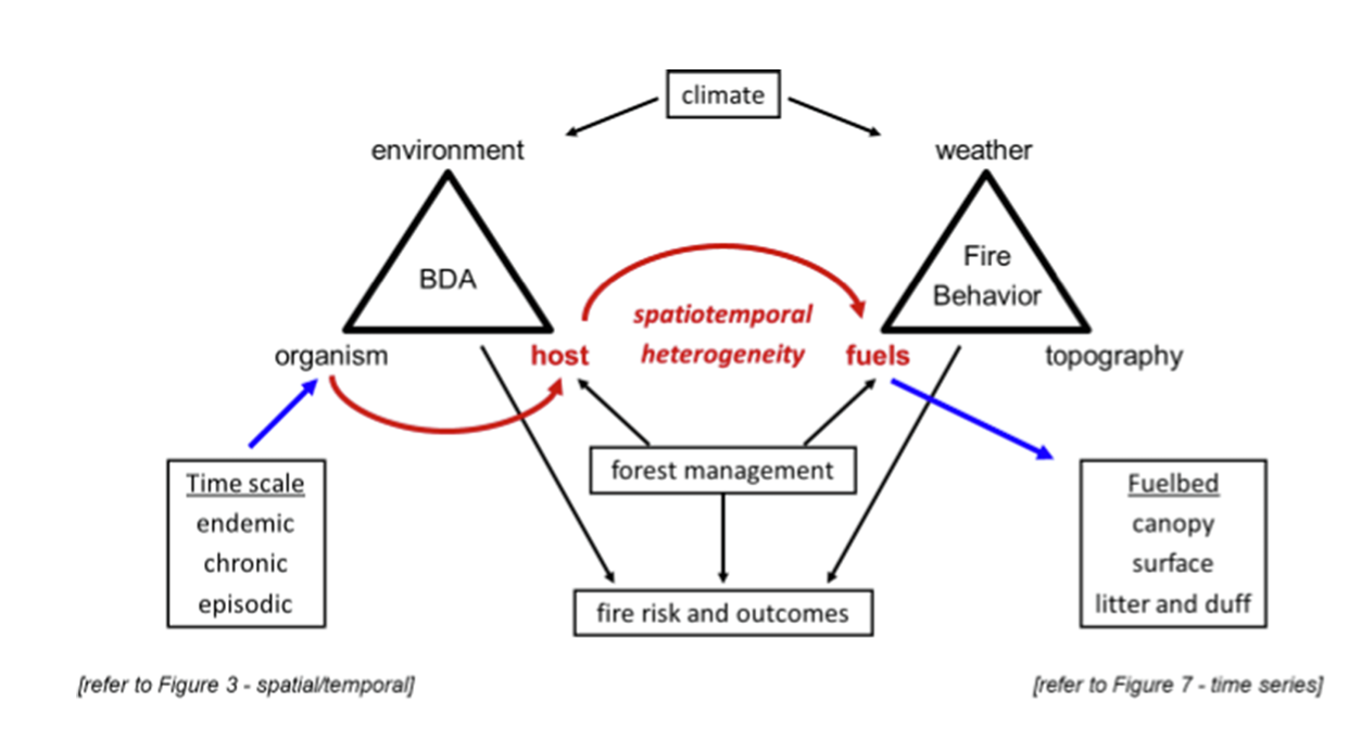
A conceptual framework of the influence of BDAs on fuels and fire behavior and the relationships among associated factors. Together, with forest management and weather, BDAs influence the spatial heterogeneity of fuels and associated fire risk and outcomes.


Although BDAs may elevate fire risk in some stands or time periods, their influence is variable. A useful way to understand their role is to distinguish between outbreaks that cause rapid tree mortality and chronic agents that slowly drive decline. This framing highlights how BDAs shift live fuels to dead fuels, alter moisture and chemistry, and redistribute fuels across canopy, surface, and ground layers over short- and long-term timescales. Ultimately, the effects of BDAs on fire cannot be generalized. They depend on the type of BDA, the structure and composition of the forest, and the spatial and temporal patterns of disturbance.

Wildfire Wednesdays #168: Updates on Cultural Forest Practices and Fire Adaptation

Happy Fire Friday, Santa Fe Fireshed community!

For this newsletter topic, we wanted to share an update to some information we provided back in 2021 related to cultural forest practices and the complex relationship humans have had with forest management for millennia. It is a common misconception that that the American West was “shaped entirely by natural forces” prior to arrival of Europeans; however, burning and logging have played a significant role across our landscape for nearly 15,000 years. Read on to learn more about these forest management techniques and the indigenous peoples who practice them today.

We are also at the tail end of Source Water Protection Week here in Santa Fe! Below we share some resources to learn more about what source water is and how a diverse set of partners are working to protect it.

This Wildfire Wednesday features:

Have a great start to autumn,
Rachel


Source Water Protection Week

The best way to assure we have high quality drinking water at the tap is to protect our beautiful water sources. If we keep our rivers, lakes and underground wells free from pollution, it’s easier and less expensive to keep water safe and healthy.

This year, Santa Fe Water is joining the American Water Works Association to celebrate Source Water Protection Week. Click on the links below or visit the Santa Fe Government Facebook page to learn about the water that comes from the mountains to sustain Santa Fe and the surrounding areas.


Cultural Burning


What is cultural burning?

Cultural burning by Native Americans interconnected them not only to the land but to their animal, reptile, bird and plant spiritual relatives. Therefore, conducting a cultural burn relates to what they burned, how they burned it, and why they burned it
— Ron W. Goode, Tribal Chair, North Fork Mono Tribe

Cultural burning falls within the broader category of intentional fire for community and resource resilience, a designation which also contains prescribed or controlled burns. “Cultural burning is separate and distinct from prescribed fire. While both forms of beneficial fire are essential to restoring good fire to the landscape, cultural fire has history, motivation, and meaning beyond the benefits it can reap for the environment” (Good Fire II, 2024).

Cultural burning is also a key component of traditional knowledge. “Reciprocity is a critical component of most Indigenous knowledge systems across the Tribes in the Columbia River Plateau, Intermountain West, and Great Basin and is one of the tenets of process-based restoration. Traditional knowledge systems convey principles of conduct for community members, pass down observations recorded through stories and songs, and describe the obligation to care for ecological systems as perpetual stewards” (An Indigenous Perspective of Fire, 2025). Within indigenous communities, cultural burning is “pertinent and substantial to the cultural livelihood”. Anthropologists have identified more than 70 different purposes for the intentional use of fire within ancestral indigenous and aboriginal cultures. There is also evidence that land areas used by Native Americans and subject to Indigenous fire management practices were more fire-resilient, even during climate periods that favored longer fire-free periods (NOAA, 2023).


History of cultural burning

Image by Stormy Staats, Karuk Women’s Indigenous Prescribed Fire Training Exchange via Good Fire II

State and federal government policies over the last 150+ years have targeted, banned, and put substantial logistical and legal strain on the use of cultural burning. “Sovereignty over lands, waters, and natural resources within their unique ancestral territories is one of the most critical retained powers for Tribes… Nevertheless, both federal and state governments can and do interfere with the exercise of such sovereignty” (Good Fire, 2021). Some barriers to cultural burning include:

  • Entities mistakenly treating cultural burning as prescribed fire (and therefore restricting it according to prescribed fire standards)

  • State and federal agencies asserting that they must “Permit” or “Allow” cultural burning on Lands of Territorial Affiliation.

  • The expertise of cultural fire practitioners in not formally recognized.

  • The enabling conditions necessary for landscape-scale, multi-jurisdictional stewardship are not yet in place (visit Good Fire II, page 13 for more detail).

In 2024, the Karuk Tribe championed, and the California Legislature passed, first-of-its-kind legislation that allows federally recognized tribes to practice cultural burning freely once they reach an agreement with the California Natural Resources Agency and local air quality officials. In February of this year, the Karuk Tribe became the first to enter into such an agreement. In this instance, that means that Cal Fire will no longer hold regulatory or oversight authority over the burns and will instead act as a partner and consultant, restoring the proper government-to-government relationship. There are still many barriers to indigenous communities exercising their sovereignty related to cultural burning, including some which are unique to the Southwest or have their roots in the complicated ‘trust responsibility’ of the Bureau of Indian Affairs. However, the successes by and lessons learned from our neighbors to the West can help us pave the way to wider use of this practice in New Mexico.

To learn more about cultural burning, visit the Indigenous Peoples Burning Network for more resources or watch this video by The Nature Conservancy “Revitalizing Cultural Burning practices, New Mexico and Beyond”.


Deep dive on cultural burning

Click on the buttons below to view academic papers and other articles detailing the history of cultural burning practices in the American West and current revitalization efforts. You can also register to attend an upcoming webinar from the Southwest Fire Science Consortium on the legacy of Indigenous cultural burning, showing that tree-ring fire history records from pine forests in Arizona and New Mexico demonstrate that Indigenous foragers, pastoralists, and farmers influenced Southwestern fire regimes.

Articles/Resources

SOUTHWEST INDIGENOUS FIRE STEWARDSHIP: An annotated bibliography of sources
AN INDIGENOUS PERSPECTIVE OF FIRE IN THE UPPER SNAKE RIVER BASIN
Cultural burning: Wildfires in the Arctic

Publications

Legacies of Indigenous land use shaped past wildfire regimes in the Basin-Plateau Region, USA
THE ROLE OF INDIGENOUS BURNING IN LAND MANAGEMENT
Native American fire management at an ancient wildland–urban interface in the Southwest United States

Events

Register for the 11/5/25 webinar
Takeaways from a 2024 discussion on restoring a culture of fire in NM
 

Cultural burning success stories

Indigenous Knowledges and Sciences as Best Available Scientific Information
Best Available Scientific Information (BASI) is defined as science that is accurate, reliable, and relevant. Indigenous Knowledges and Sciences (IKS) are place-based, culturally relevant knowledge that has been collected and carried down by Tribes and Indigenous Peoples from generation to generation. The wisdom contained within the broad scope of IKS is accurate, reliable, and relevant and is therefore qualified as BASI that can be used by land managers and researchers. Researchers and professionals need to recognize that the dimensions of specialization, personal experience, and transmission of IKS are diverse and complex, and understand that the information gathered by Indigenous Peoples is collected and communicated in different ways. Immense variation is present among Indigenous cultural roles, languages, and oral histories, as well as in methods of obtaining information. Ultimately, the findings obtained and documented through IKS belong to the people of that Indigenous Nation. These truths all need to be considered and respected when engaging with IKS as BASI.

Read More about IKS as BASI

The following story comes from an April 2025 article, Bringing ‘Good Fire’ Back to the Land

The Yocha Dehe Wintun Nation has recently revived its tradition of cultural burns. Every fall, the tribe holds Leok Po days, which means “good fire,” on Yocha Dehetribal lands in the Cache Creek Nature Preserve in Northern California. Melinda Adams, San Carlos Apache Tribe member and geography and atmospheric science professor at the University of Kansas, has come to help. She ties tule stalks into forearm-length bundles, preparing them as fire-carrying torches: “It’s significant,” she says, “because it’s one of the plants tribes use historically.” She calls these practices “indigenuity — Indigenous genius.”

Image courtesy of Cache Creek Conservancy

Adams experiences the ceremony as deeply restorative — not just for the land but for herself, her community and her connection with her ancestors. “We’re not just healing the land ecologically and doing good stewardship work that’s eventually going to regenerate the plant communities,” she says. “We’re also healing ourselves as people, relearning our ways.”

For her, reviving cultural burns is also a reclamation and cultural revitalization. Every cultural fire practitioner she knows works with Native youth. “Whether we document it or not, we all make sure these cultural lessons are passed on to the next generation,” she says. “For a long time, it wasn’t safe to be Native. But cultural fire is a way of returning to the landscapes we were once punished for stewarding. When we gather for a burn, we reclaim our place.”

Read the full article from yocha dehe

………………………….

In 2021, we published a story from the Mono Tribe on how cultural burning is being practiced and what lessons it holds for the future of the forest (see video). California banned cultural burning back in 1850 as part of legislation designed to forcibly remove Indigenous people from their ancestral lands. In an update to that story, this article explores how, since the California ban was lifted in 2022, the Tule River Indian, North Fork Mono, and Tübatulabal Tribes are working to return fire to Giant Sequoia groves. While only two off-reservation cultural burns have taken place in the giant sequoia range, the tribes and their partners are hopeful that these first steps will build widespread support for cultural burning. Click here to read the article “Banned for 100 years, cultural burns could save sequoias”.

………………………….

Members of the Washoe Tribe of Nevada and California burn piles in an overgrown area near Dresslerville, Nev., to promote new willow growth, a key resource for traditional basket making.
Image courtesy of The Washoe Tribe via KUNR.

In the Western U.S., extreme wildfires are damaging tribal lands. Changing climatic conditions have only made the situation more dire. “That’s why the Washoe Tribe of Nevada and California is working to reintroduce intentional, cultural fire. These are once-banned burning practices they use to restore the health of their forests and plants… Cultural fires are restorative, not destructive. They’re typically done on a smaller scale to take care of traditional medicine plants or other cultural resources that rely on fire… ‘For example, the Washoe Tribe, our first two burns were burning a willow patch,’ said Rhiana Jones, director of the Washoe Tribe’s environmental protection department. ‘Washoes are famous for their baskets, making beautiful baskets. So when you burn the willows, they grow back better, straighter, with less secondary nodes’... ‘A lot of what we're doing here is trying to return to that different style of fire that allows us to actually promote our ecosystems, promote our cultures’ said Brandon Cobb, who’s Cherokee and a program manager with The Nature Conservancy.” Read more about the Washoe Tribe’s use of cultural burning in “The Washoe Tribe brings back cultural fire to restore forests, plants amid climate change”


Ancestral Logging Practices

The original wildland-urban interface in New Mexico was on the Jemez Plateau nearly 12,000 years ago where inhabitants practiced a form of selective logging. “Life on the Jemez Plateau required all the fine fuels that villagers could get their hands on. In roof construction alone, villagers cut hundreds of thousands of small-diameter timbers for supportive vigas, while understory growth went for fuelwood. Outside of villages, trails and agricultural fields acted as firebreaks.” There were actually more fires burning on the Jemez Plateau during this time compared to today, however, in part due to these forestry practices the fires were small and low in severity. Visit this 2017 High Country News article or read the paper below to learn more!

Elsewhere in the Southwest, Indigenous communities have historically harvested timber for fire fuel and construction materials. From the wooden support beams used in the Ancestral Puebloan sites of Wupatki, the cliff dwellings of Walnut Canyon, and Elden Pueblo, to contemporary maintenance and care of home and communal structures in Hopi villages, lumber has sustained northern Arizona’s Indigenous communities. View this archived article from Northern Arizona University to read more.

An Ancestral Landscape
Native American fire management at an ancient wildland–urban interface in the Southwest United States


Additional Resources

Webinars

A Science-Management Partnership to Reduce Human-Caused Large Wildfires in the Southwest: Lessons Learned and Pathways Forward
Wednesday, Oct. 15, 12:00 PM

This webinar from the Southwest Fire Science Consortium will offer lessons learned from an assortment of Southwest-based studies on the social and ecological factors that drive human-caused wildfires and offer pathways forward for research findings to be implemented to reduce human ignitions in the future.

Learn more here: www.swfireconsortium.org/2025/09/19/a-science-management-partnership-to-reduce-human-caused-large-wildfires-in-the-southwest-lessons-learned-and-pathways-forward/

Register for the 10/15 webinar

Reminder: Smoke Ready Communities Materials Release
Thursday, Oct. 9, 12:00 PM

Join the Fire Adapted Communities Learning Network and Liz Walker, PhD, for an informational webinar all around smoke ready communities! During this hour-long webinar we will discuss the "why" of including wildfire smoke in your FAC efforts and conduct an overview of the new smoke ready graphics & accompanying materials.

View the materials here: https://fireadaptednetwork.org/new-resources for-smoke-ready-communities/

Register for the 10/9 webinar

CWPP Toolkit

In early 2024, FACNM released a short-form guide to help communities get started with writing or updating Community Wildfire Protection Plans (CWPPs). Now, CalFire with funding from California Climate Investments has produced a comprehensive CWPP toolkit with a video guide, a downloadable kit with recommendations for plan development, submittal, and implementation, best practices, and additional resources. While some of these materials are California-specific, many are complementary for CWPP development across the U.S.

View the Toolkit

Recent publications

Going Slow to Go Fast: Landscape Designs to Achieve Multiple Benefits evaluates the compatibility of treatments for (short-term) fire risk reduction and (longer-term) ecosystem resilience. This paper from the Pacific Southwest and Rocky Mountain Research Stations finds that short-term fire risk reduction and long-term resilience objectives can be complementary within a landscape, but ecosystem resilience is not a guaranteed co-benefit when fire risk reduction is the primary objective. Rather, improving ecosystem resilience cannot be achieved quickly because many desired forest conditions require both deliberate strategic action to guide the location, character, and timing of management as a disturbance agent, as well as adequate time for landscape conditions to improve and resilience benefits to be realized. Sometimes, implementation of mitigation measures for fire risk reduction can be out of alignment with actions necessary to achieve holistic ecosystem health and long-term resilience. The article also offers recommendations to meet multiple objectives.

Read the full article

Neighbors Taking Action - The Brazos Firewise Story

Happy Thursday GSFFC blog readers,

When wildfire risk loomed large in the Brazos Canyon, a handful of neighbors decided to act. What began with a simple community survey has grown into a collaborative, multi-year effort to reduce fuels, improve safety, and build resilience across the valley. The Brazos Firewise story is important because it shows how local leadership, strong partnerships, and shared responsibility can transform concern into meaningful change, offering lessons for any community facing wildfire threats.

This Wildfire Wednesday features:


FACNM Leader Spotlight - Brazos Firewise

Kurt Schumacher, a lead organizer for Brazos Firewise, has been an engaged and dynamic leader in the FACNM Network for just over a year. He and the Brazos Firewise group have contributed valuable lessons and insights as they work to strengthen wildfire adaptation in Brazos Canyon. Their efforts highlight not only the progress that can be made at the community level, but the experiences and takeaways shared here reflect how collective knowledge and partnership can accelerate resilience-building far beyond what any one individual could achieve alone.

Organization Foundation and Getting Started

The Brazos became one of New Mexico’s early Firewise communities about 15 years ago. Fire department leadership took the lead and began mitigation with annual chipping events, but after some time, the effort languished. However, after some Brazos neighbors attended the 2022 Rio Chama Congreso and learned of the dire drought conditions, forecast, and fire propensity, in 2022, a couple of neighbors decided they should take action. 

Using community development principals, the neighbors set out to find out about important issues in the neighborhood. The team sent out surveys to all the valley neighbors and based on the response discovered overwhelming support and interest in participation in fire mitigation. The results highlighted specific neighbor’s needs, including need for a vendors list for mitigation services and financial assistance, but respondents also demonstrated a strong willingness to help each other.

The founders developed a 5-year plan for the fire mitigation effort and began to reinvigorate the Firewise program. The neighbors recruited help from other neighbors and began establishing alliances with the local State District Forester, Jose Carillo, and the Forest Stewards Guild. Brazos Firewise leaders decided to hold annual meetings to inform neighbors about the survey, funding opportunities, and latest techniques and findings about fire mitigation techniques.

Brazos Canyon Subdivision Leaders 

Data from the original survey indicated that many residents in the Brazos described their location in the valley based on their subdivision, so Brazos Firewise identified supportive leaders in each subdivision to carry the word back to their community. Below highlights a few of these leaders and focuses on one of their key roles in the Brazos effort.

Jane W. - Co-Reinvigorator (retired), As a former city manager, Jane brought organization and sense of purpose to the team. While she has since moved from the area, the organization, energy, and cooperation she fostered among the team members and with outside agencies continues to benefit the team. Strong foundations lead to optimistic futures.

Kurt S. – Co-Reinvigorator, an economist with community development experience. Kurt’s data and planning skills helped chart a plan of action to get the team started. He loves the valley, the diversity of characters in the Brazos, and wielding a chainsaw. Direction has to come from the community.

Vallarie G. –Vallerie has been at every event and participates fully. After realizing the need to reduce fuels in the valley, Valerie started a small business to do mitigation. In 2025, she alone has transported about 40 tons - 1/3 of the total tonnage of limbs and other green waste that have shipped from the valley. While she has many paying customers, Valarie contributes a significant portion of waking hours to help mitigate for low-income seniors who comprise a significant portion of the valley’s residents.  Never doubt the ability of a single individual to make a difference. 

Meredith P. – Meredith lives in the upper reaches of the valley and loves living in the forest, but sees the potential for a catastrophic fire. As a professional digital marketer and community influencer, Meredith has been responsible for getting the word out and growing the outreach, not only for the fire mitigation effort, but for developing a sense of community in the Brazos.

Lee and Valarie W. – longtime residents of the Brazos, Lee and Valarie have been instrumental in making the program a success. From donating the use of their large-scale chipper and staff to operate it, to coordinating their neighborhoods participation, and sponsoring community events, Lee and Valarie are leaders among the large property owners. They have been instrumental in efforts that will eventually lead to moving the valley from “High Fire Severity Threat” to “Moderate.” In 2025, approximately 900 acres of the ranch’s forests will be thinned using masticator and hand thinning.  While our defensible space efforts will hopefully reduce the impacts of fire by saving lives and property, the forest health will be dependent upon largescale efforts to reduce forest density.

Q: When you think about your work in wildfire preparedness, what is your vision for your community? 

Reducing Fuels. Our key goal is to reduce the fire severity threat in the watershed from very high to moderate. To achieve this goal, we’ve had to enroll partners throughout the valley. 

The key goal has always been to reduce fuels, but with 270,000 acres of overgrown forest and the Brazos River Valley only having a single road providing access to the majority of parcels, the Brazos Firewise team had to prioritize, and this means improving residents’ ability to safely exit the valley in the event of a fire and creating defensible space for existing homes. Fortunately, the State of New Mexico Highways and State Forestry have been supportive and through a memorandum of understanding created in 2024, State Forestry will hire contractors to clear the right-of way along the State Road beginning in September 2025. This roadway project will dramatically improve the safety of people who need to exit the valley for any emergency, but particularly when the inevitable fires occur. 

State Forestry, with the Upper Chama Soil and Water Conservation District as fiscal agent, will begin to create defensible space for property owners through a CDWG grant. Property assessment began this summer, and vendors are expected to begin to complete mitigation around homes for the 60+ applicants who applied over the last couple of years.

While the roadway clearing and defensible space grants will help small property owners prepare for fire, reducing the fire severity threat requires large “landscape scale” efforts.  Fortunately, large property owners are also onboard and during the summer of 2025, from June to August, over 600 acres of mastication was completed by large ranches through grants coordinated through the Chama Peak Land Alliance.

Q: What advice would you give to someone stepping into a similar role or just beginning this work? 

Community input is the best way to start. By conducting a survey at the outset, Brazos Firewise was able to both explode myths (e.g. residents aren’t willing to cut trees), determine resident’s key concerns (forest density, lack of defensible space, and safe egress), and identify paths to overcome perceived obstacles to getting started (vendor list, chipping events and grant opportunities.)

Our effort to reinvigorate the program has been able to resurrect good work that was done in the past, rekindle relationships, and acknowledge past efforts while learning from past program’s shortcomings. Partnerships with all the players are essential and will allow programs to sustain. Individual and organizations’ efforts will ebb and flow, but with partnerships built on trust, individual shortcomings are replaced with group action and mutual support.

Q: What efforts are your team members especially proud of? 

Our team has accomplished a lot and we feel the “all hands, all lands” slogan has particular relevance for our team. Many of the efforts to reduce the fire severity threat completed in the Brazos had a champion, but the cumulative effort and energy far exceed the individual efforts. Like all good efforts, there’s rarely one sole person responsible, but plenty of credit to be shared and need to acknowledge all the great work completed.

Click here to read the full Brazos Firewise story.


Additional Opportunities and Resources

Application for Equipment Transfer of a BLM Type 6 Engine

The Bureau of Land Management (BLM) in New Mexico is soliciting applications to transfer one excess Type 6 fire engine, equipment, and supplies to a local fire department to enhance their wildland firefighting capabilities. Under BLM’s Rural Fire Readiness (RFR) program, local wildland firefighting cooperators that meet eligibility may receive items the BLM no longer needs at no cost. This year, BLM New Mexico will be transferring one fire engine, which will come stocked with $3,000 worth of firefighting tools, hose, and appliances.

The application deadline is October 3, 2025.

View Equipment Transfer Guidelines
View Solicitation of Applications

Volunteer Fire Assistance Grant Application

The State of New Mexico, Energy, Minerals and Natural Resources Department (EMNRD), Forestry Division is seeking Applications for the Volunteer Fire Assistance Program (VFA). This VFA grant is provided through emergency funds made available by the U.S. Forest Service to protect communities from catastrophic wildland fire. Grant funding focuses primarily on wildland fire objectives including: 1) equipping rural fire departments with wildland fire equipment; 2) organizing rural fire departments for wildland fire response; and 3) wildland fire prevention. EMNRD will give higher priority to projects that enhance local governmental entities’ capabilities to safely respond to and manage wildland fires in medium/high risk areas (as identified in the New Mexico Forest Action Plan) through the response of their rural/volunteer fire departments.

Application due date: October 24, 2025, at 5:00 pm

View the Application Packet

Firewood Bank Funding

The Alliance for Green Heat, in partnership with the USDA Forest Service, is making significant funding available to enhance the network of firewood banks across the United States through the Firewood Bank Assistance Program. This year, grants will be up $50,000 to enable programs to acquire more wood and larger processing equipment. Applications will be accepted on a rolling basis until all available funds have been awarded.

Learn more and Apply

Wildland Firefighter (Prevention) Position Open with BLM New Mexico

BLM is hiring a prevention-focused wildland firefighter for a permanent position located in Las Cruces, NM. The application closes 09/24/2025.

Some position duties include:

  • Develop, coordinate, and implement educational school programs, meetings, and events with tribal governments and local communities to reduce loss resulting from wildland fire.

  • Lead the wildfire prevention and mitigation program and facilitates local, state, and regional/national/tribal forums.

  • Develop and implement strategic wildfire mitigations and protection plans during wildfire events to assess actual and potential risks and hazards.

  • Leads, develops, and implements wildfire restriction and closure plans.

  • Directs the identification and analysis of major causes of wildland fire and ensures that these causes are addressed in wildland fire management plans.

  • Leads unit level annual wildfire prevention readiness reviews.

  • Provides oversight to ensure adherence to, and implementation of, fire investigation program requirements at the unit level.

Be aware of new resume requirements for federal jobs.

View the Position

Podcast: The Ebb and Flow of Public Trust Around Prescribed Fire with NM Deputy State Forester Lindsey Quam

The sixth and final episode of the Fire in the Southwest Podcast Series explores the complex, multicultural fire histories and management dynamics in New Mexico, with Deputy State Forester and Tribal Liaison Lindsey Quam. Lindsey speaks to how the intersecting cultures and management values across New Mexico—including Indigenous peoples, the Hispanic population and, well, white people—presents challenges but also opportunities in trying to extoll the merits of prescribed fire.

Listen Here

Association for Fire Ecology: Studying Fire Resource Page

Now that many schools are back in session, the Association for Fire Ecology put together a Studying Fire resource page. Many resources for students who are currently studying fire or who are interested in fire can be found on this page, from trainings to employment opportunities to a list of fire ecology and management degree programs. The page includes a map of colleges and universities that have been identified as having fire ecology degree/minor/certificate programs, SAFE chapters, prescribed burn clubs, or other strong fire interest. Click on the map below to access it!

Did they miss your college or university? Fill out this short form to provide more information.


Smoke Ready Communities Materials Release - Oct. 9, 12:00 PM

Join the Fire Adapted Communities Learning Network and Liz Walker, PhD, for an informational webinar all around smoke ready communities! During this hour-long webinar we will discuss the "why" of including wildfire smoke in your FAC efforts and conduct an overview of the new smoke ready graphics & accompanying materials.

View the materials here: https://fireadaptednetwork.org/new-resources for-smoke-ready-communities/

Register for the Webinar

National Preparedness Month

FEMA’s Ready Campaign has observed September as National Preparedness Month since 2004 to encourage Americans to prepare for emergencies. The month is a great time to take small steps to make a big difference in being prepared.

Preparedness Starts at Home, the 2025 theme, focuses on getting back to the essentials of preparedness. In addition to sharing the tips, messages and graphics you can find on Ready.gov, there are four key actions they ask you to do to be better prepared for disaster: know your risk, make a family emergency plan, build an emergency supply kit, and get involved in your community.

See the full announcement and toolkit on ready.gov.

Wildfire Wednesdays #161: Clean air during smoke or pollution events

Happy Wednesday GSFFC blog readers!

June 9-15 marked Smoke Ready Week for folks in Washington and Oregon; this annual awareness campaign, while based in the Pacific Northwest, is applicable to everyone residing in smoke-vulnerable places, including the Southwest. Smoke is a known health hazard and our air can become unhealthy to breathe because of smoke from wildfires close by or thousands of miles away. Smoke especially affects sensitive groups such as people under the age of 18 and over the age of 65, pregnant women, and people who are predisposed to respiratory ailments. In contrast to prescribed fires, which usually only burn vegetation, the composition of wildfire smoke can include particulate matter from burned homes, vehicles and hazardous materials. This week we are focusing on air quality, smoke impacts, and how we can make our families and our communities better prepared and safer during times of poor or hazardous air.

This Wildfire Wednesday features:


Smoke Ready Resources


ArcGIS Fire and Smoke Viewer

This map, provided by Tahoe Resource Conservation District, includes current smoke, current air quality, satellite detected fires from MODI and VIIRS satellites, and fire locations (as a point, updated as soon as possible).

Visit the Smoke and Fire Viewer


How to Clean Your Air

Research and resources on air filtration options

The Washington State Department of Health offers a robust webpage on wildfire smoke education and actions. They recommend three options for improving air quality in the home:

  1. If you have a heating, ventilation, and/or air conditioning (HVAC) system, use a filter rated for particle removal. This will reduce fine particles from wildfire smoke throughout your home.

  2. HEPA portable air cleaners can improve indoor air quality by removing particles from smoke in a single room or designated space. HEPA air cleaners that include carbon filters can also remove some harmful gases from indoor air.

  3. Making your own box fan filter (also called a DIY box fan filter) can be a less costly option to filter air and improve indoor air quality in a single room or designated space.

Air filtration systems, such as home HEPA Filters and Electrostatic Filters for HVAC, can drastically improve indoor air quality during times of poor environmental air conditions. These simple technologies are especially important for at-risk groups who may experience more severe symptoms and consequences from breathing polluted air; however, commercial options can be cost-prohibitive and out of reach, especially in rural areas. DIY (Do-It-Yourself, or homemade) air filters may be a more readily available and cheaper option for homes and schools.

In 2023, the National Collaborating Centre for Environmental Health published a meta-analysis on the efficacy, cost, and operation of DIY air cleaners. Their review showed that DIY air cleaners performed similarly to commercial portable air cleaners in terms of clean air delivery rate (CADR) and energy efficiency but were much more cost efficient that commercially available air cleaners. However, they also found that CADR can vary substantially depending on material quality and how well the DIY filters are constructed.

The group reviewed publications that tested the effectiveness of five models of DIY filter that all used box fans and sheet filters:

Although the metric of CADR varied between studies, the meta-analysis showed that DIY air filtration systems perform as well as, or better than, commercial systems across the board. The size of the space being filtered and tolerable speed of the fan (e.g. classrooms ran the fans on the lowest setting to reduce noise) both influence the efficacy of the filtration systems.


This research came with two important caveats:

  1. DIY air cleaners made with newer model fans are unlikely to pose a fire or burn risk, but should be kept clear of obstructions and operated with common sense precautions. The filters should be changed when soiled; duration of filter lifespan will vary with use and conditions.

  2. Portable air cleaners are only part of a comprehensive indoor air quality strategy. They do not replace the need for ventilation and should be used in conjunction with other appropriate health protective measures.

Finally, the study indicates that these three things can improve the effectiveness and safety of your DIY filter:

  • Seal the gaps. DIY air cleaner resources typically recommend sealing the gaps between fans and filters with a strong, wide tape such as masking tape or duct tape.

  • Use a cardboard fan “shroud.” A shroud on the fan’s outward face prevents the air expelled from the inner part of the fan from being re-entrained and pulled back in through the corners of the fan box where the blades do not reach.

  • Use a newer fan (2012 or newer) to minimize risk of burns and fire. 

How to build a 4x1 (corsi-rosenthal) filter
 
 
How to build multiple DIY air filter designs


How to be Prepared for Smoke Exposure

The University of Nevada, Reno Extension’s Living With Fire Program has developed a fact sheet titled Living with Smoke: How to Be Prepared for Smoke Exposure. This resource explains what wildfire smoke contains, why it poses health risks, and offers practical guidance on how to protect yourself, especially when staying indoors isn’t an option.

If you cannot remain indoors during smoky conditions, the following tips will help reduce your exposure and health impacts:

  • Stay hydrated. Adequate hydration keeps your airway lubricated, which keeps you safer from health impacts related to smoke.

  • Use NIOSH N95 or P100 respirators if you must be outside. Cloth, surgical or dust masks will not protect against ozone or particulate matter

  • If possible, reduce strenuous activities, and take frequent breaks indoors to limit the amount of smoke inhaled.

  • To reduce the amount of smoke while driving in a vehicle, close windows and vents and use the air conditioner on “recirculate mode.

View the full fact sheet


FACNM HEPA Filter Loan Program

With support from NMSU, FAC Net, and the Forest Stewards Guild, FACNM is able to offer a HEPA Filter Loan program. Filters are available to smoke sensitive individuals during periods of smoke impacts in the Santa Fe, Chama, and El Rito area. A small amount of portable air cleaners are available to filter the air in a large room such as a living room or bedroom. Filters will be distributed on a first come first served basis for predetermined time periods. You will need to provide contact info and come to office listed for your area to sign for the filter and pick it up.  Please look over the HEPA Air Filter Check-Out Contract.

For general information about the program contact Sam Berry at the Forest Stewards Guild at sam@forestguild.org.


Outreach for Public Health & Smoke Management

The Southern Group of State Foresters are compiling existing communication materials on public health related to smoke management, such as templates, handouts, graphics, videos and other resources, into one shared library. Their aim is to make it easier for prescribed fire practitioners, wildfire managers, and health professionals to deliver consistent and effective public health messaging and mitigation tools. If you have resources to contribute, please visit the form.


Upcoming Events

Rancher Led Grazing Management & Prescribed Burn Workshop - August 15-16, 2025

Hosted by the New Mexico Section of the Society for Range Management, this FREE event will take place in Santa Rosa, NM. Designed for ranchers and landowners, the event will focus on prescribed burning as a land management tool. The agenda for August 16 includes creating a prescribed burn plan, prescribed burning principles, prepping the land for a prescribed burn, and conducting a “100% hands on” prescribed burn.

For more information, contact Jim Armendariz at 432-803-2411 or register here.


CWPP Webinar Series

Session 3: Post-Fire Recovery Chapters in CWPPs

Are you thinking about integrating post-fire recovery planning with your CWPP? Join the discussion for tips and resources! The format of this virtual learning opportunity will be a mix of presentation and participatory discussion in break out rooms --- come ready to discuss your own local plans, questions and experiences with your peers! 

The webinar is being hosted by FAC Net, featuring The Ember Alliance and Sophia Fox from Washington Resource Conservation and Development Council.

Register Now

Wildfire Wednesday #159: Tools and Resources for Sharing and Tracking Wildfire Information

Happy Wednesday! 

Effective communication is one of the most critical elements of wildfire preparedness. Whether you're a resident, a community leader, or part of an emergency response team, the ability to share and access accurate and timely information can help save lives and minimize damage. Today, digital platforms play a vital role in how we prepare for and respond to wildfires. Social media has emerged as a powerful way to quickly reach large audiences, provide real-time updates, and engage communities before, during, and after fire events. Similarly, interactive maps offer a user-friendly visual way to track wildfire activity, air quality, and evacuation zones, helping people stay informed as conditions evolve. Today's newsletter highlights trusted resources and best practices for communicating during wildfire events, along with a curated list of essential apps and websites that provide up-to-the-minute wildfire information, air quality monitoring, and fire restrictions tailored specifically for New Mexico. Whether you're preparing in advance or responding in the moment, these tools will help you stay informed and ready to act. 

This Wildfire Wednesday, I’m proud to also introduce a new element: the Fire Adapted New Mexico Member and Leader Spotlight, beginning with one of the Network’s dedicated leaders. Each month, this newsletter will highlight an active FACNM Member or Leader, showcasing their efforts to build fire-adapted communities, the insights and advice they’ve gained along the way, and their vision for learning to live more safely with fire.  

This Wildfire Wednesday features

-Megan 


Wildfire Communication Resources & Best Practices


New Mexico Fire Viewer

NMFWRI’s GIS Team has developed the New Mexico Fire Viewer, an interactive web map that provides access to real-time and historical wildfire data. The web map integrates satellite imagery and GIS layers, allowing users to search for active wildfires by name and view perimeter boundaries and hot spots. These updates, sourced from satellite infrared images, refresh every few hours. Originally launched to track the Hermit’s Peak and Calf Canyon Fires near Las Vegas, NM, the Fire Viewer now includes wildfire data statewide, covering current, recent, and historical fires. View the NM Fire Viewer at https://nmfireviewer.org/

The Fire Viewer includes multiple GIS layers to enhance situational awareness: 

  • Smoke forecasts 

  • Land ownership data 

  • Soil burn severity maps 

  • Burn scars from past fires 

  • Building footprints (houses, barns, and other structures, sourced from Microsoft) 

  • Vegetation treatment data from NMFWRI 

………………………………………………………………………………


NM Fire Info Southwest Area Fire Restrictions Map 

NMFireInfo.com is an interagency effort in New Mexico, created to provide timely and accurate information about wildfires and fire restrictions across the state.

One of the key features of the site is an interactive map that helps residents, landowners, and visitors quickly identify current fire restrictions in effect throughout the Southwest region. By clicking on a specific area of interest, you can access direct links to the latest fire restriction orders, closures, and/or official news releases for that location. While the map is a valuable resource, it may not always capture the most recent updates for every jurisdiction. For the most accurate and up-to-date fire restriction information, it’s always a good idea to check with your local fire department, government agency, or (if you're traveling to visit public lands) the relevant local land management office. 

………………………………………………………………………………


AirNow Fire and Smoke Map 

The AirNow Fire and Smoke Map is a tool for monitoring fine particle pollution (PM2.5) from wildfires. It does not track all airborne toxins or pollutants. This tool focuses on PM2.5, tiny particles in smoke that can travel deep into the lungs, enter the bloodstream, and pose serious immediate and long-term health risks - even to people far from a fire’s origin.  Exposure to PM2.5 is especially dangerous for individuals with asthma, heart or lung conditions, children, older adults, and those who work outdoors. The map uses the Air Quality Index (AQI), a simple, color-coded scale ranging from "Good" to "Hazardous", to help users quickly assess how safe the air is to breathe. 

Available in both English and Spanish, the interactive map allows you to click on icons to view detailed, location-specific information. This includes the current AQI, historical air quality trends, and the presence of any nearby fires or visible smoke plumes. For each AQI category, the map also highlights the groups most at risk and offers practical recommendations to reduce smoke exposure, such as staying indoors, using air purifiers, or wearing N95 masks. Understanding AQI empowers communities to make safer, healthier choices during wildfire events. 

………………………………………………………………………………


Watch Duty 

Watch Duty is a free app available for both iPhone and Android that provides real-time alerts about nearby wildfires, prescribed fire activities, and suppression efforts. The app offers detailed information, including active and historical fire perimeters, red flag warnings, satellite hotspots, and more. Unlike crowdsourced platforms, Watch Duty is powered by a trusted network of active and retired firefighters, dispatchers, and first responders. These experts monitor radio scanners and collaborate 24/7 to deliver up-to-the-minute updates.  

If a wildfire threatens life or property, Watch Duty sends immediate alerts directly to your device. Each incident is continuously monitored, and updated alerts are sent until the threat is removed or the fire is fully contained.  

………………………………………………………………………………


Living With Fire Social Media Toolkit 

The Living With Fire Social Media Toolkit is a ready-to-use resource designed to help users share important wildfire preparedness information across your social media platforms. It includes a range of prepared messages that you can post as-is or customize to fit your audience’s needs. Topics include evacuation planning, creating defensible space, home hardening, living with smoke, prescribed fire, post-fire recovery, and preparing for post-fire flooding. The toolkit also features downloadable graphics to complement each key message. All materials, including graphics and messages, are available in both English and Spanish to help you reach diverse communities effectively. 

An example of one of their pre-drafted messages:

Strong winds can move wildfire smoke from an area on fire to communities otherwise unaffected, greatly reducing air quality and extending the health risks of wildfire. Learn more about smoke and how it travels at  www.iqair.com

………………………………………………………………………………


NWCG Community Engagement Recommendations

In February of this year, the updated NWCG Wildland Urban Interface (WUI) Mitigation Field Guide was released, offering practical guidance for mitigation practitioners of all experience levels. The guide provides strategies and recommendations for effectively and efficiently reducing wildfire risk in communities vulnerable to wildfire damage or destruction. 

A key feature of this guide is a dedicated section on community engagement and partnerships. Building meaningful connections with residents is essential to driving successful community-wide risk reduction efforts. The guide emphasizes that communication strategies can vary. Some are proactive and interactive, while others are more passive or informational. Understanding when and how to use each approach is critical to success. The guide offers actionable advice on: 

  • Facilitating community meetings 

  • Creating effective messaging 

  • Conducting media interviews 

  • Leveraging social media platforms 

  • Tailoring communication to specific audiences 

Additionally, it includes a set of talking points for discussing wildfire and mitigating wildfire risk. These can be adapted to reflect your community’s unique demographics, forest conditions, and available resources, helping to make mitigation conversations more relevant and impactful. 

An example of talking points from “Fire as Part of the Landscape”


FACNM Leader Spotlight 

Photo of FACNM Leader Gina Bonner as seen in the Taos News

Regina “Gina” Bonner is the Firewise Committee Chair for Taos Pines Ranch POA, which is in an unincorporated region of SW Colfax County near the Village of Angel Fire. Gina has been a FACNM Leader since the beginning of 2023 and has made numerous significant contributions to building wildfire resiliency within her community. Below highlights some of Gina’s experiences and takeaways since joining the FACNM Network: 

Q: Describe a life experience that helped shape your dedication and/or passion for your current work in building fire adapted communities. 

A: I’ve always enjoyed the outdoors and natural resources. I’ve hiked and backpacked all over the state, and have catalogued rocks, fossils, birds, trees and wildflowers in Taos Pines Ranch. I will say, though, that the 341,471-acre Hermits Peak / Calf Canyon wildfire south of us definitely motivated me to get more involved in regional wildfire protection over and above Taos Pines Ranch Firewise. 

Q: When you think about your work in wildfire preparedness, what is your vision for your community? 

A: Reducing the wildfire risk rating for not only Taos Pines Ranch but also surrounding communities through fuels reduction and defensible space projects. This is important because fires do not recognize county or community boundaries. All of The Enchanted Circle has a high wildfire risk rating and should be considered as a whole for landscape treatments, forest health and watershed protection. 

Q: What are one or two projects, partnerships, or efforts you’re especially proud of? 

A: Partnering with the Cimarron Watershed Alliance (CWA) to write USDA Community Wildfire Defense Grants (CWDG) for SW Colfax County. This was done first as Taos Pines Firewise and later as a CWA board member. Affected communities in the awarded fuels reduction contracts thus far are The Flying Horse Ranch, the unincorporated areas of Moreno Valley and Ute Park, and Angel Fire. 

Since CWDG is predicated on having a current Community Wildfire Protection Plan (CWPP), I value partnering with the Forest Stewards Guild to get priority projects and action plans into the Colfax County CWPP. 

Q: What challenges or barriers have you faced in your work, and how have you worked through them? 

A: Many property owners in Taos Pines are part-time and don’t have a good appreciation of the wildfire dangers because of the precipitation and humidity levels in their other environment. The idea of cutting down any tree, much less for defensible space, was of great concern because they wanted to live in a forest up here and not in the city. The resistance was slowly overcome over time through annual education, having annual chipper days, illustrating fire patterns overlain over Taos Pines lot lines with homes using fire SimTable exercises; plus the preponderance of wildfires near us. We are heading into our third thinning initiative and, once complete, 85% of the 1,200 Taos Pines lots will have been thinned at least once, and some twice. 

Q:  How has being a part of the FACNM Network supported or shaped your work? 

A: FACNM supports Firewise by offering microgrants that can be applied to chipper day and education events. It’s always nice to meet and exchange ideas and lessons learned from other leaders across the network. FACNM website offers a wealth of resources and research on emerging topics like Insurance Institute for Home & Business Safety (IBHS) standards for wildfire prepared homes that are coming to New Mexico. 

Q: What advice would you give to someone stepping into a similar role or just beginning this work? 

A: Take advantage of the FACNM resources for meetings, workshops and materials. Reach out to them or other peers to explore grant opportunities and to get helpful tools. There is a lot to learn but a lot of resources to help because “you don’t know what you don’t know”. 


Resources and Opportunities

Classes and Workshops

IFTDSS Course for Prescribed Fire Plans
online course, Enroll Now

Learn to use IFTDSS, available anytime on the Wildland Fire Learning Portal, for Burn Plans:

  • Use spatial modeling and include visuals in your plan

  • Element 4: Describe your Burn Unit with IFTDSS reports and fuel model data from LANDFIRE 

  • Element 7: Build your prescription by using IFTDSS Compare Weather/Fire Behavior

  • Element 16: Find your critical holding points by running Landscape Fire Behavior

  • Element 17: Game out spot fires and escape scenarios with Minimum Travel Time (MTT) for your Continengency Plan.

Community Wildfire Protection Plans 2.0 Webinar Series
presented FAC Net and the Watershed Research and Training Center

Session 2: Integrating Smoke Preparedness into CWPPs
Wednesday, June 18 - 11AM to 12:30PM (MT)

Are you planning for smoke preparedness and mitigation in your community and looking to embed that work into your Community Wildfire Protection Plan? Join our discussion and talk with experts about tips and resources for integrating smoke considerations into your CWPPs

Register here

Fire-forward media

Weathered: Inside the LA Firestorm (T.V. Episode)

"Weathered" is a PBS series hosted by Maiya May that focuses on natural disasters and extreme weather events. The series explores the impacts of climate change and how communities can prepare for and respond to these challenges. In this episode, the host investigates what caused the 2025 LA Wildfires and how we can prevent future disasters.