Wildfire Wednesdays #122: LANDFIRE data and planning
Hi Fireshed community,
As wildfire frequency and severity continue to increase, we must be strategic in where and when we complete forest restoration and wildfire risk reduction work. As Forest Service chief Vicki Christiansen put it, '“instead of random acts of restoration, we must share decisions and place treatments where they can produce desired outcomes at a meaningful scale.”
To support strategic planning for wildfire risk reduction, we must use the best available data for the biophysical conditions within our planning areas. One of the most commonly used data sources for planning fire and forest management projects, is LANDFIRE data. Our planning and modelling for fire and forestry projects is limited by the quality of the LANDFIRE dataset. With this in mind, this week’s Wildfire Wednesdays will focus on sharing information about how we can improve the quality and accuracy of the LANDFIRE dataset by providing input for the 2023 update that is happening now.
This Wildfire Wednesday’s includes:
An overview of LANDFIRE data
Information about how to provide updates to the LANDFIRE dataset
Wildfire Risk to Communities - a user-friendly tool for LANDFIRE data
A webinar about how LANDFIRE data is used for modelling
General updates and opportunities
Best,
Gabe
LANDFIRE Overview

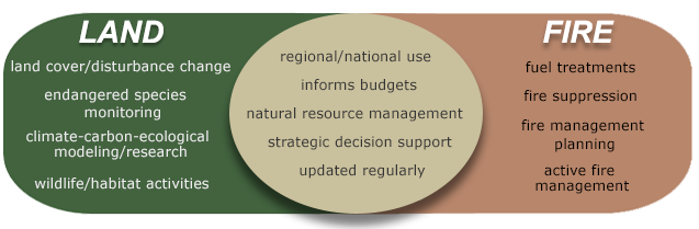
LANDFIRE data is used to establish wildfire risk for ranking funding proposals, insurance industry evaluations of risk, fire management planning, and more. This dataset is behind much of the work we do and it is important that we understand it.
LANDFIRE (LF), Landscape Fire and Resource Management Planning Tools, is a shared program between the wildland fire management programs of the U.S. Department of Agriculture Forest Service and U.S. Department of the Interior, providing landscape scale geo-spatial products to support cross-boundary planning, management, and operations.
LF data characterize the current and historical states of vegetation, fuels, fire regimes, and disturbances. LF produces a comprehensive, consistent, scientifically credible suite of more than 25 geospatial layers, a reference database, and a set of quantitative vegetation models at a national extent. LF data supports landscape assessments, analysis, and natural resource management. LF supplements and assists modeling of fire behavior and effects.
Update LANDFIRE Dataset
LF has transitioned to annual updates and needs as much time as possible to process data. LF is asking for data to be submitted or available in database systems by October 31st. Please make every effort to have your FY 2023 data accessible to LF by October 31, 2023. Data accessibility may include entering data into online databases/Systems of Record (SOR) so it can be obtained by LF. Data submitted after the deadline will be used if schedules allow. All data contributions must meet LF requirements.
The primary focus of this data call is to collect FY 2023 disturbance and treatment activities. To make annual updates possible LF is asking for data from the fiscal year which runs from 10/01/2022 – 09/30/2023. LF now requires disturbance/treatment date or fiscal year to be included with your data submission,. This will ensure your data are processed correctly. The secondary focus is to collect vegetation/fuel plot data. LF also welcomes feedback on current products.
LF needs your help to collect four types of data:
Disturbance/Treatment polygons: Disturbance and treatment polygons are first priority data for updates (LF 2012, LF 2014, etc.) and are processed and maintained in the LF Events Geodatabase.
Vegetation and Fuel Plot data:Vegetation and fuel plot data are the first priority data for mapping (LF c2001 / LF Remap) and are processed and maintained in the LF Reference Database (LFRDB)
Invasive Species Data: LF is accepting submissions of polygon or plot based invasive species data.
Lidar Data Lidar data are first priority data for mapping (LF Remap) and will be used to develop vegetation structure models.
Feedback on LF products: Feedback is secondary priority data for updates and remaps.
Submit feedback through the LF Help Desk.
For data submission, questions, or you are aware of other data sources, contact:
Brenda Lundberg
LANDFIRE Reference Data Administrator
blundberg@contractor.usgs.gov
Using LANDFIRE Data
Not everyone needs to have GIS abilities to use LANDFIRE data to understand and explore their wildfire risk. To make the dataset more accessible, the USDA Forest Service created the Wildfire Risk to Communities tool.
Wildfire Risk to Communities is built from nationally consistent data, including:
Vegetation and fire-behavior fuel models from the interagency LANDFIRE program
Topographic data from the United States Geological Survey
Historical weather patterns from the National Weather Service
Long-term simulations of large wildfire behavior from the USDA Forest Service
Community data from U.S. Census Bureau and Department of Energy
Upcoming Events and Opportunities
Webinars
SWFSC: Overview and Verification of LANDFIRE Fuels: 2022 Cooks Peak Fire
Nov 8, 2023 12:00 PM MT

A practitioner-oriented overview of LANDFIRE with a focus on fuels and how they react to modeling techniques. The subject area of discussion will be the 2022 Cooks Peak fire located in northern New Mexico. This webinar will be technical in its application and may offer insights for both beginner and advanced LANDFIRE users.
Presenters: Tobin Smail, LANDFIRE Next Gen Fuels Lead, USFS Rocky Mountain Research Station Fire Modeling Institute; and Charley Martin, LANDFIRE Fuels, TSSC Contract USGS/KBR
FACNM - Fire, Forests, and People in the Jemez Mountains, NM: The Long View from Tree Rings and Archaeology
Nov 14th, 12:00 PM MT
In this webinar from the Fire Adapted New Mexico learning network, presenter Dr. Thomas Swetnam discusses the long view on fire, forests, and people in the Southwest through the lens of tree rings (dendrochronology) and archaeology. Although the past is not a perfect guide for the future, the history of people, forests and fires in the Jemez Mountains provides useful insights for restoring and living within resilient forest landscapes today.
View the webinar by registering through Zoom or by joining through Facebook Live on November 14 at 12:00pm.
Job Opportunities
State Forestry Division is hiring two full-time year-round Wildland Fire Hotshot Crews
Applications for hotshot crew superintendent are being accepted now.
The Forest Stewards Guild is hiring a Watershed Restoration Manager in the SW
Applications for the manager are being accepted now.