Written by Steve Bassett, Spatial Analyst & GIS Program Manager | TNC New Mexico Field Office
As the Greater Santa Fe Fireshed Coalition works towards building resilience to wildfire, mitigating the risk of wildfire is a core strategy. Coalition members hope to invest in wildfire risk reduction treatments in places where risk is highest. The recently completed Greater Santa Fe Fireshed Wildfire Risk Assessment will allow targeted investment in risk mitigation. Because wildfires impact all lands, and do not stop at property boundaries, this analysis evaluates risk on all lands within the Fireshed.
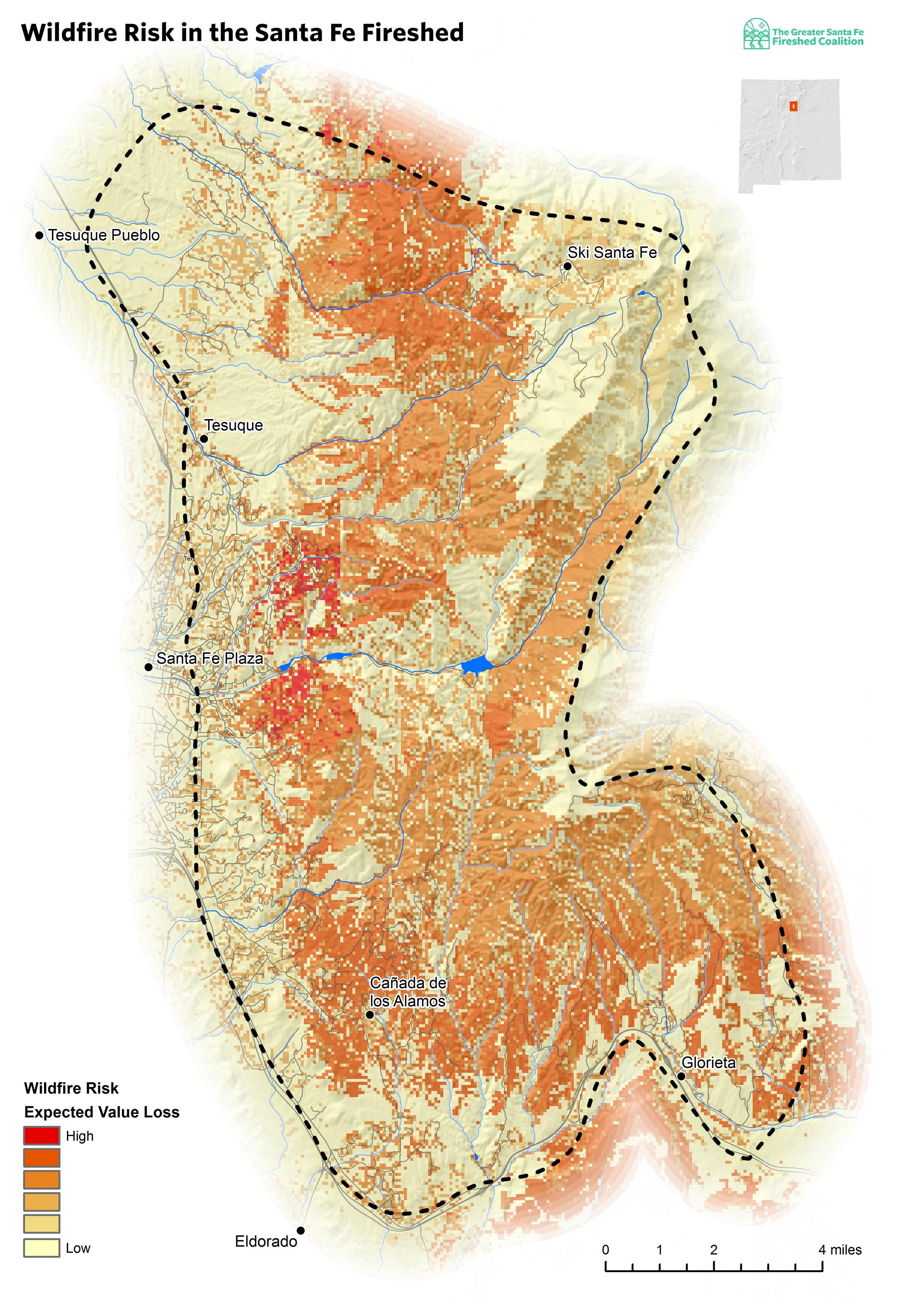
Wildfire risk is measured as the damage expected to be caused by future wildfires. Expected damage is highest where there is overlap between three components: expected likelihood of a fire occurring, expected intensity of a wildfire when one occurs, and susceptibility of the burned area to damage from the fire.
The recently completed risk assessment is based on the widely used Wildfire Risk Assessment Framework (Scott et al. 2013), that outlines the process for evaluating and combining the three components of wildfire risk. Every region is different so care was taken to ensure the application of the framework utilized the best available data and understanding of the local ecology and fuels.
“The analysis indicates nearly two-thirds of the Fireshed area is expected to lose value following anticipated wildfires.”
To determine the likelihood and intensity of expected fires, hundreds of thousands of wildfires were simulated under a range of weather conditions. Susceptibility to fire was characterized for a range of resources and assets that were identified by Coalition members. Resources and assets that were included in the assessment capture the effects of wildfire on private investments like homes and property, public infrastructure like roads and trails, watershed function such as water provisioning and flood mitigation, recreation and cultural use such as trails and ski areas, and ecological function. Because post-fire hazards such as flooding and debris flow are of concern to the Coalition, a range of post-fire hazards were included as valued resources in terms of the mitigation value of the current landscape.
The analysis indicates nearly two-thirds of the Fireshed area is expected to lose value following anticipated wildfires. The areas with the highest wildfire risk occur where multiple resources and assets overlap, for instance where high-value watersheds and residential neighborhoods are coincident. This assessment will help the Coalition and its partners coordinate their work across landownership boundaries and to utilize risk mitigation funding more effectively.
A full summary and thorough documentation of the analytical methods are available in the Risk Assessment report.
Check the events page for upcoming events including a Risk Assessment public meeting coming near you! Time and location TBD. Stay tuned!
References
Scott, Joe H.; Thompson, Matthew P.; Calkin, David E. 2013. A wildfire risk assessment framework for land and resource management. Gen. Tech. Rep. RMRS-GTR-315. U.S. Department of Agriculture, Forest Service, Rocky Mountain Research Station. 83 p.