Wildfire Wednesdays #123: How Cross-Boundary Partnerships Bolster Fire Adapted Communities - A Success Story

 Hello FAC NM followers,

Starting the process of working within our communities to become fire adapted is often challenging, and it can be even more difficult to sustain. Making headway requires a force of will, a collective push for change, and ideal conditions coalescing! While the barriers to progress can feel daunting, you are far from alone in your work to build communal resilience. This week, we highlight the success of one community’s partnerships and the extensive wildfire mitigation work that these partnerships have enabled.

Today’s Wildfire Wednesday features:

  • The story of Horseshoe Springs Association’s (HSA) Jemez Mountains wildfire mitigation work

  • Takeaways from HSA’s success

  • Updates and opportunities

Best,
Dayl


Horseshoe Springs Association’s wildfire mitigation work in the Jemez Mountains

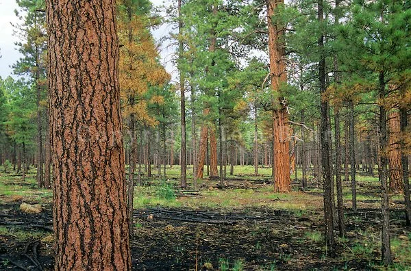
Fall scene in the Jemez Mountains captured using a drone camera. Photo by Mario Pratti

Working together for landscape resilience

Picture this: It’s a warm summer day in a lovely, forested neighborhood in the Jemez Mountains of northern New Mexico. Picturesque cabins dot the hillsides and nestle among the trees. The sun is streaming through a canopy of spruce, fir, and pine, the air smells astringent and fresh, and the sounds of equipment and voices are deadened by a hush created by the mature coniferous forest and its soft duff-covered floor. Residents are out in their yards raking pine needles, chipping slash, and pruning and thinning ladder fuels from the forest around their homes. Everyone is pitching in to do the work that can keep their community safe from wildfire. The community recently received wildfire risk mitigation funding from their local Soil and Water Conservation District, a crucial partnership which enables them to complete this work to improve defensible space in the neighborhood. Nearby, on adjacent Forest Service land, contractors are completing a thinning project on hundreds of acres that will further ensure the community’s resilience to fire. All this work lies within the footprint and is one component of a larger cross-jurisdictional project to increase the resilience of forests and watersheds…

If it sounds a bit too idyllic to be true, we invite you to learn about the Horseshoe Springs Association (HSA).

This scene (with some artistic license on the writer’s part) is the story of HSA, a neighborhood of 50 homes and cabins established in the La Cueva area of the Jemez Mountains in the 1950s and 60s. Their community showcases the success enabled by functional partnerships across agencies and organizations.

In the early days of the neighborhood, there were fire and safety rules in place that required cabin owners to rake pine needles within 30 feet of structures or fuel sources such as wood piles and propane tanks—rules which were later incorporated into the Association’s covenants. Community chipper days to process slash have been held by the Association nearly annually for the last 15 years. Moving beyond individual responsibility, the community has actively partnered with the Forest Service for decades. In the early 2000s, forest thinning to reduce tree densities was completed on HSA’s 64 acres of common land through the USDA Forest Land Enhancement Program (FLEP). The Forest Service began thinning 257 acres of National Forest adjacent to the neighborhood in summer of 2023. A recent partnership with the Cuba Soil and Water Conservation District has brought in grant funding to support hazardous fuel reduction by contractors on private land in the community.

Current status and future work

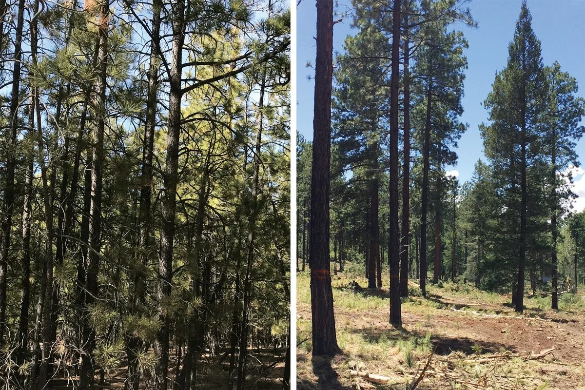
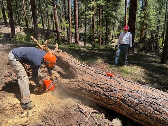
A ponderosa pine forest in the Jemez Mountains, before and after a thinning project. Sue Harrelson/USFS

As of fall 2023, 27 out of 50 cabin owners in HSA have signed up for thinning through the Cuba SWCD grant and about half of those have already had their property thinned.  Another 10-15 cabins were already at or below the target density level, leaving fewer than twenty percent of the cabins with higher-than-recommended tree density.  In addition, HSA has applied to have 20 acres of common land thinned under the grant program, focusing on the areas closest to possible ignition sources. This community-level work dovetails with the mission of the 2-3-2 Cohesive Strategy Partnership, a landscape-scale effort to promote resilient forests and watersheds in northern New Mexico and Southern Colorado. HSA lies within the project boundary of the 2-3-2, allowing for each project to leverage the funding and forest resilience work of the other by creating landscape-scale restoration areas. This overlap will further enhance the Association’s dedicated mitigation work.

Horseshoe Springs Association is well on its way to becoming fully realized as a Fire Adapted Community, but they couldn’t have done it alone. It is through cross-boundary partnerships and landscape-scale work that they continue to protect themselves from wildfires that regularly move through the Jemez Mountains. When thinking about our work in forest resilience, it is important to acknowledge that much of our regional land management wisdom is derived from the selective logging performed by Ancestral Pueblo people who coexisted with frequent fires in the Jemez. The work of HSA also takes root in the residents’ respect for fire and their understanding that “fire is a question of when, not if”, in the words of resident Brent Bonwell.


Learning from the Success of Others

Close calls as a call to action

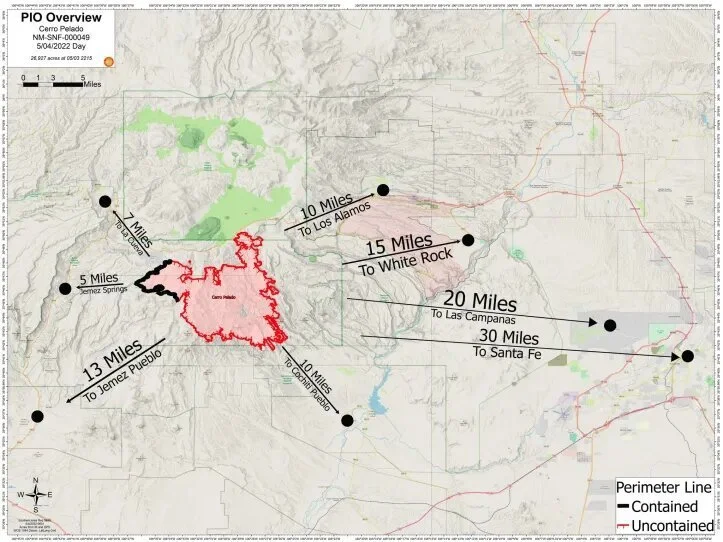
This map shows the proximity of the Cerro Pelado Fire to local communities on May 4, 2022. La Cueva, where HSA is located, was 7 miles from the fire. Image sourced from Los Alamos Reporter.

Wildfires have come close to the community - the 2022 Cerro Pelado fire came within seven miles of the neighborhood, and large fires in the past, such as Las Conchas in 2011 and Thompson Ridge in 2013, have loomed threateningly nearby. While fire has played an important ecological role in ponderosa pine forests for millennia and historical tree-ring fire scar evidence shows that the large size of these modern fires is not unusual, the high-severity tree-killing nature of them is (see this story map of fires in the Jemez). That catastrophic quality is precisely what threatens neighborhoods in the wildland urban interface (WUI), like Horseshoe Springs, and compels them to accelerate their community protection efforts.

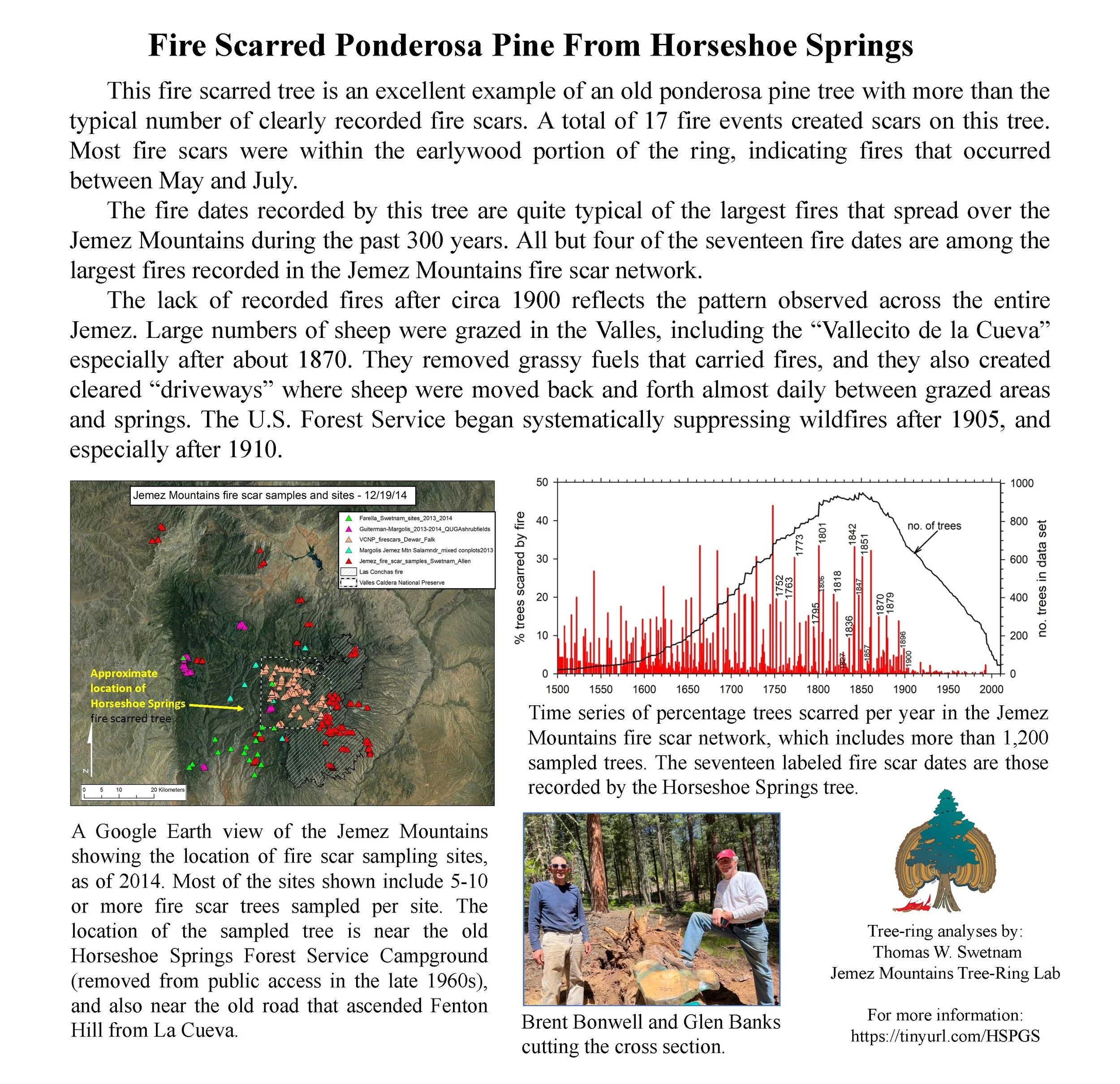
Learn more about the fire history of the La Cueva area of the Jemez Mountains in this report by Dendrochrologist Dr. Tom Swetnam.
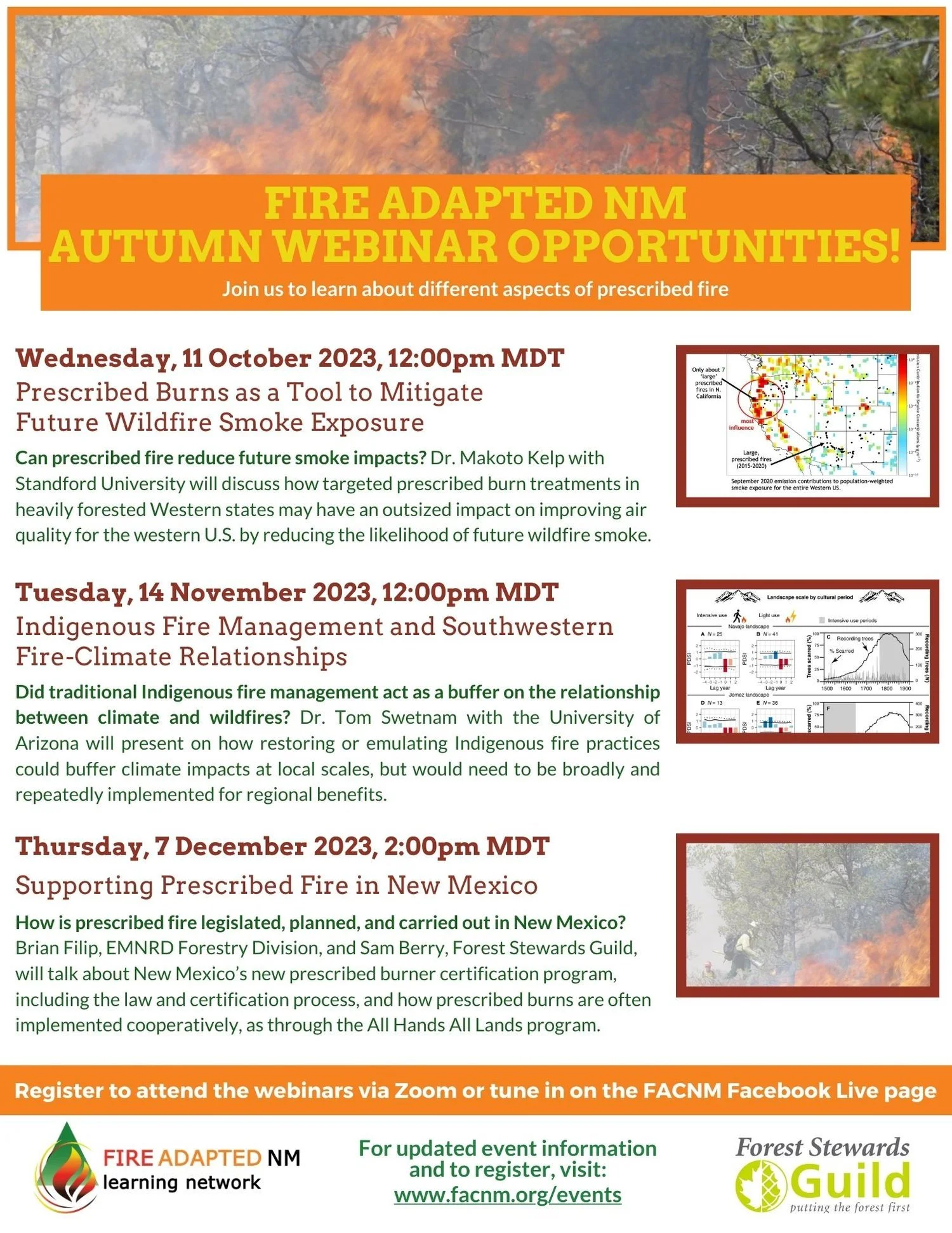
Listen to Tom speak about fire history in the area at 12pm on November 14 in a FACNM webinar on Fire, Forests, and People in the Jemez Mountains, NM.

Key takeaways from HSA’s work

Communication across boundaries is essential. Without a strong relationship with the Forest Service, Cuba SWCD, and others, much of the thinning work in and around Horseshoe Springs may never have been completed.

Opportunities to fund these projects are important—without the money, how can we do the work? Property owners within the Cuba Soil and Water Conservation District had the opportunity to enter into cost-share agreements and have up to 80% of the cost of their thinning work paid. Local grant programs like these are essential to empowering communities. FAC NM offers microgrants to provide seed funding for community protection efforts like this.

This work takes time. It has taken HSA decades, the dedication of individual landowners, and opportunistic partnerships to reach the point they are at now, with over 80% of properties in the neighborhood thinned to a recommended tree density.

Everyone has a role to play in fire adaptation and ecological restoration. It is through collective action, education, and overlapping projects that we will see large-scale fire adaptation.


Upcoming Events and Opportunities

Webinars

November 1st, 2023, 10:00 - 11:30am MDT: Smoke: State of the Science
Join for a live virtual session focused on the State of the Science about smoke. This facilitated panel discussion will be guided by your questions. Registration is required. Live session will be recorded and posted on the Rocky Mountain Research Station website here: SYCU - Webinars | US Forest Service Research and Development

REGISTER HERE

December 14th, 2023 9am - 10:30am ET: The Future is Smoky, one of four Fueling Collaboration sessions.
With increasing wildfire activity due to changes in climate, smoke will likely become more prevalent and continue to have an effect on society. Earlier this year, smoke from Canada wildfires lowered air quality in the eastern U.S. to its worst levels in recorded history. As the climate heats up and creates drier conditions, smoky skies will grow increasingly common. Health concerns and prescribed burning actions needed to restore functioning ecosystems will be impacted by already smoky conditions across the country. Panelists include research meteorologists, air quality experts, and fire practitioners. Together, they will explore how we can address and adapt to a smoky future.

REGISTER HERE

Coalitions and Collaboratives Training Opportunity, November 4-5, 2023

Two trainings associated with the 6th National Cohesive Wildland Fire Management Strategy Workshop, taking place November 6-9, 2023, are available through Workshop partner Coalitions and Collaboratives (COCO) and the USDA Forest Service.

When: Saturday and Sunday, November 4-5, 2023, 8am-4pm
Where: Eldorado Hotel, 309 W San Francisco St, Santa Fe, NM 87501
Cost: free to participate even if participants are not attending the Nov. 6-9 Workshop. Pre-registration is required.
How: email event organizers to register for the trainings using the button below.

PRE-REGISTER FOR THE TRAININGS
Learn more

Training #1: Community Wildfire Mitigation Best Practices Training 2-day short course

Community Wildfire Mitigation Best Practices (CW-MBP) is designed for current or future mitigation specialists, wildfire program leads, and others working with residents and their communities to reduce wildfire risk. CW-MBP training concentrates on science, methods, and tools to help you engage communities and residents while also helping you to eliminate ineffective practices.

Participants should come with a basic understanding of wildfires, how structures ignite, and vegetation management practices. The course assumes you know how to mitigate, but are seeking ways to engage your community. In this workshop, you will work through some of the greatest challenges facing our wildland-urban interface communities with a focus on how to increase engagement with residents and partners. The course will help you break down ineffective practices to make space for the more effective ones with a focus on on-the-ground mitigation activities.

Training #2:  Leading the CWPP Process – Learn how to lead the Community Wildfire Protection Planning process

Over two days, you will learn and practice how to facilitate a CWPP process and leave with templates and access to coaching.

Participants will learn about:

  • Mapping the process of CWPP development

  • Assessing local risk with everyday tools

  • Gathering community input

  • Prioritizing treatments with partners

  • Creating and implementing an action plan

Participants will receive:

  • Ready-to-use CWPP document template

  • Individual coaching after the class

  • Community assessment, survey, and outreach templates

Wildfire Wednesdays #122: LANDFIRE data and planning

Wildfire Wednesdays #122: LANDFIRE data and planning

Hi Fireshed community,

As wildfire frequency and severity continue to increase, we must be strategic in where and when we complete forest restoration and wildfire risk reduction work. As Forest Service chief Vicki Christiansen put it, '“instead of random acts of restoration, we must share decisions and place treatments where they can produce desired outcomes at a meaningful scale.”

To support strategic planning for wildfire risk reduction, we must use the best available data for the biophysical conditions within our planning areas. One of the most commonly used data sources for planning fire and forest management projects, is LANDFIRE data. Our planning and modelling for fire and forestry projects is limited by the quality of the LANDFIRE dataset. With this in mind, this week’s Wildfire Wednesdays will focus on sharing information about how we can improve the quality and accuracy of the LANDFIRE dataset by providing input for the 2023 update that is happening now.

This Wildfire Wednesday’s includes:

  • An overview of LANDFIRE data

  • Information about how to provide updates to the LANDFIRE dataset

  • Wildfire Risk to Communities - a user-friendly tool for LANDFIRE data

  • A webinar about how LANDFIRE data is used for modelling

  • General updates and opportunities

Best,
Gabe

LANDFIRE Overview

LANDFIRE data is used to establish wildfire risk for ranking funding proposals, insurance industry evaluations of risk, fire management planning, and more. This dataset is behind much of the work we do and it is important that we understand it.

LANDFIRE (LF), Landscape Fire and Resource Management Planning Tools, is a shared program between the wildland fire management programs of the U.S. Department of Agriculture Forest Service and U.S. Department of the Interior, providing landscape scale geo-spatial products to support cross-boundary planning, management, and operations.

LF data characterize the current and historical states of vegetation, fuels, fire regimes, and disturbances. LF produces a comprehensive, consistent, scientifically credible suite of more than 25 geospatial layers, a reference database, and a set of quantitative vegetation models at a national extent. LF data supports landscape assessments, analysis, and natural resource management. LF supplements and assists modeling of fire behavior and effects.

Update LANDFIRE Dataset

LF has transitioned to annual updates and needs as much time as possible to process data. LF is asking for data to be submitted or available in database systems by October 31st. Please make every effort to have your FY 2023 data accessible to LF by October 31, 2023. Data accessibility may include entering data into online databases/Systems of Record (SOR) so it can be obtained by LF. Data submitted after the deadline will be used if schedules allow. All data contributions must meet LF requirements.

The primary focus of this data call is to collect FY 2023 disturbance and treatment activities. To make annual updates possible LF is asking for data from the fiscal year which runs from 10/01/2022 – 09/30/2023. LF now requires disturbance/treatment date or fiscal year to be included with your data submission,. This will ensure your data are processed correctly. The secondary focus is to collect vegetation/fuel plot data. LF also welcomes feedback on current products.

LF needs your help to collect four types of data:

  • Disturbance/Treatment polygons: Disturbance and treatment polygons are first priority data for updates (LF 2012, LF 2014, etc.) and are processed and maintained in the LF Events Geodatabase.

  • Vegetation and Fuel Plot data:Vegetation and fuel plot data are the first priority data for mapping (LF c2001 / LF Remap) and are processed and maintained in the LF Reference Database (LFRDB)

  • Invasive Species Data: LF is accepting submissions of polygon or plot based invasive species data.

  • Lidar Data Lidar data are first priority data for mapping (LF Remap) and will be used to develop vegetation structure models.

  • Feedback on LF products: Feedback is secondary priority data for updates and remaps.
    Submit feedback through the LF Help Desk.

For data submission, questions, or you are aware of other data sources, contact:

Brenda Lundberg
LANDFIRE Reference Data Administrator
blundberg@contractor.usgs.gov

Using LANDFIRE Data

Not everyone needs to have GIS abilities to use LANDFIRE data to understand and explore their wildfire risk. To make the dataset more accessible, the USDA Forest Service created the Wildfire Risk to Communities tool.


Wildfire Risk to Communities is built from nationally consistent data, including:

  • Vegetation and fire-behavior fuel models from the interagency LANDFIRE program

  • Topographic data from the United States Geological Survey

  • Historical weather patterns from the National Weather Service

  • Long-term simulations of large wildfire behavior from the USDA Forest Service

  • Community data from U.S. Census Bureau and Department of Energy

Upcoming Events and Opportunities

Webinars

SWFSC: Overview and Verification of LANDFIRE Fuels: 2022 Cooks Peak Fire

Nov 8, 2023 12:00 PM  MT

A practitioner-oriented overview of LANDFIRE with a focus on fuels and how they react to modeling techniques. The subject area of discussion will be the 2022 Cooks Peak fire located in northern New Mexico. This webinar will be technical in its application and may offer insights for both beginner and advanced LANDFIRE users.

Presenters: Tobin Smail, LANDFIRE Next Gen Fuels Lead, USFS Rocky Mountain Research Station Fire Modeling Institute; and Charley Martin, LANDFIRE Fuels, TSSC Contract USGS/KBR

Register


FACNM - Fire, Forests, and People in the Jemez Mountains, NM: The Long View from Tree Rings and Archaeology

Nov 14th, 12:00 PM MT

In this webinar from the Fire Adapted New Mexico learning network, presenter Dr. Thomas Swetnam discusses the long view on fire, forests, and people in the Southwest through the lens of tree rings (dendrochronology) and archaeology. Although the past is not a perfect guide for the future, the history of people, forests and fires in the Jemez Mountains provides useful insights for restoring and living within resilient forest landscapes today.

View the webinar by registering through Zoom or by joining through Facebook Live on November 14 at 12:00pm.

Register

Job Opportunities

State Forestry Division is hiring two full-time year-round Wildland Fire Hotshot Crews

Applications for hotshot crew superintendent are being accepted now.

Click Here to Apply

The Forest Stewards Guild is hiring a Watershed Restoration Manager in the SW

Applications for the manager are being accepted now.

Click here to apply


Wildfire Wednesdays #121: Understanding Past, Present, and Future Fire Patterns Through Tree-Ring Fire-Scar Analysis

Hello, Fireshed readers!

My name is Dayl Velasco. I’m a project coordinator at the Forest Stewards Guild and the newest contributor to the Fireshed blog. Much of my work revolves around fire, from assisting with prescribed burns to collecting data on forest health pre- and post-thinning and burning to measure landscape resilience, and I’m excited to continue working in this realm as I help to coordinate this publication. Nice to meet you!

Today’s Wildfire Wednesday focuses on how scientists use the life history of fire scarred trees that is recorded in their rings (seen in a crosscut of wood) to understand historic fire regimes and date specific fire events. You’ll be introduced to the North American Tree-Ring Fire-Scar Network, which was compiled in 2022 and contains over 37,000 sampled trees across North America. You’ll learn about work closer to home with a brief overview of New Mexico’s own Jemez Mountains Tree-Ring Lab and the research they do and the story of a recently analyzed old ponderosa pine that fell near Jemez Springs and offered its tales up to science, to be absorbed into the tree-ring network. Throughout, we’ll keep in mind how this research guides our work to build resilience in our forests and communities.

This Wildfire Wednesday features information on:

  • Understanding past, present, and future fire patterns through tree-ring fire-scar analysis

  • Close to home: the largest mountain-range fire scar network in North America

  • Applying the science to FACNM

  • Resources and Upcoming Opportunities

-Dayl


Understanding past, present, and future fire patterns through tree-ring fire-scar analysis

Back to basics: what is tree ring analysis?

Ellis Margolis cross dates an old piece of ponderosa pine from the Tesuque watershed outside of Santa Fe, New Mexico. Collin Haffey, USGS Public domain.

In a world where wildfires are increasing in severity year-after-year, driven by climatic changes and increased fuel loads as a result of over 100 years of fire suppression, we know that fire is a force we must learn to live with. This is especially true in the southwest’s fire-adapted forests. As we move toward adaptation ourselves, it is helpful to ground our current understanding of wildfire in the context of centuries-old fire regimes. So, how do we build this historical context?

This is where the trees and the scientists who study them come in. First, some basics: if you’ve ever seen a cut tree stump, you’ve probably noticed that the top of a stump has a series of concentric rings. These rings can tell us how old the tree is, and what the weather was like during each year of the tree’s life. The light-colored rings represent wood that grew in the spring and early summer, while the dark rings represent wood that grew in the late summer and fall. One light ring plus one dark ring equals one year of the tree’s life (NASA, 2017). Dendrochronology is the study of these tree rings to answer questions about the natural world and the place of humans in its functioning.

Trees contain immense histories in their rings and dendrochronologists understand how to read and interpret these records. The information preserved in tree-ring growth records, from fires to weather conditions, reads like a history of the land where they grew for their entire life span - that can be over 1,000 years for some trees! Historical environmental conditions are expressed as wide or narrow rings or changes in growth patterns. Wide rings indicate years of plentiful moisture while narrow rings indicate drought. Ring width can also be correlated with temperature, especially in cooler climates and higher elevations. Learn more about tree rings from the Laboratory of Tree-Ring Research.

Fire scar position and seasonality within the tree-ring and corresponding calendar year.

When a fire moves through a forest, some trees may burn and experience damage to their cambium - or living tissue just below the bark - but not die. This results in a fire scar, where a tree produces sap to cover its scorch wound. As the tree heals and grows around the scorch wound, these scars remain visible within the growth ring of the year in which the fire occurred. It’s important to note that if a tree has recorded multiple fire events, the fires it experienced were likely low- to moderate-severity, or just intense enough to create a scar but not enough to kill the tree. High-severity fires are traceable through tree rings as well, but scientists depend on a record from trees that were able to survive on the less intense outer edges of these fires since trees in the middle are often casualties of the blaze. A robust dataset of tree-ring fire scars, taken from a broad area, can tell us the exact year and season a fire burned, its severity and size, and overall fire frequency from centuries before modern records began.

This field fire history reconstruction through tree-ring fire scars is called Dendropyrochronology (for all you logophiles out there). Read a more in-depth description of fire history reconstruction here.

The North American Tree-Ring Fire-Scar Network

Yellow dots represent the more than 2,500 fire-scar sites that currently make up the network across North America. Credit: Ellis Margolis, USGS.

The North American Tree-Ring Fire-Scar Network was formed in 2022 and compiles tree-ring data from more than 2,500 sites across the entire North American continent. Through the network arise new opportunities to understand the influences of climate, humans, and land use on past, current, and future fire regimes.

The team that undertook the monumental task of analyzing data from more than 37,000 fire-scarred trees across North America found evidence of historical low-severity fire in all but two ecoregions of the continent. This evidence was often found in areas that have not burned for one hundred years or more due to anthropogenic fire suppression.

The network also shows that human influence strongly impacts fire regimes. This is clearly demonstrated at the border of the United States and Mexico, where fires stopped being recorded in the tree ring record on the U.S. side around 1900 as suppression became the norm (creating the fire deficit that helped set the stage for modern megafires), but on the other side in northern Mexico fires continued to burn, be recorded in tree rings, and maintain resilient ecosystems to the present day.

Read more about the North American Tree-Ring Fire-Scar Network in this article.


Dendropyrochronology Close to Home

The largest mountain-range fire scar network in North America: fire regime reconstruction in the Jemez Mountains

The tree-ring fire scar network in the Jemez Mountains covering >300,000 acres.  Colored symbols represent individual fire-scarred trees from different collections over 30 years. Public domain.

Let’s zoom back in on the Southwest. There is a long history of tree-ring research here, with plentiful old trees, aged tree stumps, and remnant wood present in archaeological structures. Over the past 30 years, New Mexico researchers have built the largest tree-ring fire scar network for a single mountain range - the Jemez Mountains - in North America. The Jemez network currently includes 1,343 trees and 9,014 fire scars with these numbers ever-increasing. The Jemez Mountains Tree-Ring Lab has many concurrent research projects across the Southwest in service of the overarching goal of researching the effects of climate variability on forest ecology, fire ecology, and ecohydrology. Locally, in the Jemez mountains, the lab is working to understand the area burned since 1600 CE over a 300,000-acre landscape. These fire reconstructions allow scientists to place the large fires of recent years into a historical context.

Tree Ring Analysis from Horseshoe Springs

Brent Bonwell cutting the cross section.

Shortly after the completion of a forest thinning treatment near Jemez Springs, Horseshoe Springs community member Brent Bonwell noticed that a large dead ponderosa pine had fallen, and upon closer observation he saw a well-defined fire scar at its base.  He wondered if it would be possible to learn about the fire history of the area by cutting a cross section from the tree and having the tree rings dated to determine exact years of fire events. The tree had seen more than the typical number of fire events in its lifetime, with 17 total scars recorded. 13 of the 17 fire events coincide with some of the largest fires recorded among other fire scar sampling sites in the Jemez Mountains. The tree showed no fires recorded after 1900, reflecting the systematic fire suppression that began at the turn of the 20th century. Read the full report written by Thomas Swetnam of the Jemez Mountains Tree-Ring Lab.

Applying the science

How fire history guides our work with Fire Adapted Communities

Ponderosa pine forest after thinning and burning.

The research being done at tree-ring labs across the world focuses on the interactions between humans, ecosystems, fire, and climate. Many studies are designed to inform forest and fire management decisions by enabling the comparison of our present fire regimes to centuries-long records and historic regimes. In populated areas where communities and their water supplies are potentially threatened by high-severity fires, science-management partnerships use tree ring research to guide land management decisions and goals, with a prime local example being the landscape-scale work of the Greater Santa Fe Fireshed Coalition. Historical reference points provided by tree ring collections and data give managers examples of more resilient forest conditions and fire regimes. Managers can in turn work toward these ideal conditions when acting to restore forests and fire regimes and mitigate wildfire risk in our wildland-urban interface. Every little bit of ecologically-informed forest restoration, whether it's happening on thousands of acres of federal land or in your back yard, is a step in the direction of protecting communities, returning ecosystem functions and biodiversity, and addressing climate change.


Resources and Upcoming Opportunities

In-person Learning

Applications due October 15th: Fire Leadership For Women (FLFW) 20-Day Session

The National Interagency Prescribed Fire Training Center (NIPFTC) is hosting three training sessions for women in wildland fire management. Participants will experience 10 to 12 days of hands-on burning in complex situations such as wildland urban interface, various fuel types, and will work for several different agencies with unique management objectives. Participants will gain up-to-date knowledge on prescribed fire safety, prescribed fire planning, smoke screening tools, monitoring, and current fire policy.

January session: 01/07/2024 through 01/26/2024

February session: 02/11/2024 through 03/01/2024

March session: 03/10/2024 through 03/29/2024

Learn more about fire leadership for women

October 26, 6:00pm, Taos, NM: Future Forests- Living with Fire

Join The Nature Conservancy for a conversation with a panel of experts to talk about the future of forests and how we can manage our forests better in New Mexico. TNC’s Forest and Watershed Health Manager Matt Piccarello will moderate this session that will include an opportunity for audience members to ask questions of the experts.

Webinars

FACNM Fall Webinar Series: Prescribed Fire in New Mexico

FACNM is hosting speakers from across the state (and the country) this autumn to talk about many different aspects of prescribed fire!

First up, join us on October 11th to hear Dr. Makoto Kelp present research that indicates that prescribed fire implemented in priority areas in the West may lower the likelihood and severity of future wildfire smoke during a joint FACNM-SWFSC webinar. Register Now!

On November 14, Dr. Tom Swetnam will discuss research showing that traditional Indigenous fire management may have interrupted the connection between climatic conditions and wildfire behavior at a local level.
To close the series, on December 7, Sam Berry and Brian Filip will discuss implementation of prescribed fire in the state of New Mexico, including the new Prescribed Burner Certification Program and All Hands All Lands. Download the flyer to learn more.

Keep an eye on the FACNM Events page for November and December webinar registration announcements!

Additional Reading and Resources

3 Things Outdoor Recreationists Need to Know About Wildfire Outdoor Alliance article on how recreationists can support a more fire resilient future through education and support for policy reform.

WildfireSAFE provides simplified access to an advanced suite of fire weather and products to support fire management decisions. Visit the website to view weather & potential for wildfires across the nation. 

Wildfire Wednesdays #120: Recognizing Community Distinctness in Fire Adaptation and Preparation

REPOSTED to highlight Resources and Upcoming Opportunities

Hello Fireshed folks!

It may seem like common sense, but different communities perceive wildfire, wildfire risk, resilience actions, and personal wildfire risk differently. Even within a small town, individual neighborhoods likely vary wildly in their perception of and readiness for wildfire. As fires grow more extreme across the West and transition from wildlands to widespread house fires more often, effective implementation of wildfire preparedness strategies is becoming more important. Today’s blog provides information on the importance of tailoring fire prevention and preparedness messaging to individual communities to address their unique needs and barriers.

This Wildfire Wednesday features information on:

  • Resources and upcoming opportunities

  • How perceptions of fire risk vary across communities

  • The importance of tailoring fire education programming

Take care and enjoy the autumn equinox!
Rachel


Resources and other Opportunities

Funding opportunities

FACNM Microgrants Round 2 - Closes September 30!

The microgrant program from FACNM provides up to $2,000 for activities related to community fire preparedness, including community chipper days, educational events, meetings, public thinning demonstrations, and more! Applicants must be a FACNM Member or Leader (take 10 minutes to apply to join) and can apply for funding through a short Google Forms questionnaire. Learn more about the microgrant program and read about past recipients.

APPLY FOR A FACNM MICROGRANT!

The Ready, Set, Go! Program, provided by the USDA and managed by the International Association of Fire Chiefs, is accepting proposals from fire departments across the country to fund on-the-ground fuels reduction projects in communities. Eligible projects include Thinning, limbing, mastication; Grazing programs; Chipper days; Transfer of slash and fuels to a burn or disposal site; Development of a burn pad or debris collection site; and Defensible Space Projects. Applicants must be Ready, Set, Go! program members (join for free). Learn more about the funding opportunity.

Learn more
APPLY FOR FUNDING

In-person learning

September 30, 9:00am - 1:00pm, Ojitos Frios, NM: Living with Fire - Protecting your Home in the Next Fire
Querencia in Action is partnering with Luna Community College and New Mexico Forestry Division to present a free workshop on home hardening techniques such as pruning, limbing, tree thinning and creating Survivable Space. Click on the image to learn more.

October 26, 6:00pm, Taos, NM: Future Forests- Living with Fire
Join The Nature Conservancy for a conversation with a panel of experts to talk about the future of forests and how we can manage our forests better in New Mexico. TNC’s Forest and Watershed Health Manager Matt Piccarello will moderate this session that will include an opportunity for audience members to ask questions of the experts.

EMAIL THE ORGANIZER TO REGISTER!

Webinars

FACNM Fall Webinar Series: Prescribed Fire in New Mexico
FACNM is hosting speakers from across the state (and the country) this autumn to talk about many different aspects of prescribed fire!

First up, join us on October 11th to hear Dr. Makoto Kelp present research that indicates that prescribed fire implemented in priority areas in the West may lower the likelihood and severity of future wildfire smoke during a joint FACNM-SWFSC webinar.
On November 14, Dr. Tom Swetnam will discuss research showing that traditional Indigenous fire management may have interrupted the connection between climatic conditions and wildfire behavior at a local level.
To close the series, on December 7, Sam Berry and Brian Filip will discuss implementation of prescribed fire in the state of New Mexico, including the new Prescribed Burner Certification Program and All Hands All Lands. Download the flyer to learn more.

Register for the October webinar or watch it live on Facebook and keep an eye on the FACNM Events page for November and December webinar registration announcements!

Fire Risk: Perceptions and Preparedness

How risk perception varies across communities

(Note: much of the following comes from Actionable social science can guide community level wildfire solutions, a research article recently published in the International Journal of Disaster Risk Reduction.)

The Marshall Fire in Colorado; photo by RJ Sangosti via the Denver Post.

Devastation of communities due to wildfires is an important issue. Extreme wildfires, which have become more common in recent years, threaten the economic and social resilience of communities located in the wildland-urban interface (WUI) - where wildland fuels meet residential development. A wildfire with extreme behavior and impacts can destroy a high proportion of homes, associated infrastructure, and the social fabric of a community. As recent wildfires, such as the Lahaina fire in Maui, Hawaii, have shown, one critical aspect of WUI fire disasters is that they have the potential to become a home ignition problem - where the fire transitions from burning natural fuels such as grass and trees to burning human-built structures. These fires have the capacity to become mass conflagration events, with fire jumping from one house to the next.

Wildfire practitioners often know, based on their personal experience and knowledge of an area, that education efforts should be differentiated across the communities they serve. However, those tasked with getting in front of the problem by promoting mitigation and preparation rarely have the data they need to move beyond a one-size-fits-all approach. Social research shows that WUI communities and their residents vary in their relationships to wildfire and their landscapes. While distinct communities, even if they are geographically close, may exhibit similar attitudes toward wildfire in general, there are often significant differences in their perception of community fire risk - and in the types of fire preparedness educational materials that are most effective in informing and motivating residents and homeowners to take action.

Even when clear guidelines about what residents can do to reduce the ignitability of their homes is presented, implementation of such guidelines is inconsistent across the WUI.

The importance of tailoring fire education programming

In places where mitigation of wildfire risk on private property is largely voluntary (such as Canada, the US, and Australia), community-based wildfire programs often play a key role in educating and motivating residents to mitigate risk. In addition to encouraging wildfire risk mitigation, these programs support residents’ efforts to prepare for a wildfire event through education, building social cohesion, and financial and logistical assistance with implementation.

Differences in fire perception amongst distinct communities mean that fire adaptation programs and community leaders who wish to enact meaningful change need to tailor wildfire preparation and mitigation programs to the local context. To customize the information shared with residents appropriately, program leaders first need to understand local perceptions of fire, such as what the community views as necessary or effective risk mitigation behaviors, common barriers to mitigation, and community communication preferences.

So, how do program managers and community leaders begin the process of understanding local perceptions, and from there craft outreach efforts, tangible assistance, and educational materials that speak to localized risk and needs? Community surveys, such as those conducted by WiRē – Wildfire Research, can provide locally scaled data to develop richer, more actionable insights for wildfire education programs. This type of social research seeks to measure how WUI residents engage with wildfire risk and often includes broad explorations of demographic characteristics, social profiles, and processes, including wildfire attitudes and perceptions, the role of social capital and adaptive capacity, and behaviors to mitigate fire risk.

When those in leadership positions have a baseline understanding of distinct communities, they can begin to identify gaps in preparedness and blind spots in community perception of risk, then develop programs that provide the resources to fill those gaps. Imagine that homeowners and residents in a neighborhood that abuts National Forest System lands view their wildfire risk as low, but fire managers or county fire department personnel perceive their risk as high due to the likelihood of spread from the forest to houses. Developing an understanding of that community perception provides a roadmap for program managers to tailor their approach by presenting facts about actual versus perceived risk and offering options to increase resilience within that specific community. At their core, local education efforts seek to align resident expectations, and subsequent resilience actions, with the perspectives of wildfire professionals.