Wildfire Recovery Event July 23 and 24 - Las Vegas, NM

Celebrate community resilience this weekend!

Residents impacted by the Hermit’s Peak/Calf Canyon wildfires and flooding are invited to Rise, Register, and Recover in Las Vegas, NM this Saturday and Sunday.

On Saturday, July 23, from 2:00-8:00pm, enjoy a concert and wildfire relief benefit raffle in the Plaza Park.

On Sunday, July 24, from 1:00-4:00pm, meet at Memorial Middle School for a resource fair and supply distribution focused on sharing information with the community and helping everyone move forward with long-term recovery.

This event is free and open to the public.

Please help share the word!

Wildfire Wednesday #90: Community Forestry

Following a devastating start to the 2022 fire season, New Mexico residents are facing the challenging reality of wildfire recovery. A Hermit’s Peak/Calf Canyon flood warning map is available from Highlands University. Those affected by recent and ongoing fires can learn more by visiting the After Wildfire (afterwildfirenm.org) website. Mental health resources are also available from our last Wildfire Wednesdays post. Finally, refer to the bottom of this blog post for land restoration workshop opportunities happening now for landowners impacted by the Hermit’s Peak/Calf Canyon Fire.


Hello Coalition members and partners,

We hope you’re staying cool as the hot summer days fly by. This week we will be introducing an often-overlooked niche of land management: community forestry. This concept involves local communities as active participants in the stewardship of surrounding forested lands. It also helps build capacity to meet multiple objectives - reducing fire risk, improving forest health and habitat, and maintaining cultural and community vitality.

This week features information on:

  • Existing community forestry programs in the West

  • Forest Council initiatives in New Mexico

  • Opportunities to learn more about community forestry, other community-led initiatives, and funding for community forests

  • Past examples of how communities have come together for post-fire response and recovery

Take care and have a wonderful Wednesday,

Rachel


Existing Community Forestry Programs

How can we learn from the paths that others have already forged?

The exact configuration of community forestry initiatives - the land jurisdiction, leadership, and their objectives - can vary widely. Here are a few highlights from those who have led by example.

Mt. Adams Community Forest: A new model of forest ownership for the West

A checkerboard satellite map with land ownership boundaries overlaid

Land ownership in the vicinity of Mt. Adams Community Forest: image courtesy of Mt. Adams Resource Stewards

Established in 2011, Mt. Adams Community Forest is the State of Washington’s first nonprofit-owned working community forest. The project began with an opportunity and subsequent fundraising to purchase the 100-acre Glenwood Valley’s Mill Pond property with its productive forests, restoration opportunities, water, and recreation resources. A few years later, community members and friends of Mt. Adams Resource Stewards (MARS) rallied again to purchase an adjacent 285-acre block in the form of Pine Flats Forest, followed by additional acquisitions in 2020. While the group is looking continually looking for opportunities to grow the forest through future land acquisitions, their focus is on growing a locally meaningful model of conservation and stewardship.

In their words, “the Mt. Adams Community Forest strives to permanently protect high community- and conservation-value forests critical to the quality of life of [south-central Washington]. Management goals for community forest properties are centered around principles of land stewardship, community benefit, and healthy functioning ecosystems. Such goals recognize the value of sustainably managed forest resources as a renewable source of wood products and jobs, balanced with the provision of habitat for flora and fauna, and public access for recreation. Tradition is an important element of the Mt. Adams Community Forest vision, and activities such as fishing, hunting, and firewood gathering are provided for when possible.”

Flowering bushes of purple and yellow color the understory of a pine forest with scattered woody debris and oak trees

Pine Flats Tract: image courtesy of Mt. Adams Resource Stewards

While management of the forest is carried out by the nonprofit landowners, Mt. Adams Resource Stewards, community members provide guidance on management priorities through public listening sessions and direct recommendations from their community advisory committee.

Learn more about Mt. Adams Community Forest

Western Klamath Restoration Partnership

“The Western Klamath Restoration Partnership (WKRP) began in 2007, focusing on in-stream fish habitat restoration of the Middle Klamath River sub-basin. It became a 1.2-million-acre upslope restoration collaborative incorporating an “all lands” approach to address threats to people, property, cultural and natural resources at risk of high-intensity wildfire.” It has since grown in scope and size to include more partners, entire landscapes, and new objectives, but stays true to its original intent: to build trust and a shared vision for restoring fire resilience at the landscape scale.

A map showing the WKRP's geographic area, land ownership, and project plans.

Geographic scope and planning area of the Western Klamath Restoration Partnership. Image courtesy of WKRP.

The WKRP is a unique project which began as a community-stewardship initiative and has expanded into a multidimensional collaborative of diverse stakeholders. Their trajectory offers many lessons learned, such as finding common ground through identification of Zones of Agreement (geographic areas where all parties agree upslope restoration needs to occur). Through honest dialogue using Open Standards Process for Conservation, they have been able to create a plan for restoring fire resilience at the landscape scale which is founded upon Traditional Ecological Knowledge (TEK) and practices and concepts outlined in the National Cohesive Wildland Fire Management Strategy.

Flowchart showing conservation measures partnership open standards: 1 conceptualize, 2 plan actions and monitoring, 3 implement actions and monitoring, 4 analyze, use, and adapt, and 5 capture and share learning

Visualization of the Open Standards Process for Conservation. Image courtesy of the Western Klamath Restoration Partnership

A hallmark of the partnership “is the Karuk Tribe’s knowledge of fire, passed down from generation to generation. This ‘traditional ecological knowledge’ (TEK) shows us that traditional human/fire relationships of our past can guide the strategies of our future. Representatives from the Karuk Tribe, Mid Klamath Watershed Council, Salmon River Restoration Council, and the US Forest Service are co-leads of the collaborative group, but many other stakeholders, communities and organizations are involved.”

LEARN MORE ABOUT WESTERN KLAMATH RESTORATION PARTNERSHIP

New Mexico Forest Councils

Forest Councils lay the groundwork for local residents to actively steward forested lands as a way to protect water, property and their way of life. While the Councils represent a broad and customizable organization structure, they consistently fill the role of providing governance and leadership for community-forestry efforts.

Cerro Negro Forest Council

A nonprofit entity led by representatives from five local organizations, “the Cerro Negro Forest Council represents residents of Valdez, San Cristobal and Gallina Canyon in their efforts to improve forest health and prevent devastating wildfires in parts of Taos County, New Mexico… The council has adopted the principles of acequia water management and are applying those principles to community-led forestry as a way for locals to generate an income from wood products while improving the health of their forests and watersheds.” Established in 2018, the Forest Council structure is modeled after a community-based forest stewardship program which ran for many years out of the U.S. Forest Service - Camino Real Ranger District.

Cerro Negro puts this model of community-led stewardship into action through implementation of their Forest Mayordomo Collaborative Forest Restoration Program project. Local woodcutters, or leñeros, are assigned and made responsible for thinning of small forested blocks on federal land. In return they receive a per-acre work stipend and can harvest all woody material they cut. This work is carried out under the supervision of the Forest Council’s mayordomo and asistante to ensure that treatments comply with the rules and regulations of the U.S. Forest Service.

Rio de Las Trampas Forest Council

Modeled after the successful Cerro Negro Forest Council and brought back home to the Camino Real Ranger District, Rio de Las Trampas Forest Council’s mission is “to foster collaboration and community involvement in forest and watershed health projects through the implementation and administration of stewardship agreements.” Their work is driven by the understanding that climate change, intense wildfires, unnaturally dense forests, and drought threaten the lands that support their communities.

A multi-generational family poses atop a pile of firewood

A wood pile in El Valle gathered through the original USFS community forestry program which led to the creation of the Forest Councils. Photo by Kay Mathews.

The Council knows that “it is possible and replicable to partner with federal land managers to accomplish thinning objectives and reduce wildfire risk while providing a maximum benefit to local residents” and puts this knowledge into practice through their 2019 CFRP Supporting the Rio de Las Trampas Forest Council’s Leñero Program. This project replicates Cerro Negro’s Forest Mayordomo CFRP by training, educating, and paying local leñeros to thin and treat acres of federal land. In the end, this project aims to “provide fuelwood to the community, achieve forest thinning goals, and offer local residents the opportunity to care for the land”.

Read more about the Rio de Las Trampas Forest Council’s mission and model of community forestry.


Learning Opportunities

Deep-dive into the world of community forestry!

An up-close view of a small-diameter aspen log deck

Photo by Scott Ishimara, copyright.

Empowering Community-led Forest Stewardship webinar on July 28, led by The Nature Conservancy, New Mexico. Healthy forests and wood products are essential to sustaining our communities and traditional use practices in New Mexico, but access to forests has been inhibited by multiple barriers. To address those challenges and discuss opportunities, The Nature Conservancy is hosting a free virtual event, generously supported by the Taos Ski Valley Foundation.

Register Now!

Get funded through the USDA’s Community Forest Program

“The Community Forest Program (CFP) is a competitive grant program that provides financial assistance to tribal entities, local governments, and qualified conservation non-profit organizations to acquire and establish community forests that provide community benefits. Community benefits include economic benefits through active forest management, clean water, wildlife habitat, educational opportunities, and public access for recreation.”

This program funds establishment of private forest lands for community use which meet certain qualifications. Mt. Adams Community Forest, the program highlighted in the first section of this newsletter, is funded in part by the CFP!

MORE ABOUT THE COMMUNITY FOREST PROGRAM

Learn about the community’s role in stewarding our urban forests

The New Mexico Energy, Minerals, and Natural Resources Department runs and Urban and Community Forestry Program to help communities develop and sustain healthy urban forests.

A planted seedling in the foreground against the backdrop of the shovel used to plant it

Image courtesy of NM EMNRD

They expand the definition of community forests to include all trees, vegetation, and associated natural resources within and around an inhabited area. Community trees include park trees, trees along streets and neighborhoods, and any trees within the wildland-urban interface between communities and adjacent forestlands.

The services offered by the Urban and Community Forestry are borne of the understanding that urban forests deliver tremendous value to communities and the people that live there. Trees contribute to reduced storm water runoff, improved air and water quality, increased property values, improved quality of life for citizens, increased economic development opportunities, and reduced energy use at homes and businesses.

VISIT EMNRD'S URBAN AND COMMUNITY FORESTRY PROGRAM WEBPAGE

Post-fire Community Response and Recovery

How can the community come together following a wildfire?

As a community, the other side of fire preparedness is how we come back together to respond to, recover from, and maintain our culture and traditions following a fire.

Learn about one Tribe's collaborative journey to develop forest resiliency and how Santa Clara Pueblo Forestry has been able to incorporate lessons learned from past wildfires into new Fire and Forest Management Plans to keep fire an active component in maintaining the landscape.

One takeaway from Santa Clara Pueblo’s experiences is that adapting to wildfire needs to happen both before and after the fire. Lindsey Quam and Gabe Kohler took that to heart and offer low-cost strategies for flooding and erosion mitigation is this 2019 FACNM article. These methods were part of a landscape-scale effort to mitigate flooding and erosion after the 2011 Los Conchas fire but are powerful tools for response and recovery that can be used to leverage the people-power in any community and make an impact against flooding and erosion before it occurs.

For landowners impacted by the Hermit’s Peak/Calf Canyon Fire, Luna Community College and the Forest and Watershed Restoration Institute (FWRI) are offering a free workshop series on land restoration techniques, happening now. The workshops will cover:

  • Reading the landscape and assessing post-fire damage, risks, and hazards

  • How to use burn severity maps to assess your land’s vulnerability to flooding

  • Post-fire forest thinning

  • Adapting road and culverts for post-fire flood mitigation

  • Erosion control with log structures, wattles, mulch and soil amendments

  • One-rock dams and arroyo restoration

  • Trash and debris racks

  • Contour felling and upland restoration for erosion prevention

  • Seed mixes and tree/shrub planting

  • Basic principles in monitoring the effects of post-fire restoration

July 23-24 (Saturday-Sunday): erosion control community service project in San Ignacio with the Albuquerque Wildlife Federation.

July 25-28 (Mon-Tues, Wed-Thurs): contour felling (2 days in Las Dispensas, San Geronimo), seeding (1 day in San Geronimo), and possibly discussing biochar (1 day)

August 4-7 (Thurs-Fri, Sat-Sun): post-fire forest thinning (two 2-day workshops)

You may sign up at luna.edu or show up at the designated meeting areas on the day of the workshops. For assistance, contact Karen Wezwick at 505-454-5308 or via e-mail at kwezwick@luna.edu.

Smoke from a wildfire billows above forested hills, obscuring mountains in the background

Image courtesy of AfterWildfireNM.org

Wildfire Wednesdays #89: Weather Monitoring and Modeling

Following a devastating start to the 2022 fire season, New Mexico residents are facing the challenging reality of wildfire recovery. A Hermit’s Peak/Calf Canyon flood warning map is available from Highlands University. Those affected by recent and ongoing fires can learn more by visiting the After Wildfire (afterwildfirenm.org) website. Mental health resources are also available from our last Wildfire Wednesdays post. Finally, keep an eye out on the FACNM website for information about an upcoming post-fire community resources expo in Northern NM.

Take care and stay safe.


Happy Wednesday, FACNM Community!

As the climate changes, gathering precise and local weather data can help us understand how it is impacting the arid Southwest in real time. Weather monitoring station data, from community science efforts to a permanent technical network across the county, can inform weather predictions and future climate trends.

Today’s Wildfire Wednesday features:

  • Weather station basics - what are they and why do they matter?

  • How the data is used and how you can help

  • Upcoming events

Best wishes,

Rachel


Weather station basics

What are weather stations and why do we need them?

Together with satellites, weather buoys, meteorological probes, and radars, weather stations, or meteorological stations, are primary facilities for weather observation and collection of different weather data. These facilities contain instruments and equipment for measuring atmospheric conditions such as temperature, atmospheric pressure, humidity, wind speed, wind direction, and precipitation amounts. Weather stations measure conditions at a single geographic location and send these data to processing or collection centers. Together, atmospheric measurement data from a network of weather stations inform our weather forecasts and allow us to study the weather and climate. Most weather stations today are automated and may transmit data daily or hourly.

Types of weather stations

Professional vs Home or Amateur Weather Stations

NASA Dryden meteorologists prepare to launch a weather balloon next to a Sonic Detection And Ranging wind profiling unit. Photo: NASA Dryden / Tom Tshida

Professional, or synoptic, weather stations must meet international meteorological standards and pass the accuracy requirements of the National Institute of Standards and Technology. These facilities collect the most complete meteorological data and are often part of the World Meteorological Organization station network.

Amateur weather stations collect the same basic weather data - air temperature, wind speed and wind chill, humidity, atmospheric pressure, and more - but in general the data are less complete compared to professional weather stations. Many amateur stations contribute to global weather station networks and their data can be exchanged online through cooperative databases such as MesoWest. The Citizen Weather Observer Program (CWOP) also facilitates the sharing of information from personal weather stations. These data are utilized by groups such as the National Weather Service (NWS) and Weather Underground when generating forecast models.

Learn more about the differences here.

Remote Automatic Weather Stations (RAWS)

Data from a RAWS station installed in the Zuni Mountains of western NM is transmitted to MesoWest.

RAWS are self-contained portable or permanent solar-powered weather stations that provide timely local weather data. According to the National Interagency Fire Center, “there are nearly 2,200 interagency RAWS strategically located throughout the United States. These stations monitor the weather and provide weather data [used for] projects such as monitoring air quality, rating fire danger, and providing information for research applications… RAWS units collect, store, and forward data to a computer system at the National Interagency Fire Center (NIFC) in Boise, Idaho, via the Geostationary Operational Environmental Satellite (GOES), operated by the National Oceanic and Atmospheric Administration (NOAA).”

NOAA and the National Science Foundation (NSF) also support other group-source and citizen science weather data collection initiatives such as the Community Collaborative Rain, Hail and Snow (CoCoRaHS). Learn more about this network below in How to get involved.


How weather stations influence science and safety

Improved weather forecasting for improved fire outcomes

NOAA and the NWS provide daily weather forecasts through their Weather Prediction Center.

According to the National Weather Service, “[Professional] forecasters build their forecasts with observations from surface stations, weather balloon readings, and satellite data that feed numerical weather, water, and climate models whose output is analyzed and scrutinized using individual scientific expertise. Forecasters communicate this information and potential impacts to the public, emergency managers, and other core partners to help make decisions that save lives and protect property.” Weather monitoring data may also feed into automated weather forecasts which are used by fire personnel, land managers, and others involved in prescribed and wildland fire to better understand the conditions on the ground. “Fire managers use weather station data to predict fire behavior and monitor fuels; resource managers use the data to monitor environmental conditions” (NIFC).

When writing a burn plan, fire managers pull data from multiple RAWS stations to estimate 99% weather conditions for the site. This means that actual weather conditions will vary from the predicted model less than 1% of the hours in a year. Fire managers base their fire behavior models and burn parameters, in part, on these anticipated weather conditions. Having accurate local weather is also imperative for tracking localized trends and changes in weather conditions. For this reason, fire managers may utilize a mobile weather monitoring station or order a spot forecast from the NWS to gather meteorological data at the exact location of their prescribed burn or wildfire.

Learn more about the science and art of fire weather and how it is used to predict fire behavior.

Evaluating the impact of climate change

Modeled temperature change under future climate scenarios from the U.S. Global Change Research Program’s National Climate Assessment.

“To make weather forecast predictions, meteorologists use weather data and forecast models to determine current and future atmospheric conditions. Because weather takes place hour by hour, forecast models use current atmospheric and oceanic conditions to predict future weather” (from Columbia Climate School). “Climate models are [essentially] an extension of weather forecasting… but [instead of making] predictions over specific areas and short timespans, climate models are broader and analyze long timespans. They predict how average conditions will change in a region over the coming decades.” Nuanced and accurate weather data informs our understanding of current conditions and also allows us a greater understanding of how weather conditions are changing over time, both in the datasets and when compared to historical ranges. With real-time localized data, weather monitoring stations allow us to analyze trends in precipitation, temperature, and other climatic conditions which play a role in evaluating the impact of climate change.

How to get involved

Image courtesy of Iowa State University

Interested in becoming a citizen scientist and helping to track local weather trends? A recent environment story by NM Political Report encouraged individuals to “participate in the Community Collaborative Rain, Hail and Snow Network, better known as CoCoRaHS. For a small fee to purchase equipment, which runs around $40, individuals can set up a weather station at their house that will provide valuable information to researchers.”

SIGN UP TO JOIN THE COCORAHS NETWORK

Upcoming events

Webinars

Wildfire Wednesdays #88: Post-Fire Recovery

Hi Fireshed Community,

Experiencing a destructive wildfire is devastating. Amidst all the grief and loss, navigating the process of recovery and rebuilding can feel debilitating. With all wildfire that we have already experienced in New Mexico this 2022 fire season, we want to support the recovery process by providing a list of mental health resources and funding programs.

As we begin to think about monsoon season, it is important for communities to plan for and mitigate the potential effects of flooding and erosion. There is a flash flood watch for the Las Vegas, NM area for today, June 8th.

Please reach out to any friends and family that may have been impacted by the 2022 NM wildfire season and consider sharing these resources with them. If you have not been personally affected by wildfire, and you would like to help out those in need, please skip ahead to the end to learn about donating your money to people in need.

Thank you,

Gabe

Mental and Emotional Support

Feelings such as overwhelming anxiety, constant worrying, trouble sleeping, and other depression-like symptoms are common responses before, during, and after wildfires. Other signs of emotional distress related to wildfires include:

  • Having thoughts, memories, or nightmares related to the wildfire that you can’t seem to get out of your head

  • Worrying a lot of the time; feeling guilty but not sure why

  • Excessive absences from work or school

These are just a few warning signs of disaster-related distress. Learn more about warning signs and risk factors for emotional distress related to wildfires and other disasters.

If you or someone you know is struggling with mental health following the recent wildfires, please take a look at the following resources that are available to support you through your process with grief and loss.

For those affected by the Hermit’s Peak/Calf Canyon wildfire

Mental health services for the New Mexico Highlands University community are available at the NMHU clinic 8 a.m. to 5 p.m., Monday through Friday. To make an appointment, call 505-454-3218.

Mental Health Counseling available for all in San Miguel and Mora counties Community-Based Services–NM Behavioral Health Institute after-hours crisis line: 505-425-1048

Calf Canyon-Hermit’s Peak Fire Emotional Support Group

If you would like support for you and/or your loved ones during this difficult time, join our support group. Many are struggling with not only stress but grief and loss time, you are not alone. Your feelings are valid and you deserve a safe space to share them.

Everyone is welcome!

Every Monday at 5 p.m.starting May 16, 2022

Memorial Middle School
Las Vegas, NM 87701

If you would prefer individual or family support, please call or text 505-587-9549 or 505-429-3511

Sponsored by  100% Community Behavioral Health Action Team

For those affected by the Calf Canyon/Hermit’s Peak wildfire or any other wildfire in the state:

Statewide NM crisis line: 1-855-NMCRISIS (855-662-7474)

Post-Fire Funding for Landowners and Acequias

NRCS Emergency Watershed Program

Landowners who were affected by the recent Hermits Peak and Calf Canyon wildfires in San Miguel and Mora counties can apply for the NRCS Emergency Watershed Program (EWP). The program will cover 90% of the cost of post-fire mitigation measures that can protect life and property. The local sponsor (SWCD) will cover the 10% match. The landowner can contribute in-kind materials and labor toward the 10% match. Examples of EWP mitigation measures include erosion control through contour felling, debris removal, retention ponds, berms, etc. For more examples, view the video recording from a recent meeting below.

Click here for the recording of a recent meeting by the Tierra y Montes SWCD: Meeting Recording

Individual landowners or acequias can apply. The links below are for each of the two SWCDs who are sponsoring the program at the local level by both the Tierra y Montes SWCD and Western Mora SWCD.

After you apply, the NRCS will contact you to conduct a site visit.

Post Fire Remediation through Hermit’s Peak Watershed Alliance

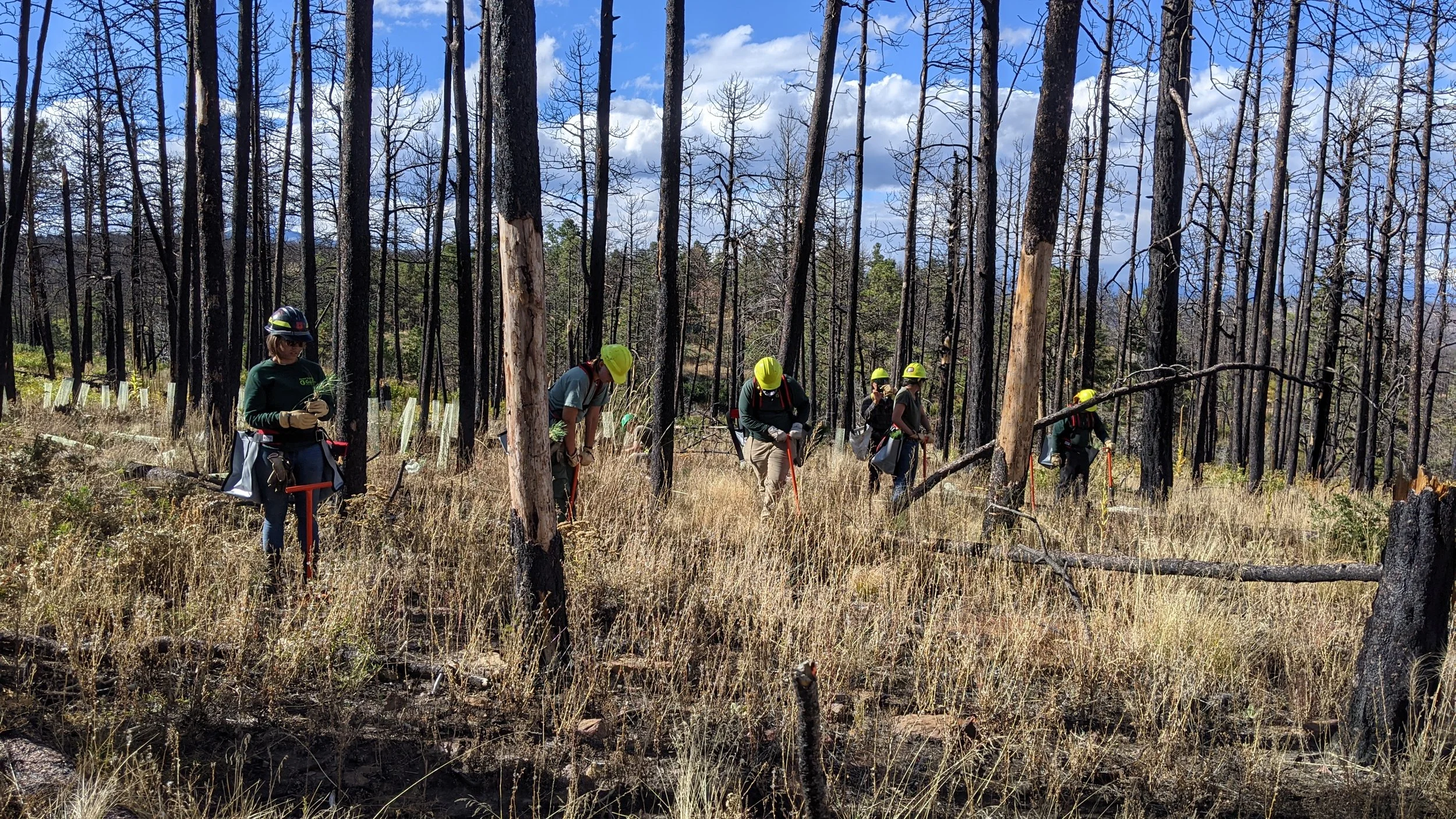
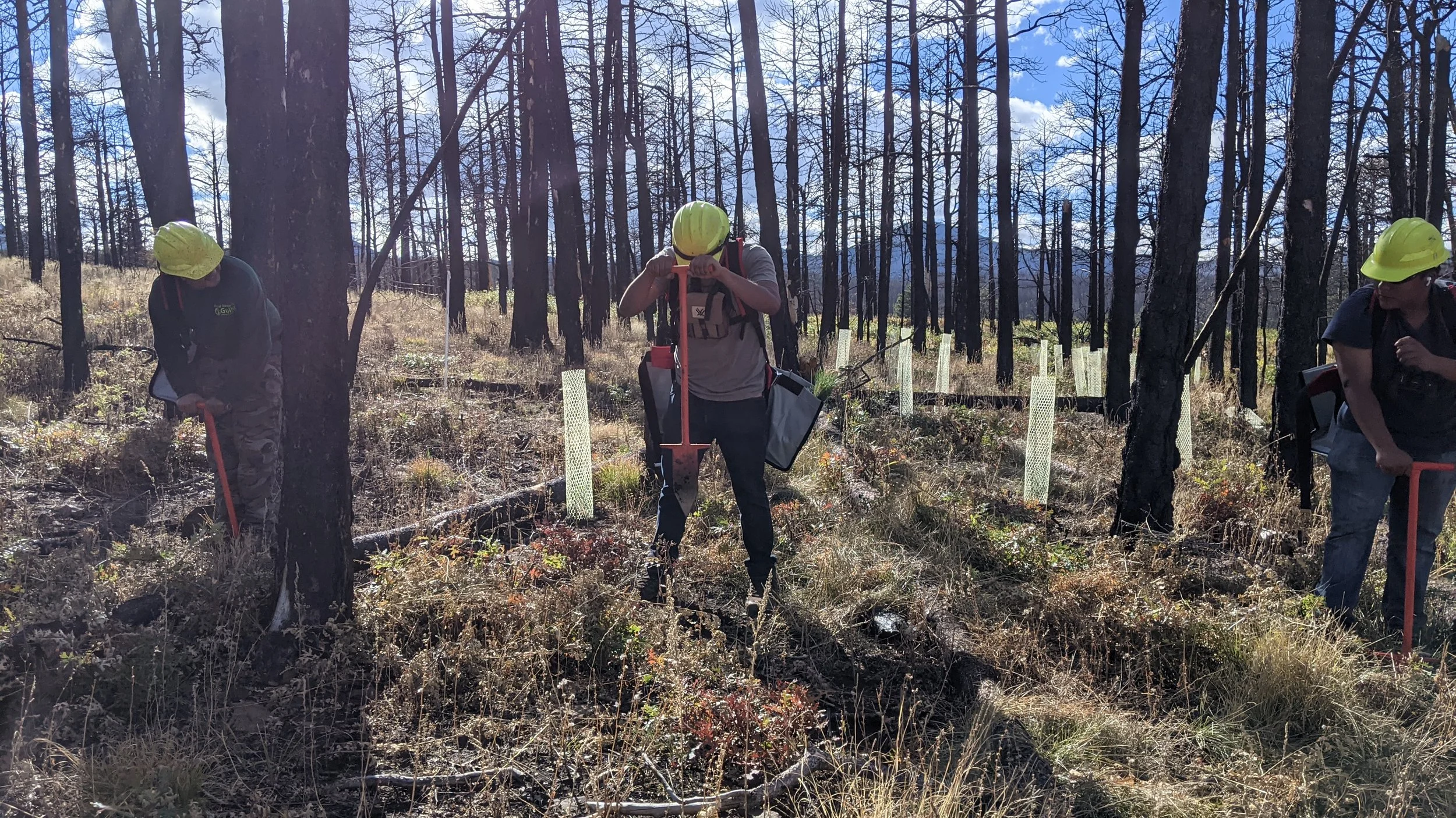
If you are not eligible to receive Emergency Watershed Protection Program funding, Hermit's Peak Watershed Alliance is also able to help with post-fire remediation work. We can bring technical expertise, materials and volunteer crews to projects such as seeding, erosion control and the slowing of potential flood waters. If you would like to schedule a site visit, please email us at hpwa@hermitspeakwatersheds.org.

Emergency Conservation Program

In addition to the NRCS EWP Program, there are other programs to assist producers during times of drought or wildfire. The FSA will soon announce a sign up period for the Emergency Conservation Program (ECP) to assist landowners with fire and flood related damages such as broken fences, ash and silt on lands, etc. Stay tuned for more updates.

Producers in Colfax County are eligible to apply for 2022 Livestock Forage Disaster Program (LFP) benefits on native pasture. LFP provides compensation if you suffer grazing losses for covered livestock due to drought on privately owned or cash leased land or fire on federally managed land. County committees can only accept LFP applications after notification is received by the National Office of qualifying drought or if a federal agency prohibits producers from grazing normal permitted livestock on federally managed lands due to qualifying fire. 

You must complete a CCC-853 and the required supporting documentation no later than January 30, 2023, for 2022 losses. For additional information about LFP, including eligible livestock and fire criteria, contact the Colfax County USDA Service Center at 575-445-9471 or visit fsa.usda.gov.

Potential applicants should be aware that they need to have farm records established at the Farm Service Agency (FSA) to be eligible to apply for the the above FSA programs. The NMAA can provide technical assistance with the sign up process. For more information, contact serafina@lasacequias.org.

Funding for Community Organizations Supporting Recovery

The Santa Fe Community Foundation is pleased to announce that they are now accepting applications for wildfire relief funding through the SFCF Community Resiliency Fund and the All Together NM Fund, respectively. New Mexico nonprofits and federally-recognized tribes are encouraged to apply today. Applications will be reviewed on a rolling basis and all funding will go toward core operating support.

For more information, click here.

Donate to Support those Affected by the Calf Canyon/Hermit’s Peak Wildfire

If you have not been personally affected by the Calf Canyon/ Hermit’s Peak wildfires and you want to support those in need, please consider donating to local organizations.

Click here to learn more.

Wildfire Wednesday #87: Reforestation

New Mexico has a long path of wildfire recovery ahead. Those affected can learn more about what post-fire recovery looks like by visiting the After Wildfire (afterwildfirenm.org) website.


Happy Wednesday, Fireshed!

We hope you enjoyed the cool weather over the weekend before things heat up again. With many fires still burning across the state, natural resource managers are starting to think about what comes after the flames. In some areas this may mean post-fire debris flow and flooding mitigation, hillslope stabilization and erosion reduction, or road and trail treatments. For those areas which were burned at high-severity and no longer have live “seed” (producing) trees on the landscape, post-fire treatments may include manual reforestation.

Today’s Wildfire Wednesday features:

  • The need for reforestation

  • Engineering climate-resilient trees

Best wishes,
Rachel


The Need for Post-fire Reforestation

What is it and why should we intervene?

Reforestation is defined as “the action of renewing forest cover (as by natural seeding or by the artificial planting of seeds or young trees)”. In New Mexico and beyond, private, university, state, and federal research centers and companies are working to collect tree seeds, grow seedlings in greenhouses and fields, and plant those baby trees in deforested areas.

Climate change-driven wildfires are trending toward burning bigger, longer, and hotter than in our recorded history. Larger portions of these fires, driven by their self-made weather systems, are also burning at high-severity, killing vast swaths of trees and understory vegetation and scorching the soil and the landscape. Because of the damage and the lack of live seed trees, sometimes for miles, these scarred landscapes are susceptible to ecosystem type shifts, meaning that a place which was once a forest is susceptible to not being able to come back as a forest. This is where land managers who recognize the ecological, social, cultural, and inherent benefits of forests step in.

Where does reforestation start?

Imagine walking through a green healthy forest, tall trees with thick branches reaching for the sun above you, squirrels scampering up the trunks and chirping to one another as they look for pine cones. This is where reforestation begins, in this existing mature forest. Fresh cones with a hearty bank of seeds inside will be collected from these trees and taken back to a nursey where they will be tested for viability, labeled, stored, and eventually germinated and grown into seedlings in greenhouses. Researchers like Owen Burney with New Mexico State University’s Forestry Research Center conduct targeted collection of seeds to source them from the healthiest trees growing on hot and dry southern slopes, trees which already show the most promise of being able to survive in a hot and dry future. These researchers may subject the baby trees to additional environmental stress in their first year of life, withholding water to encourage the trees to develop drought-tolerance. The seedlings will be tended to and grown in the batches of tens- to hundreds-of-thousands. Read more about this type of engineering.

Trees may be shipped as bare root or containerized “plug” seedlings. Illustration courtesy of Utah State University.

Once the trees are old enough to plant, typically 1-3 years, they will be packaged up in their small containers or dirt plugs and transported to the field site for manual planting by skilled forestry workers carrying a specialized shovel and up to 100 baby trees at a time in their hip bags. Prior to planting, however, the field site needs to be selected and prepared.


Building a Stronger Future Forest

Engineering climate-resilient forests means picking the right place for them to grow.

Shaded drainages and cool northern slopes can serve to provide additional resources and favorable conditions to newly-planted tree seedlings.

Selecting a site for reforestation starts with the question: what is the objective? Foresters think on the scale of hundreds of years, knowing that the trees they hope to plant may not be mature seed-producing forests until long after they’re retired. With this in mind, foresters need to be able to picture the future forest which will meet their objectives and then plant to create that forest. For climate-resiliency, site selection considerations might include finding areas which are going to be shadier, cooler, and wetter than the surrounding landscape. Called microclimates, these areas retain soil moisture and relative humidity which will lessen the amount of environmental stress on the trees, allowing them to grow quickly and become established. Such sites might exist on north-facing slopes and in drainages or other low spots. The process of planting in clumps and focusing reforestation efforts in these favorable microclimates is called nucleation, the goal of which is to create a seed-producing cluster of trees which will then be able to naturally reforest the surrounding area (INSERT PHOTO OF REFUGIA SITE). This approach to artificial reforestation focuses time, effort, and money on areas which are most likely to yield success. As one article in the Scientific American put it, “Southwest forest experts have spent years devising ways to outsmart climate change and give these forests a fighting chance.”

Giving the trees their best chance.

Brush, such as this thicket of Gambel Oak, must be cleared prior to planting to give tree seedlings their best chance.

After the site selection is complete, land managers need to prepare the area for planting. Following a fire which burns at high-severity, the soil is often scorched and scarred with much of the healthy organic material burned away. This soil is susceptible to erosion, degradation, debris-flows, and landslides. Land managers may work to stabilize slopes with directional felling of fire-killed trees and ground cloth, prepare drainages for flooding with weirs, and ensure that the baby trees they are preparing to put in the ground will not be buried, desiccated, or swept away in a debris flow. Small shrubs and bushes such as oak also regenerate quickly in fire scars and can out-compete the baby trees, requiring brush removal prior to planting.

Planting itself is a team effort and a labor of love. Artificial planting of container trees and plugs is done by hand by folks walking out, finding a suitable spot which will offer the tree some shelter and precipitation retention as it grows, and digging a deep hole in which to plant that tree, roots all pointing down, before covering it back up and moving on to the next tree. Crews can plant thousands of trees in a day, reforesting the landscape with 10-inch-tall sprouts of hope. Read more about the work of NMSU and the Forest Stewards Guild planting on the Philmont Scout Ranch here.

The fall 2021 Forest Stewards Youth Corps crews work to plant seedlings in an experimental reforestation project with New Mexico State University.

FSYC crews work to plant trees in a fire scar on Philmont Scout Ranch.

Planting seeds of hope.

Hope is ultimately what artificial reforestation boils down to – the hope that these trees will survive, thrive, be resilient against the many threats of climate change and drought, and grow into the future forests of the Southwest.

Learn more about reforestation in this article about reforesting the Giant Sequoias.