Coalitions and Collaboratives Training Opportunity, November 4-5, 2023

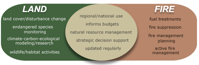
Two trainings associated with the 6th National Cohesive Wildland Fire Management Strategy Workshop, taking place November 6-9, 2023, are available through Workshop partner Coalitions and Collaboratives (COCO) and the USDA Forest Service.

When: Saturday and Sunday, November 4-5, 2023, 8am-4pm
Where: Eldorado Hotel, 309 W San Francisco St, Santa Fe, NM 87501
Cost: free to participate even if participants are not attending the Nov. 6-9 Workshop. Pre-registration is required.
How: email event organizers to register for the trainings using the button below.

PRE-REGISTER FOR THE TRAININGS
Learn more

Training #1: Community Wildfire Mitigation Best Practices Training 2-day short course

Community Wildfire Mitigation Best Practices (CW-MBP) is designed for current or future mitigation specialists, wildfire program leads, and others working with residents and their communities to reduce wildfire risk. CW-MBP training concentrates on science, methods, and tools to help you engage communities and residents while also helping you to eliminate ineffective practices.

Participants should come with a basic understanding of wildfires, how structures ignite, and vegetation management practices. The course assumes you know how to mitigate, but are seeking ways to engage your community. In this workshop, you will work through some of the greatest challenges facing our wildland-urban interface communities with a focus on how to increase engagement with residents and partners. The course will help you break down ineffective practices to make space for the more effective ones with a focus on on-the-ground mitigation activities.

Training #2:  Leading the CWPP Process – Learn how to lead the Community Wildfire Protection Planning process

Over two days, you will learn and practice how to facilitate a CWPP process and leave with templates and access to coaching.

Participants will learn about:

  • Mapping the process of CWPP development

  • Assessing local risk with everyday tools

  • Gathering community input

  • Prioritizing treatments with partners

  • Creating and implementing an action plan

Participants will receive:

  • Ready-to-use CWPP document template

  • Individual coaching after the class

  • Community assessment, survey, and outreach templates

Wildfire Wednesdays #122: LANDFIRE data and planning

Wildfire Wednesdays #122: LANDFIRE data and planning

Hi Fireshed community,

As wildfire frequency and severity continue to increase, we must be strategic in where and when we complete forest restoration and wildfire risk reduction work. As Forest Service chief Vicki Christiansen put it, '“instead of random acts of restoration, we must share decisions and place treatments where they can produce desired outcomes at a meaningful scale.”

To support strategic planning for wildfire risk reduction, we must use the best available data for the biophysical conditions within our planning areas. One of the most commonly used data sources for planning fire and forest management projects, is LANDFIRE data. Our planning and modelling for fire and forestry projects is limited by the quality of the LANDFIRE dataset. With this in mind, this week’s Wildfire Wednesdays will focus on sharing information about how we can improve the quality and accuracy of the LANDFIRE dataset by providing input for the 2023 update that is happening now.

This Wildfire Wednesday’s includes:

  • An overview of LANDFIRE data

  • Information about how to provide updates to the LANDFIRE dataset

  • Wildfire Risk to Communities - a user-friendly tool for LANDFIRE data

  • A webinar about how LANDFIRE data is used for modelling

  • General updates and opportunities

Best,
Gabe

LANDFIRE Overview

LANDFIRE data is used to establish wildfire risk for ranking funding proposals, insurance industry evaluations of risk, fire management planning, and more. This dataset is behind much of the work we do and it is important that we understand it.

LANDFIRE (LF), Landscape Fire and Resource Management Planning Tools, is a shared program between the wildland fire management programs of the U.S. Department of Agriculture Forest Service and U.S. Department of the Interior, providing landscape scale geo-spatial products to support cross-boundary planning, management, and operations.

LF data characterize the current and historical states of vegetation, fuels, fire regimes, and disturbances. LF produces a comprehensive, consistent, scientifically credible suite of more than 25 geospatial layers, a reference database, and a set of quantitative vegetation models at a national extent. LF data supports landscape assessments, analysis, and natural resource management. LF supplements and assists modeling of fire behavior and effects.

Update LANDFIRE Dataset

LF has transitioned to annual updates and needs as much time as possible to process data. LF is asking for data to be submitted or available in database systems by October 31st. Please make every effort to have your FY 2023 data accessible to LF by October 31, 2023. Data accessibility may include entering data into online databases/Systems of Record (SOR) so it can be obtained by LF. Data submitted after the deadline will be used if schedules allow. All data contributions must meet LF requirements.

The primary focus of this data call is to collect FY 2023 disturbance and treatment activities. To make annual updates possible LF is asking for data from the fiscal year which runs from 10/01/2022 – 09/30/2023. LF now requires disturbance/treatment date or fiscal year to be included with your data submission,. This will ensure your data are processed correctly. The secondary focus is to collect vegetation/fuel plot data. LF also welcomes feedback on current products.

LF needs your help to collect four types of data:

  • Disturbance/Treatment polygons: Disturbance and treatment polygons are first priority data for updates (LF 2012, LF 2014, etc.) and are processed and maintained in the LF Events Geodatabase.

  • Vegetation and Fuel Plot data:Vegetation and fuel plot data are the first priority data for mapping (LF c2001 / LF Remap) and are processed and maintained in the LF Reference Database (LFRDB)

  • Invasive Species Data: LF is accepting submissions of polygon or plot based invasive species data.

  • Lidar Data Lidar data are first priority data for mapping (LF Remap) and will be used to develop vegetation structure models.

  • Feedback on LF products: Feedback is secondary priority data for updates and remaps.
    Submit feedback through the LF Help Desk.

For data submission, questions, or you are aware of other data sources, contact:

Brenda Lundberg
LANDFIRE Reference Data Administrator
blundberg@contractor.usgs.gov

Using LANDFIRE Data

Not everyone needs to have GIS abilities to use LANDFIRE data to understand and explore their wildfire risk. To make the dataset more accessible, the USDA Forest Service created the Wildfire Risk to Communities tool.


Wildfire Risk to Communities is built from nationally consistent data, including:

  • Vegetation and fire-behavior fuel models from the interagency LANDFIRE program

  • Topographic data from the United States Geological Survey

  • Historical weather patterns from the National Weather Service

  • Long-term simulations of large wildfire behavior from the USDA Forest Service

  • Community data from U.S. Census Bureau and Department of Energy

Upcoming Events and Opportunities

Webinars

SWFSC: Overview and Verification of LANDFIRE Fuels: 2022 Cooks Peak Fire

Nov 8, 2023 12:00 PM  MT

A practitioner-oriented overview of LANDFIRE with a focus on fuels and how they react to modeling techniques. The subject area of discussion will be the 2022 Cooks Peak fire located in northern New Mexico. This webinar will be technical in its application and may offer insights for both beginner and advanced LANDFIRE users.

Presenters: Tobin Smail, LANDFIRE Next Gen Fuels Lead, USFS Rocky Mountain Research Station Fire Modeling Institute; and Charley Martin, LANDFIRE Fuels, TSSC Contract USGS/KBR

Register


FACNM - Fire, Forests, and People in the Jemez Mountains, NM: The Long View from Tree Rings and Archaeology

Nov 14th, 12:00 PM MT

In this webinar from the Fire Adapted New Mexico learning network, presenter Dr. Thomas Swetnam discusses the long view on fire, forests, and people in the Southwest through the lens of tree rings (dendrochronology) and archaeology. Although the past is not a perfect guide for the future, the history of people, forests and fires in the Jemez Mountains provides useful insights for restoring and living within resilient forest landscapes today.

View the webinar by registering through Zoom or by joining through Facebook Live on November 14 at 12:00pm.

Register

Job Opportunities

State Forestry Division is hiring two full-time year-round Wildland Fire Hotshot Crews

Applications for hotshot crew superintendent are being accepted now.

Click Here to Apply

The Forest Stewards Guild is hiring a Watershed Restoration Manager in the SW

Applications for the manager are being accepted now.

Click here to apply


Wildfire Wednesdays #121: Understanding Past, Present, and Future Fire Patterns Through Tree-Ring Fire-Scar Analysis

Hello, Fireshed readers!

My name is Dayl Velasco. I’m a project coordinator at the Forest Stewards Guild and the newest contributor to the Fireshed blog. Much of my work revolves around fire, from assisting with prescribed burns to collecting data on forest health pre- and post-thinning and burning to measure landscape resilience, and I’m excited to continue working in this realm as I help to coordinate this publication. Nice to meet you!

Today’s Wildfire Wednesday focuses on how scientists use the life history of fire scarred trees that is recorded in their rings (seen in a crosscut of wood) to understand historic fire regimes and date specific fire events. You’ll be introduced to the North American Tree-Ring Fire-Scar Network, which was compiled in 2022 and contains over 37,000 sampled trees across North America. You’ll learn about work closer to home with a brief overview of New Mexico’s own Jemez Mountains Tree-Ring Lab and the research they do and the story of a recently analyzed old ponderosa pine that fell near Jemez Springs and offered its tales up to science, to be absorbed into the tree-ring network. Throughout, we’ll keep in mind how this research guides our work to build resilience in our forests and communities.

This Wildfire Wednesday features information on:

  • Understanding past, present, and future fire patterns through tree-ring fire-scar analysis

  • Close to home: the largest mountain-range fire scar network in North America

  • Applying the science to FACNM

  • Resources and Upcoming Opportunities

-Dayl


Understanding past, present, and future fire patterns through tree-ring fire-scar analysis

Back to basics: what is tree ring analysis?

Ellis Margolis cross dates an old piece of ponderosa pine from the Tesuque watershed outside of Santa Fe, New Mexico. Collin Haffey, USGS Public domain.

In a world where wildfires are increasing in severity year-after-year, driven by climatic changes and increased fuel loads as a result of over 100 years of fire suppression, we know that fire is a force we must learn to live with. This is especially true in the southwest’s fire-adapted forests. As we move toward adaptation ourselves, it is helpful to ground our current understanding of wildfire in the context of centuries-old fire regimes. So, how do we build this historical context?

This is where the trees and the scientists who study them come in. First, some basics: if you’ve ever seen a cut tree stump, you’ve probably noticed that the top of a stump has a series of concentric rings. These rings can tell us how old the tree is, and what the weather was like during each year of the tree’s life. The light-colored rings represent wood that grew in the spring and early summer, while the dark rings represent wood that grew in the late summer and fall. One light ring plus one dark ring equals one year of the tree’s life (NASA, 2017). Dendrochronology is the study of these tree rings to answer questions about the natural world and the place of humans in its functioning.

Trees contain immense histories in their rings and dendrochronologists understand how to read and interpret these records. The information preserved in tree-ring growth records, from fires to weather conditions, reads like a history of the land where they grew for their entire life span - that can be over 1,000 years for some trees! Historical environmental conditions are expressed as wide or narrow rings or changes in growth patterns. Wide rings indicate years of plentiful moisture while narrow rings indicate drought. Ring width can also be correlated with temperature, especially in cooler climates and higher elevations. Learn more about tree rings from the Laboratory of Tree-Ring Research.

Fire scar position and seasonality within the tree-ring and corresponding calendar year.

When a fire moves through a forest, some trees may burn and experience damage to their cambium - or living tissue just below the bark - but not die. This results in a fire scar, where a tree produces sap to cover its scorch wound. As the tree heals and grows around the scorch wound, these scars remain visible within the growth ring of the year in which the fire occurred. It’s important to note that if a tree has recorded multiple fire events, the fires it experienced were likely low- to moderate-severity, or just intense enough to create a scar but not enough to kill the tree. High-severity fires are traceable through tree rings as well, but scientists depend on a record from trees that were able to survive on the less intense outer edges of these fires since trees in the middle are often casualties of the blaze. A robust dataset of tree-ring fire scars, taken from a broad area, can tell us the exact year and season a fire burned, its severity and size, and overall fire frequency from centuries before modern records began.

This field fire history reconstruction through tree-ring fire scars is called Dendropyrochronology (for all you logophiles out there). Read a more in-depth description of fire history reconstruction here.

The North American Tree-Ring Fire-Scar Network

Yellow dots represent the more than 2,500 fire-scar sites that currently make up the network across North America. Credit: Ellis Margolis, USGS.

The North American Tree-Ring Fire-Scar Network was formed in 2022 and compiles tree-ring data from more than 2,500 sites across the entire North American continent. Through the network arise new opportunities to understand the influences of climate, humans, and land use on past, current, and future fire regimes.

The team that undertook the monumental task of analyzing data from more than 37,000 fire-scarred trees across North America found evidence of historical low-severity fire in all but two ecoregions of the continent. This evidence was often found in areas that have not burned for one hundred years or more due to anthropogenic fire suppression.

The network also shows that human influence strongly impacts fire regimes. This is clearly demonstrated at the border of the United States and Mexico, where fires stopped being recorded in the tree ring record on the U.S. side around 1900 as suppression became the norm (creating the fire deficit that helped set the stage for modern megafires), but on the other side in northern Mexico fires continued to burn, be recorded in tree rings, and maintain resilient ecosystems to the present day.

Read more about the North American Tree-Ring Fire-Scar Network in this article.


Dendropyrochronology Close to Home

The largest mountain-range fire scar network in North America: fire regime reconstruction in the Jemez Mountains

The tree-ring fire scar network in the Jemez Mountains covering >300,000 acres.  Colored symbols represent individual fire-scarred trees from different collections over 30 years. Public domain.

Let’s zoom back in on the Southwest. There is a long history of tree-ring research here, with plentiful old trees, aged tree stumps, and remnant wood present in archaeological structures. Over the past 30 years, New Mexico researchers have built the largest tree-ring fire scar network for a single mountain range - the Jemez Mountains - in North America. The Jemez network currently includes 1,343 trees and 9,014 fire scars with these numbers ever-increasing. The Jemez Mountains Tree-Ring Lab has many concurrent research projects across the Southwest in service of the overarching goal of researching the effects of climate variability on forest ecology, fire ecology, and ecohydrology. Locally, in the Jemez mountains, the lab is working to understand the area burned since 1600 CE over a 300,000-acre landscape. These fire reconstructions allow scientists to place the large fires of recent years into a historical context.

Tree Ring Analysis from Horseshoe Springs

Brent Bonwell cutting the cross section.

Shortly after the completion of a forest thinning treatment near Jemez Springs, Horseshoe Springs community member Brent Bonwell noticed that a large dead ponderosa pine had fallen, and upon closer observation he saw a well-defined fire scar at its base.  He wondered if it would be possible to learn about the fire history of the area by cutting a cross section from the tree and having the tree rings dated to determine exact years of fire events. The tree had seen more than the typical number of fire events in its lifetime, with 17 total scars recorded. 13 of the 17 fire events coincide with some of the largest fires recorded among other fire scar sampling sites in the Jemez Mountains. The tree showed no fires recorded after 1900, reflecting the systematic fire suppression that began at the turn of the 20th century. Read the full report written by Thomas Swetnam of the Jemez Mountains Tree-Ring Lab.

Applying the science

How fire history guides our work with Fire Adapted Communities

Ponderosa pine forest after thinning and burning.

The research being done at tree-ring labs across the world focuses on the interactions between humans, ecosystems, fire, and climate. Many studies are designed to inform forest and fire management decisions by enabling the comparison of our present fire regimes to centuries-long records and historic regimes. In populated areas where communities and their water supplies are potentially threatened by high-severity fires, science-management partnerships use tree ring research to guide land management decisions and goals, with a prime local example being the landscape-scale work of the Greater Santa Fe Fireshed Coalition. Historical reference points provided by tree ring collections and data give managers examples of more resilient forest conditions and fire regimes. Managers can in turn work toward these ideal conditions when acting to restore forests and fire regimes and mitigate wildfire risk in our wildland-urban interface. Every little bit of ecologically-informed forest restoration, whether it's happening on thousands of acres of federal land or in your back yard, is a step in the direction of protecting communities, returning ecosystem functions and biodiversity, and addressing climate change.


Resources and Upcoming Opportunities

In-person Learning

Applications due October 15th: Fire Leadership For Women (FLFW) 20-Day Session

The National Interagency Prescribed Fire Training Center (NIPFTC) is hosting three training sessions for women in wildland fire management. Participants will experience 10 to 12 days of hands-on burning in complex situations such as wildland urban interface, various fuel types, and will work for several different agencies with unique management objectives. Participants will gain up-to-date knowledge on prescribed fire safety, prescribed fire planning, smoke screening tools, monitoring, and current fire policy.

January session: 01/07/2024 through 01/26/2024

February session: 02/11/2024 through 03/01/2024

March session: 03/10/2024 through 03/29/2024

Learn more about fire leadership for women

October 26, 6:00pm, Taos, NM: Future Forests- Living with Fire

Join The Nature Conservancy for a conversation with a panel of experts to talk about the future of forests and how we can manage our forests better in New Mexico. TNC’s Forest and Watershed Health Manager Matt Piccarello will moderate this session that will include an opportunity for audience members to ask questions of the experts.

Webinars

FACNM Fall Webinar Series: Prescribed Fire in New Mexico

FACNM is hosting speakers from across the state (and the country) this autumn to talk about many different aspects of prescribed fire!

First up, join us on October 11th to hear Dr. Makoto Kelp present research that indicates that prescribed fire implemented in priority areas in the West may lower the likelihood and severity of future wildfire smoke during a joint FACNM-SWFSC webinar. Register Now!

On November 14, Dr. Tom Swetnam will discuss research showing that traditional Indigenous fire management may have interrupted the connection between climatic conditions and wildfire behavior at a local level.
To close the series, on December 7, Sam Berry and Brian Filip will discuss implementation of prescribed fire in the state of New Mexico, including the new Prescribed Burner Certification Program and All Hands All Lands. Download the flyer to learn more.

Keep an eye on the FACNM Events page for November and December webinar registration announcements!

Additional Reading and Resources

3 Things Outdoor Recreationists Need to Know About Wildfire Outdoor Alliance article on how recreationists can support a more fire resilient future through education and support for policy reform.

WildfireSAFE provides simplified access to an advanced suite of fire weather and products to support fire management decisions. Visit the website to view weather & potential for wildfires across the nation. 

Wildfire Wednesdays #120: Recognizing Community Distinctness in Fire Adaptation and Preparation

REPOSTED to highlight Resources and Upcoming Opportunities

Hello Fireshed folks!

It may seem like common sense, but different communities perceive wildfire, wildfire risk, resilience actions, and personal wildfire risk differently. Even within a small town, individual neighborhoods likely vary wildly in their perception of and readiness for wildfire. As fires grow more extreme across the West and transition from wildlands to widespread house fires more often, effective implementation of wildfire preparedness strategies is becoming more important. Today’s blog provides information on the importance of tailoring fire prevention and preparedness messaging to individual communities to address their unique needs and barriers.

This Wildfire Wednesday features information on:

  • Resources and upcoming opportunities

  • How perceptions of fire risk vary across communities

  • The importance of tailoring fire education programming

Take care and enjoy the autumn equinox!
Rachel


Resources and other Opportunities

Funding opportunities

FACNM Microgrants Round 2 - Closes September 30!

The microgrant program from FACNM provides up to $2,000 for activities related to community fire preparedness, including community chipper days, educational events, meetings, public thinning demonstrations, and more! Applicants must be a FACNM Member or Leader (take 10 minutes to apply to join) and can apply for funding through a short Google Forms questionnaire. Learn more about the microgrant program and read about past recipients.

APPLY FOR A FACNM MICROGRANT!

The Ready, Set, Go! Program, provided by the USDA and managed by the International Association of Fire Chiefs, is accepting proposals from fire departments across the country to fund on-the-ground fuels reduction projects in communities. Eligible projects include Thinning, limbing, mastication; Grazing programs; Chipper days; Transfer of slash and fuels to a burn or disposal site; Development of a burn pad or debris collection site; and Defensible Space Projects. Applicants must be Ready, Set, Go! program members (join for free). Learn more about the funding opportunity.

Learn more
APPLY FOR FUNDING

In-person learning

September 30, 9:00am - 1:00pm, Ojitos Frios, NM: Living with Fire - Protecting your Home in the Next Fire
Querencia in Action is partnering with Luna Community College and New Mexico Forestry Division to present a free workshop on home hardening techniques such as pruning, limbing, tree thinning and creating Survivable Space. Click on the image to learn more.

October 26, 6:00pm, Taos, NM: Future Forests- Living with Fire
Join The Nature Conservancy for a conversation with a panel of experts to talk about the future of forests and how we can manage our forests better in New Mexico. TNC’s Forest and Watershed Health Manager Matt Piccarello will moderate this session that will include an opportunity for audience members to ask questions of the experts.

EMAIL THE ORGANIZER TO REGISTER!

Webinars

FACNM Fall Webinar Series: Prescribed Fire in New Mexico
FACNM is hosting speakers from across the state (and the country) this autumn to talk about many different aspects of prescribed fire!

First up, join us on October 11th to hear Dr. Makoto Kelp present research that indicates that prescribed fire implemented in priority areas in the West may lower the likelihood and severity of future wildfire smoke during a joint FACNM-SWFSC webinar.
On November 14, Dr. Tom Swetnam will discuss research showing that traditional Indigenous fire management may have interrupted the connection between climatic conditions and wildfire behavior at a local level.
To close the series, on December 7, Sam Berry and Brian Filip will discuss implementation of prescribed fire in the state of New Mexico, including the new Prescribed Burner Certification Program and All Hands All Lands. Download the flyer to learn more.

Register for the October webinar or watch it live on Facebook and keep an eye on the FACNM Events page for November and December webinar registration announcements!

Fire Risk: Perceptions and Preparedness

How risk perception varies across communities

(Note: much of the following comes from Actionable social science can guide community level wildfire solutions, a research article recently published in the International Journal of Disaster Risk Reduction.)

The Marshall Fire in Colorado; photo by RJ Sangosti via the Denver Post.

Devastation of communities due to wildfires is an important issue. Extreme wildfires, which have become more common in recent years, threaten the economic and social resilience of communities located in the wildland-urban interface (WUI) - where wildland fuels meet residential development. A wildfire with extreme behavior and impacts can destroy a high proportion of homes, associated infrastructure, and the social fabric of a community. As recent wildfires, such as the Lahaina fire in Maui, Hawaii, have shown, one critical aspect of WUI fire disasters is that they have the potential to become a home ignition problem - where the fire transitions from burning natural fuels such as grass and trees to burning human-built structures. These fires have the capacity to become mass conflagration events, with fire jumping from one house to the next.

Wildfire practitioners often know, based on their personal experience and knowledge of an area, that education efforts should be differentiated across the communities they serve. However, those tasked with getting in front of the problem by promoting mitigation and preparation rarely have the data they need to move beyond a one-size-fits-all approach. Social research shows that WUI communities and their residents vary in their relationships to wildfire and their landscapes. While distinct communities, even if they are geographically close, may exhibit similar attitudes toward wildfire in general, there are often significant differences in their perception of community fire risk - and in the types of fire preparedness educational materials that are most effective in informing and motivating residents and homeowners to take action.

Even when clear guidelines about what residents can do to reduce the ignitability of their homes is presented, implementation of such guidelines is inconsistent across the WUI.

The importance of tailoring fire education programming

In places where mitigation of wildfire risk on private property is largely voluntary (such as Canada, the US, and Australia), community-based wildfire programs often play a key role in educating and motivating residents to mitigate risk. In addition to encouraging wildfire risk mitigation, these programs support residents’ efforts to prepare for a wildfire event through education, building social cohesion, and financial and logistical assistance with implementation.

Differences in fire perception amongst distinct communities mean that fire adaptation programs and community leaders who wish to enact meaningful change need to tailor wildfire preparation and mitigation programs to the local context. To customize the information shared with residents appropriately, program leaders first need to understand local perceptions of fire, such as what the community views as necessary or effective risk mitigation behaviors, common barriers to mitigation, and community communication preferences.

So, how do program managers and community leaders begin the process of understanding local perceptions, and from there craft outreach efforts, tangible assistance, and educational materials that speak to localized risk and needs? Community surveys, such as those conducted by WiRē – Wildfire Research, can provide locally scaled data to develop richer, more actionable insights for wildfire education programs. This type of social research seeks to measure how WUI residents engage with wildfire risk and often includes broad explorations of demographic characteristics, social profiles, and processes, including wildfire attitudes and perceptions, the role of social capital and adaptive capacity, and behaviors to mitigate fire risk.

When those in leadership positions have a baseline understanding of distinct communities, they can begin to identify gaps in preparedness and blind spots in community perception of risk, then develop programs that provide the resources to fill those gaps. Imagine that homeowners and residents in a neighborhood that abuts National Forest System lands view their wildfire risk as low, but fire managers or county fire department personnel perceive their risk as high due to the likelihood of spread from the forest to houses. Developing an understanding of that community perception provides a roadmap for program managers to tailor their approach by presenting facts about actual versus perceived risk and offering options to increase resilience within that specific community. At their core, local education efforts seek to align resident expectations, and subsequent resilience actions, with the perspectives of wildfire professionals.

Wildfire Wednesdays #119: Managed Wildfire

Hello, Fireshed Folks!

Fire has always played a dual role in our planet's natural landscapes - an elemental force of destruction and a harbinger of renewal. Yet, within the smoky depths of this paradox lies a method of intentionally engaging with wildfire that has been honed and utilized by traditional communities, natural resources practitioners, fire managers, and others for the better part of a century. This technique has gone by many names but is now commonly known as "managed wildfire." In this week’s Wildfire Wednesday, we explore this practice, tracing its evolution, illuminating its significance, and recognizing the persistent place fire as a tool has and the role it will continue to play in our modern world. This post is based on a recent science synthesis on managed wildfire from the Southwest Fire Science Consortium.

Today’s Wildfire Wednesday features information on:

  • The concept of “managed wildfire”

  • How managed wildfire has evolved

  • Present use and benefits

  • The intersection of managed wildfire and climate change

  • Other resources, including microgrant opportunities, webinars, and more

—Alyssa


Defining “Managed Wildfire”

What is the fire response strategy?

Image courtesy of istock

"Managed wildfire" is a strategy for responding to naturally ignited wildfires which refers to the deliberate use of wildfire as a land management tool to meet objectives such as firefighter safety, resource benefit, and community protection. This approach recognizes that many ecosystems have evolved with fire as a natural ecological process, essential for maintaining their health and biodiversity. By strategically permitting some wildfires to burn under moderate conditions with close monitoring and layered containment plans, land managers can achieve vital ecological and social safety goals which are otherwise daunting in their scale and need. Similar to prescribed fire, managed wildfires help reduce the buildup of dense underbrush, dead vegetation, and overgrown trees which can otherwise fuel catastrophic blazes. Managed fires introduce diversity, called heterogeneity, to fire-adapted forests. They often burn in a “mosaic” pattern, meaning that some areas will burn at low intensity while others burn a bit hotter with corresponding differences in fire impacts and residual forest density. This fire management technique promotes the regeneration of fire-adapted plant species, enhances habitat diversity for wildlife, and contributes to overall ecosystem resilience.

Figure courtesy of University of Washington: “Wildfires as fuel treatments – burn mosaics and wildfire management

Embracing managed wildfire as a fire response strategy acknowledges the limitations and dangers of complete fire suppression: some fires which encounter forest conditions shaped by fire exclusion and an absence of land maintenance grow large, destructive, and dangerous to control, posing an elevated risk to firefighters, communities, and the environment. Balancing the art and science of fire management with the proven benefits of fire reintroduction offers a more sustainable and proactive way to mitigate future wildfire risks and live in fire-dependent landscapes.

Read more about wildfires as fuel treatments - burn mosaics and wildfire management.


Historical Use

Fire as an essential ecological process

Image courtesy of Josh Neufeld

Indigenous peoples across the globe have long been custodians of the land with practices and knowledge systems that incorporate fire as a fundamental element of land stewardship. In the West, indigenous communities coexisted with wildfire for centuries or millennia before Euro-American colonization. Fire has also been used intentionally to reenergize the land: promoting the growth of edible, medicinal, and materially useful plants; cultivating open landscapes for habitat diversity, grassland browse for wildlife species, and farmer settlements; fire hazard reduction around settled communities; and more.

Suppression as the default

Retardant drop in Carnuel, NM, 2022. Photo courtesy of Alex Poli.

By the 1890s, European settlement resulted in an emphasis on suppression of wildfires. This regard for fire as a destructive force which threatened resources is exemplified by the establishment of the U.S. Forest Service in 1905, whose founding mission was wildfire suppression to safeguard lives, property, and valuable timber. Over the next century, full suppression became the preeminent response to wildfire, albeit with outliers. Technological advances, including the development of fire retardants, improved fire engines, and incorporation of firefighting aircraft, significantly enhanced the ability to actively combat wildfires. This approach, paired with climate change and drought, contributed to ecological imbalances that we are now seeing play out across our forested landscapes.

Unintended consequences of fire suppression:

  • Ecological Imbalances: over time, wildfire suppression has disrupted natural fire regimes in numerous ecosystems. Fire is an integral part of many landscapes, playing a crucial role in maintaining ecosystem health and diversity. The absence of regular, low- to moderate-intensity fire has led to the accumulation of fuel (called “fuel loading”) and shifts in vegetation composition.

  • Increased Fire Intensity: these ecological imbalances have contributed to larger and more intense wildfires when they do occur. This intensification can render firefighting efforts more challenging and costly.

  • Budgetary Constraints: the costs associated with wildfire suppression have soared, straining the Forest Service's budget and diverting resources from other critical programs, including forest management and conservation.

  • Loss of Fire-Adapted Ecosystems: fire-adapted ecosystems, such as grasslands, savannas, and specific forest types, have shrunk in extent (conversion to other ecotypes) or experienced character change due to fire exclusion.

Fuel loading provides ample resources for future fires to burn hotter, faster, and more intensely. The increased heat and rate of spread generated by such fires can make them difficult to control, posing a significant threat to both the natural environment and human communities. This cycle of fire suppression leading to fuel accumulation leading to catastrophic wildfires can become self-perpetuating. As large wildfires devastate the landscape, the impulse to suppress wildfires becomes stronger. These fires can also create even more favorable conditions for future fires, as dead and downed trees remain primed for future ignition and burned vegetation may not be able to recover as quickly, leaving behind a landscape that is more prone to reburning.

Reintroduction through policy

Federal policies have undergone significant evolution over the years as our understanding of fire ecology and land management practices has deepened. The concept of managed wildfire was introduced and implemented in California in the 1916, but political pushback ended the program after only three years. The National Park Service introduced managed wildfire, then called “natural prescribed fire” or “natural fire management”, to select parks for use the backcountry in the 1960s. A change in wildland fire behavior in the 1990s caused federal agencies to rethink their approach to fire management, and in 1995 the U.S. Forest Service updated their policies to create space for managed wildfire as a response strategy. The federal Departments of Agriculture and the Interior, in 2009, asserted that “fire, as a critical natural process, will be integrated into land and resource management plans and activities on a landscape scale, and across agency boundaries”, and the National Wildfire Coordinating Group (NWCG) and National Cohesive Wildland Fire Management Strategy have since named managed wildfire as a legitimate approach to fire management.


Present Use

Aren’t we “managing” wildfire now?

Technically, yes, all wildfires are managed using a variety of response strategies. As specified by the Chief of the U.S. Forest Service in 2022, “every fire receives a strategic, risk-based response, commensurate with the threats and opportunities, and uses the full spectrum of management actions, that consider fire and fuel conditions, weather, values at risk, and resources available and that is in alignment with the applicable Land and Resource Management Plan.”

The shift in recent decades has been for the Forest Service and other land management agencies to acknowledge the importance of reincorporating fire into land management as an essential and natural ecological process. This is accomplished through prescribed burns and, when conditions are right and a natural ignition occurs in a suitable area, allowing some wildfires to burn without prioritizing full suppression as part of a managed wildfire approach. The goal of reintroduction, regardless of method, is the same: to harness the ecological benefits of fire while mitigating risks to communities, firefighters, and resources. This evolving approach represents a more holistic and sustainable way of responding to wildfires in the face of changing environmental conditions.

A little known but common response

While full suppression is still used as the primary fire response strategy, especially during the hottest and driest months of the year, managed wildfires are a commonplace occurrence on the landscape. The combined footprint of managed wildfires in the western contiguous United States covers an average of 268,000 acres annually, and managed wildfire has been a dominant fire response strategy in Alaska. A strategy other than full suppression is chosen more often later in the season, usually starting after dangerous wildfires have been contained and when managers know that a significant precipitation is likely in the next six to eight weeks. Because managed wildfires generally burn under cool, moist, and moderate weather conditions, they tend to exhibit low- to moderate-fire severity. A managed wildfire strategy is also more likely to be implemented when the fire in question ignites far from communities or other values at risk, is likely to remain small based on natural barriers or containment features, and presents as less complex, requiring the involvement of fewer firefighting agencies and resources. Detailed case studies of managed wildfire found opportunities and obstacles to the strategy were “strongly shaped by local interagency and cross-jurisdictional contexts” such as federal, state, and local policy, Forest Plans, internal agency directives and culture, operational concerns, and real or perceived internal and public support for the strategy.

Benefits of managed fire

Reburns: in general, wildfire has a moderating effect on subsequent fires. Studies have found that in the ten years following a wildfire, subsequent fires experience reduced severity. This is true of managed wildfires, which generally burn under more moderate weather conditions and contribute to variable fire effects and surface fuel reduction that can mitigate future fire risk.
Forest structure: managed wildfires are effective at reducing tree densities, although perhaps not enough to return forests to historic conditions. Even repeat fire entries with predominantly low severity effects are not as effective for bolstering forest resilience as a single managed wildfire with moderate severity effects.
Waterways: in addition to mitigating effects on future wildfires and positive effects on forest structure, bringing fire back to fire-adapted forests benefits streams and rivers, promoting healthy water systems and reducing drought-induced tree mortality.
Cost: when and where wildfires can be managed for resource and community objectives, studies have demonstrated they likely cost less than full suppression wildfires. Additionally, where managed wildfires reduce fuels, they may also reduce the risk and cost of responding to future wildfires that burn through the same area.

Figure comparing Managed Wildfire to Full Suppression Fire from the 2023 Southwest Fire Science Consortium Fact Sheet “Managed Wildfire: One fire response strategy’s history and use

Managed wildfires reengage the natural fire regimes that ecosystems evolved with, helping to reduce fuel loading, maintain biodiversity, and reduce the risk of catastrophic wildfires. By carefully planning and executing a managed wildfire, land managers can mitigate the long-term consequences of fire suppression policies, contributing to safer and healthier landscapes in the face of a changing climate.


Future Use

Facing the wildfire crisis

Increased management of wildfire for resource objectives will enlarge the area burned each year in the near term but will reduce the number of acres burned at high severity in the long term. Managed wildfire “can improve forest resilience and contribute to restoration efforts in fire-adapted forests,” but potential tradeoffs include increased smoke and declines in certain habitat types. Research comprehensively suggests that any long-term solution to the tremendous wildfire challenge facing communities and land managers across the western US will involve managed wildfire. Managing natural ignitions for resource and community benefit during moderate weather conditions offers hope for limiting future wildfire spread, reducing burn severity, and enhancing suppression effectiveness.

2016 Mormon Fire, Coconino National Forest. Photo courtesy of George Jozens, USDA Forest Service

An increase in the frequency and severity of managed wildfires will require careful risk management such as use of emerging fire modeling programs such as the Potential Operational Delineation (PODs) adaptive framework and clear communication with the public. Removing internal barriers, rethinking risk management, and reinvigorating the conversation around reintroduction of fire are logical and necessary next steps to increase utilization and facilitation of a restorative and cost-efficient forest management tool.

Managed fire and climate change

Incorporating the role of managed wildfires into the climate change resiliency conversation is crucial as we grapple with the far-reaching environmental transformations driven by climate change. These shifts encompass temperature variations, alterations in precipitation patterns, and increased frequencies and intensities of extreme weather events. These changes disrupt conventional ecological processes and render ecosystems more vulnerable to disturbances, including wildfires. As a result, understanding the significance of managed wildfires is pivotal in the context of climate change resilience. It underscores the dynamic nature of ecosystems and the necessity for flexible, responsive strategies. Raising public awareness about the ecological benefits of managed wildfires in the context of climate change resilience is equally vital. This can lead to greater support for burn programs and foster a broader understanding of the intricate relationship between fire, ecosystems, and climate change.

Managed fire research and factsheet

Other Resources

Grant opportunity

Photo from a green waste disposal event for the community of La Barbaria, made possible by Round 1 microgrant funding from FACNM.

Fire Adapted Communities NM is offering grants of up to $2,000 to network Leaders and Members seeking financial assistance for:

  • convening wildfire preparedness events,

  • enabling on-the-ground community fire risk mitigation work, or

  • grant proposal development to ensure the sustainable longevity of their Fire Adapted Community endeavor.

Proposals demonstrating community benefit or FAC capacity building are considered on a semi-annual basis; read about project successes funded by Spring 2023 - Round 1 microgrants. Grantees will be reimbursed for applicable expenses up to their awarded grant amount.

Learn more
Already a member? Apply for a grant

Webinars

Wednesday, 13 September at 12:00pm MDT: Grassification and Fast-Evolving Fire Connectivity and Risk in the Sonoran Desert
In the second webinar of a series on invasive grass-driven changes in dry desert systems, presenters will discuss their findings on fire dynamics in the 2020 Sonoran Desert Bighorn Fire near Tucson, AZ to better understand the changing nature of fire in desert systems which are increasingly experiencing conversion to grasslands.

REGISTER FOR THE SEPTEMBER WEBINAR

Wednesday, 11 October at 12:00pm MDT: Prescribed Burns as a Tool to Mitigate Future Wildfire Smoke Exposure
Tune in for a webinar co-hosted by FACNM and the SW Fire Science Consortium! This presentation will introduce research on how targeted prescribed burn treatments in heavily forested Western states may have an outsized impact on improving air quality forecasts for the entire western U.S. by reducing the likelihood of future wildfire smoke.

REGISTER FOR THE OCTOBER WEBINAR

Recent research

Planning for future fire resource needs: the Science You Can Use bulletin titled “Looking to the Past to Plan for Future Wildfire Response” focuses on how characterizing where firefighting personnel and equipment are coming from, both geographically and by managing agency, may help fire managers project how to fill future resource needs.

Read the paper

Giving Power to Communities for Fire Resilience: An Interview from the Fire Adapted Communities Learning Network dives into the importance of partnership, meaningful community engagement, and creating local intentional burn opportunities in order to foster community fire resilience.

Read the blog