Wildfire Wednesdays #111: Red Flag

Happy Wednesday, GSFFC community!

Screenshot of a weather application on phone with a blue sky background and a banner reading "red flag warning"

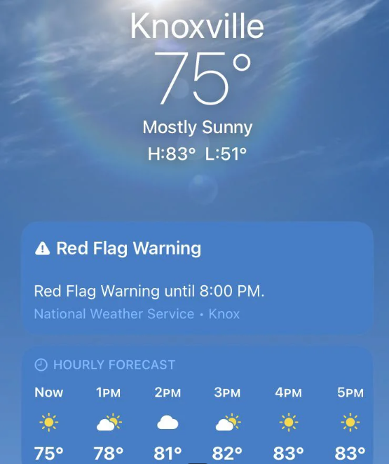
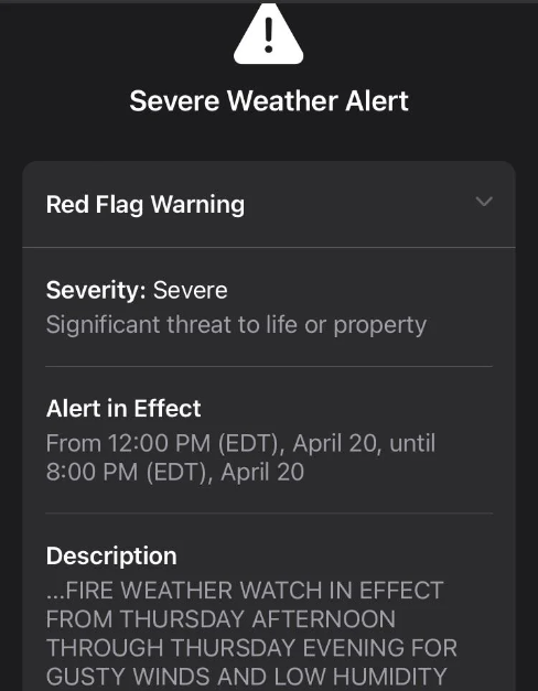
Imagine you’re sitting down to your first cup of coffee in the morning and notice that it looks a little windy outside. You pull out your smartphone and open the weather app to check the forecast. There, at the top of the application, is an alert which reads “Red Flag Warning” from the National Weather Service. What does that mean?

This week’s Wildfire Wednesday will break down severe summer weather alerts, what they mean for fire risk, and how to prepare for Red Flag days.

Today’s Wildfire Wednesday features:

  • What are Red Flag Warnings?

  • The geographic scope and learning more about Red Flag Warnings

  • Recommended actions on Red Flag days

Be well,

Rachel


Red Flag Warnings

What are they?

The origin of the name, Red Flag Warning, is a literal one, according to Tamara Wall of the Desert Research Institute: “If there was… high fire danger, local fire stations would go and run a red flag up the flagpole. It was a very visual, kind of pre-mass communications way to signal to people in the area that it was a high-danger day” (NPR, 4/14/23).

According to the National Weather Service (NWS), which issues these alerts in conjunction with local and state agencies, a Red Flag Warning is part of a weather forecast which indicates a local increase in fire danger risk in the next 12 to 24 hours. This increased risk is due to a combination of critical fuel conditions and critical weather conditions (warm temperatures, very low humidities, and strong winds). This means that if a wildfire starts, the conditions are right for it to spread rapidly and be difficult to contain. Red Flag Warnings differ in timing from a fire weather watch, which warns of the possible development of those conditions in the next 72 hours.

This combination of temperature, humidity, and wind conditions creates what is called critical fire weather. When you see a Red Flag Warning, that also means that critical fire weather is currently or will soon be occurring. The alert, whether online, on the news, or on your weather app, will usually indicate how long the Red Flag Warning is forecast to last. Fire management personnel take Red Flag Warnings into account and may respond by changing staffing numbers or preemptively moving resources into a certain region to be prepared for a potential ignition. During extended periods of high risk, local authorities may consider policy decisions like banning campfires or closing specific areas (see ‘What you should do’, below, for more information).

Indication of fire weather

Fire Facts flier explaining the weather conditions necessary to prompt a red flag warning. Shows FIRE FACTS in bold red letters vertically along the left side of the page and includes a map of the Southwest are dispatch areas

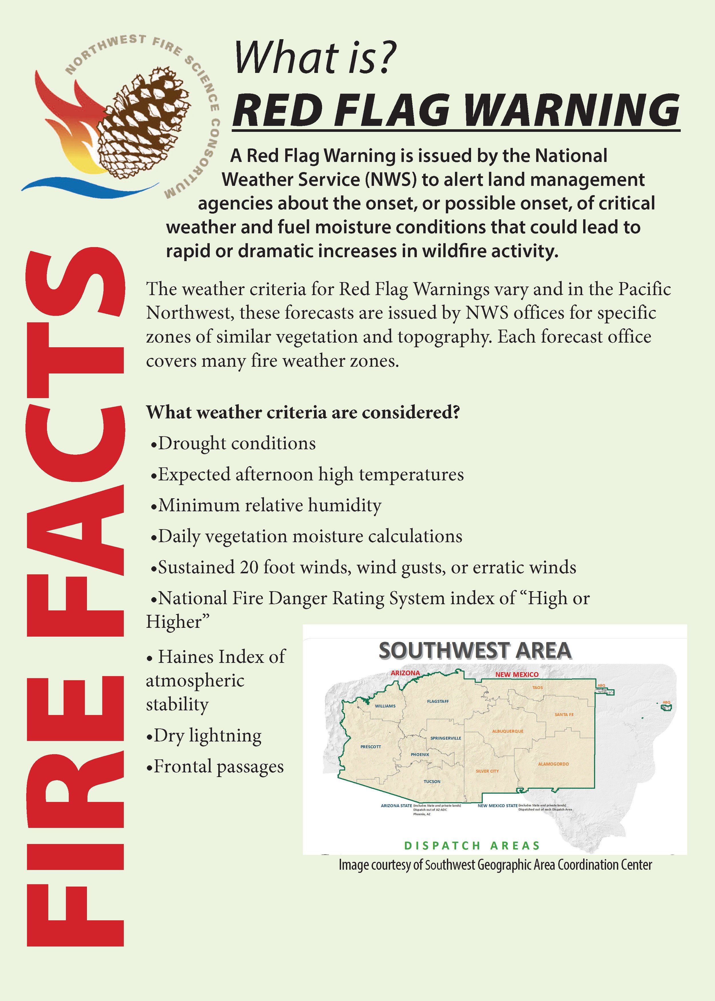
Resource and image adapted from the Northwest Fire Science Consortium.

The four critical weather elements that produce extreme fire behavior are low relative humidity (RH), strong surface wind, unstable air (an incoming or outgoing storm system that creates a significant temperature differential between the land surface and lower atmosphere), and drought (NWCG, Critical Fire Weather). In the Southwest, drought becomes an important precursor to critical fire weather by drying out live vegetation as well as logs, sticks, needles, and grass on the ground, therefore increasing fuel availability. These weather elements, combined to create an unusually dry airmass for the region and season, produce extreme fire behavior when a fire does start.

Drought serves to pre-dry flammable material (fuel) and weakens live vegetation by decreasing the amount of water available, making it more susceptible to pests, disease, and mortality. Warm temperatures and low humidity (moisture in the air) further dry fuels, priming them to burn just like cured firewood. Unstable air creates erratic and often strong winds at ground-level, providing ample oxygen to fire starts and quickly fanning the flames to push the fire through those cured fuels. In this way, fires burn hotter, climb up into the forest canopy, and move faster. As the fire gets bigger, it will begin to pre-heat the vegetation and fuel ahead of the flaming front, enabling it to burn even faster and eventually create its own weather.

With summer and the transition to our monsoonal precipitation pattern rapidly approaching, we should note that light monsoons can produce gusty wind, low RH, and lightning without much precipitation.

Learn more: NWS Explainer

The geographic scope of Red Flag Warnings

How Red Flag Warnings are forecast

There are several contributing factors for when it comes to issuing a Red Flag Warning, but primary guiding criteria include relative humidity of 15% or less combined with sustained surface winds, or frequent gusts, of 25 mph or greater. Both conditions must occur simultaneously for at least 3 hours in a 12 hour period, according to the National Weather Service. 

Meteorologists are moving toward being able to consider how all forecasted weather elements combine to create hazardous conditions, even if they don’t fit the criteria individually. Maybe the RH isn't quite as low as 15%, but the temperature is extremely high and the winds are high, which could lead to dangerous fire weather conditions.

PowerPoint slide showing a map of the US with wind and humidity forecasts combining to identify areas of elevated, critical, or extremely critical fire weather.

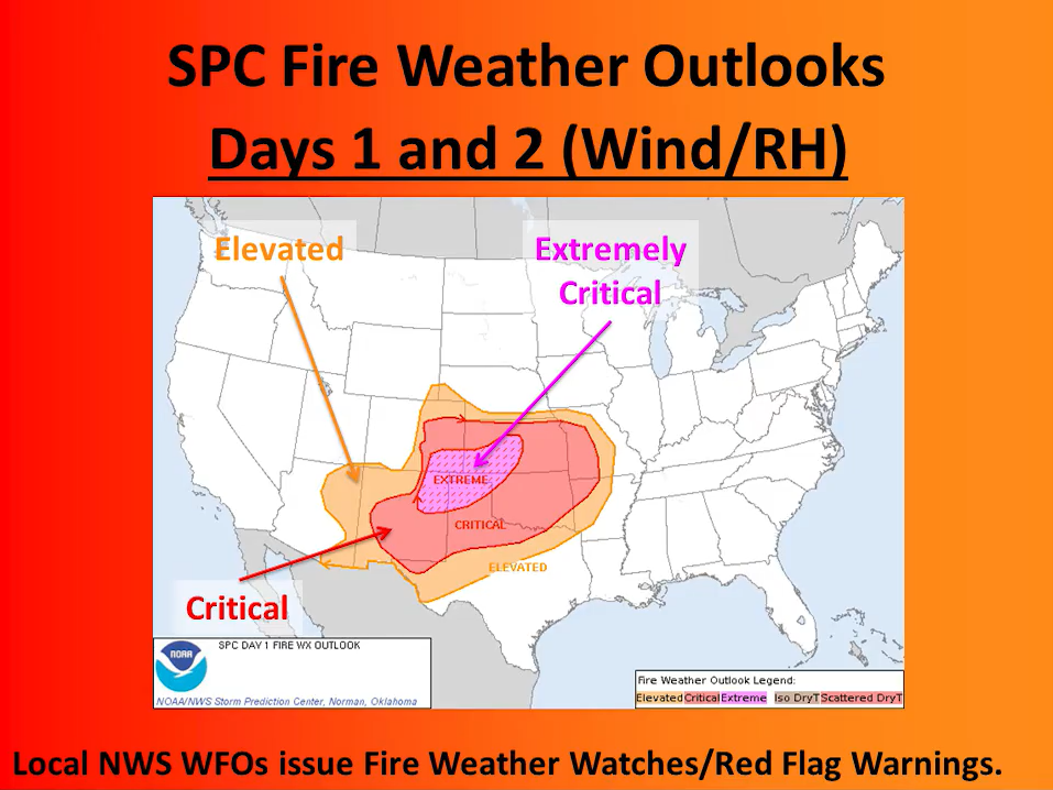
Local forecasts inform the national NWS Fire Weather Outlook forecast by feeding into fire weather composite maps and short-wave ensemble forecasts. For local Red Flag Warning alerts, however, meteorologists look at forecasted temperature, incoming and outgoing storm systems (high- and low-pressure systems) with their potential for wind, the likelihood of wet or dry lightning, the dryness of fuels based on recent precipitation and season, and how local terrain will interact with wind and potential ignitions (YouTube: Forecasting Fire Weather in the US).

While Fire Weather Watches may be issued with meteorologists forecasting up to 8 days in advance, Red Flag Warnings are only issued when the severe fire weather conditions meeting the criteria for these Warnings are expected to begin in the next 12-24 hours.

Local alerts

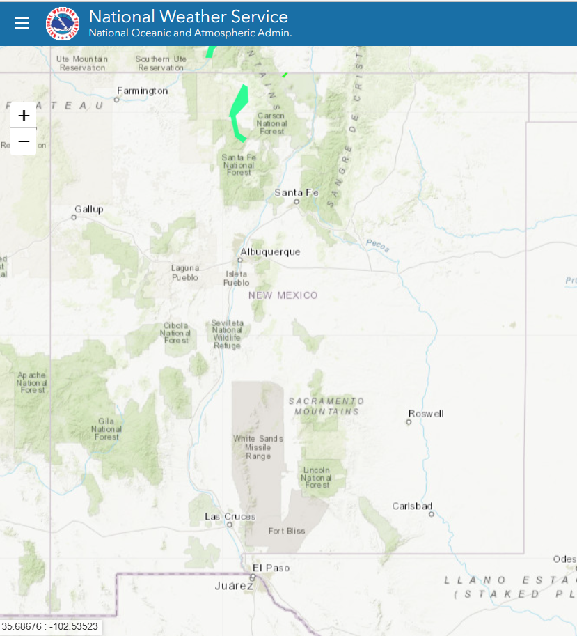
Click to visit the Red Flag map from the National Weather Service

White text on a black screen providing additional information about a Red Flag Warning, including the severity of the threat, the timeframe of the alert, and a description of the threat.

As described in the previous section, fire weather forecasts are specific to a certain geographic area based on storm systems, temperature, terrain, and winds. Accordingly, Red Flag Warnings are site-specific, which means that one part of the state (e.g. the eastern plains near Las Vegas) may be under a Red Flag Warning while another part (e.g. Santa Fe on the other side of the mountains) is not.

The National Weather Service provides information on the scope of Red Flag Warnings. This information may be found in the alert itself (a text box showing what cities or areas are covered by the alert), or can be found by visiting the NWS weather hazards map (far left).


What you should do

How to respond to a Red Flag Warning

Spread the word!

Educate your friends, family, and neighbors on what Red Flag Warnings are, what they mean, and how to respond when they see the warning pop up. Additionally, remind those in your household of the following practical steps to take on Red Flag days.

Research the scope of the Warning and restrictions for your area

Visit the NWS interactive weather hazard map to determine the area covered by a particular Red Flag Warning. Once you know if your current (or planned) location is under a fire weather watch or Red Flag Warning, visit the local city or county webpage to find out if that area is also under current fire restrictions or burn bans.

Map of new mexico overlaid with county boundaries and red shading of various intensities showing local current fire restrictions

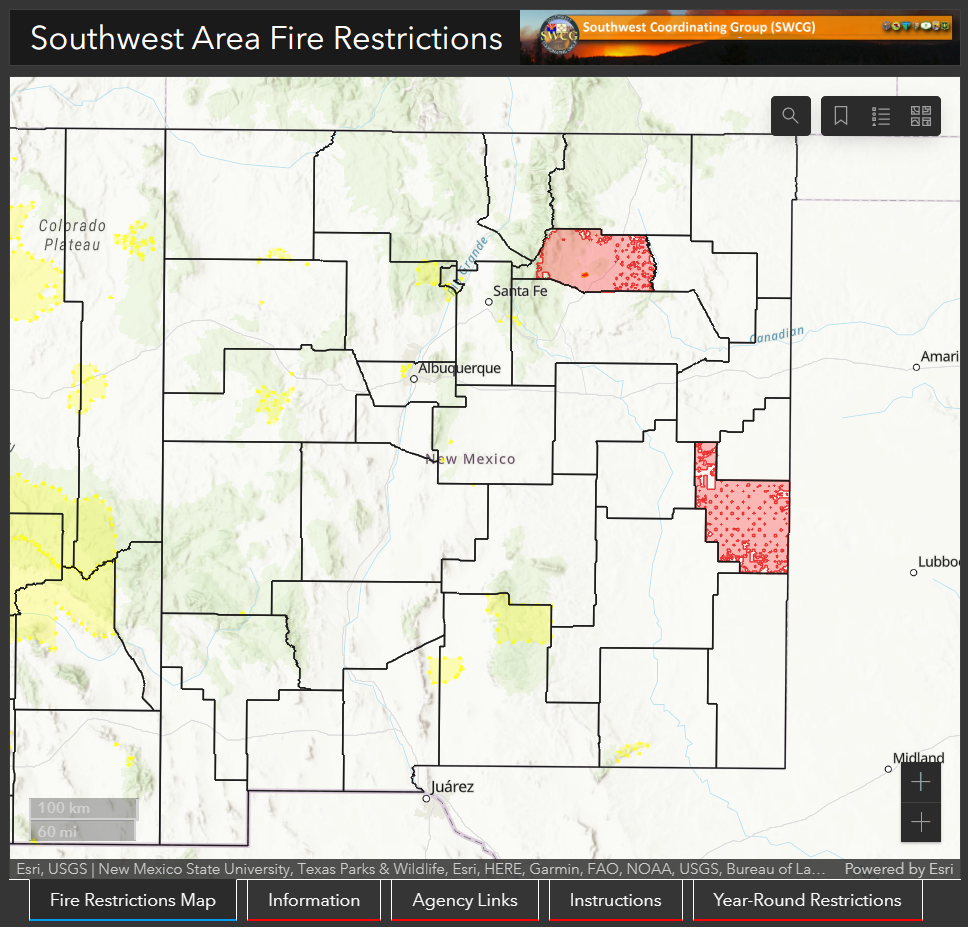
Begin your fire restrictions research by clicking on the image to visit the Southwest Area Fire Restriction map, hosted by the National Interagency Fire Center and the SW Coordinating Group.

Local municipalities may issue burn bans for a single day or several days at a time. These usually indicate that residents should refrain from certain activities, such as burning debris piles and cooking over open fires. State and National Parks as well as National Forests, however, may enter into fire restrictions for long periods of time. These restrictions indicate a prolonged (seasonal) period of dangerous fire weather and visitors to these public lands should refrain from building fires outside of designated fire rings or pits, using chainsaws, and more, based on the level of restriction. During the warm months, it is always a good idea to visit the webpage of your destination park or forest prior to leaving so that you are aware of any restrictions in place.

Adjust your behavior accordingly

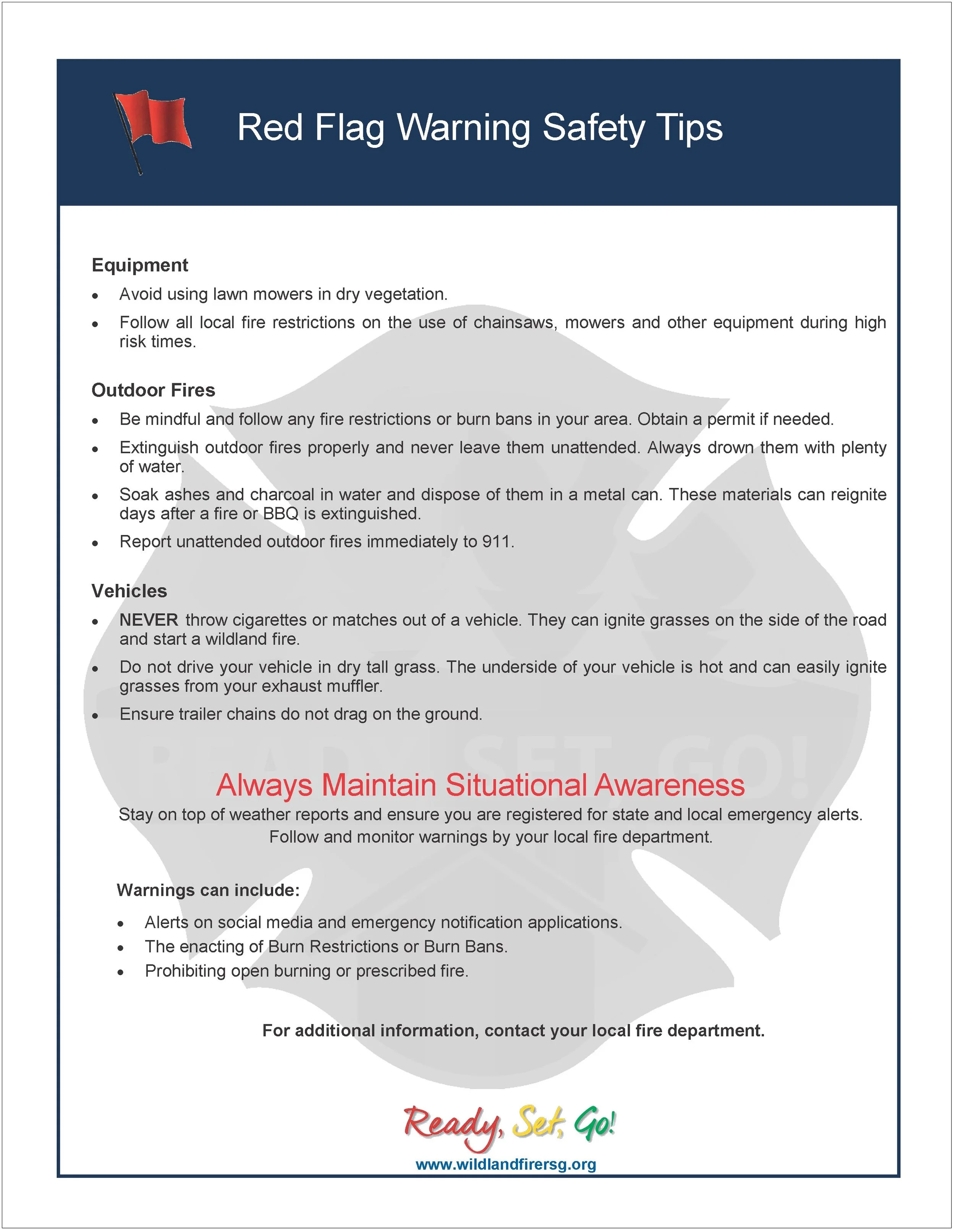
  • DO NOT burn debris piles.

  • If you are allowed to burn in burn barrels in your area, cover them with a weighted metal cover, with holes no larger than 3/4 of an inch.

  • DO NOT throw cigarettes or matches on the ground or out of a moving vehicle. They may ignite dry grass or debris and start a wildfire.

  • If outdoor fires are allowed, make sure to extinguish them properly. Drown fires with plenty of water and stir with a shovel to make sure everything is cold to the touch with bare skin. Dunk charcoal in water until cold. Do not throw live charcoal on the ground and leave it.

    • Never leave a fire unattended. Sparks or embers can blow into leaves or grass, ignite a fire, and quickly spread.

  • Avoid parking a recently driven vehicle on dry grass or other areas with vegetative cover.

  • Ensure that no chains or hanging metal are dragging from your vehicle or tow-behind trailer which could cause a spark.

Prepare your home

Person checking a window screen from the outside to ensure the window is closed

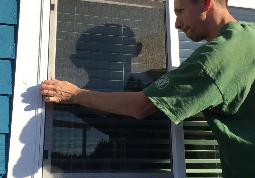
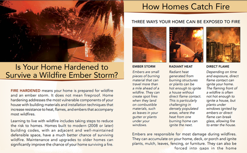
Before leaving home for the day, make sure that all house and car windows are closed and bring flammable materials like outdoor cushions inside the home or garage.

Photo courtesy of Sonoma County Emergency Management Department.

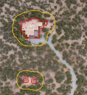
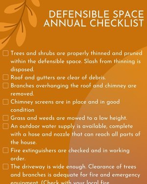
Create defensible space (including removing dead vegetation from around the house and clearing debris from gutters, around doors, and under porches).

Plan for possible ignitions or evacuations

  • keep your phone charged

  • make sure you know where your loved ones — especially people with disabilities or mobility issues — are during the day

  • make a plan for what to do with any pets or livestock in case of an evacuation.

Additional resources

WILDFIRE WEDNESDAYS #110: COMMUNITY WILDFIRE PREPAREDNESS DAY 2023

Wildfire Wednesdays #110: Community Wildfire Preparedness Day 2023

Happy Wednesday, Fireshed community!

This Saturday, May 6th is national Community Wildfire Preparedness Day! This is a great opportunity to reach out to your friends, family, and neighbors and engage them in conversation and action to reduce your wildfire risk. Wildfire does not stop at the fence lines and the more that we can work together with those in our communities, the more effective our wildfire risk reduction efforts will be.

This Wildfire Wednesdays includes:

  • Information about Community Wildfire Preparedness Day

  • Ideas for action for this Wildfire Preparedness Day

  • An article about the Santa Fe Mountains Landscape Resiliency Project

  • A webinar with New Mexico State Forestry Division with information about upcoming funding opportunities

Best,

Gabe

Wildfire Community Preparedness Day

Wildfire Community Preparedness Day is a national campaign that encourages people and organizations everywhere to come together on a single day to take action to raise awareness and reduce wildfire risks.

It is held in the United States and Canada on the first Saturday in May. Prep Day is focused on what residents can do on and around their home to help protect against the threat of wildfires.

Plan your Project

Wildfire Community Preparedness Day encourages people to come together to take action to reduce wildfire risks. This year, Preparedness Day is focused on what residents can do on and around their home to help protect against the threat of wildfires. The Prep Day toolkit provides a list of project ideas, safety tips, and more, to help guide you towards event day.

Click here to download the toolkit.

Ideas for Action on Wildfire Prep Day

Click here to download the action guide!

This “menu” describes different projects that FAC members have organized in tandem with the National Fire Protection Association’s National Community Wildfire Preparedness Day. In addition to project overviews, the menu provides information about costs, equipment, planning needs, etc.

For more information, click here.


Resiliency project — done right — can benefit the forest

“Many readers have opposed the Santa Fe Mountains Landscape Resiliency Project, stemming from their love of our mountain landscape and their fear our forests will be irreparably harmed by the burn prescriptions in the U.S. Forest Service plans.”

To read the full article, click here.

Upcoming Webinars

Webinar: State of the State - 2023 Forestry Division updates, Wildfire Defense Grants, and fire preparedness resources

Thursday, May 11, 2023 3:00 PM 4:00 PM

Click here to register!

On Thursday, May 11th, Jacob Pederson with NM Energy, Minerals, and Natural Resources Department – Forestry Division will join FAC NM to discuss the role of Forestry Division before, during, and after fire.

To hear about the Prescribed Fire Act and certified burner training, Community Wildfire Defense Grant (CWDG) summer proposal preparation, and how the Forestry Division is innovating, leading, and staying involved with fire preparedness and recovery efforts, please register below or join us on Facebook Live. This webinar is presented in concert with EMNRD.

Job opportunity closing soon: Fire Adapted Communities Manager

Fire Adapted Communities Manager

Apply by April 30th!

The Forest Stewards Guild, a member of the Greater Santa Fe Fireshed Coalition and FACNM, is hiring a full-time project manager to facilitate the implementation of a $1.3 million Community Wildfire Defense Grant award advancing Fire Adapted Communities in New Mexico. This Santa Fe-based position will support projects described in the 2020 Santa Fe County Community Wildfire Protection Plan.

Ideal candidate:

Should have strong project management skills, including experience coordinating collaborative partnerships, budget and match tracking, strong organizational and facilitated leadership skills, a demonstrated ability to communicate effectively, knowledge and experience in forestry or wildfire mitigation, and the ability to think strategically. As project needs are identified, the Project Manager will collaboratively develop solutions to move project outcomes forward.

Duties may include:

  • Lead collaborative efforts to build and sustain the strength of the Greater Santa Fe Fireshed Coalition;

  • Support the Fireshed’s Neighborhood Ambassador program by recruiting ambassadors and interfacing with the Coalition;

  • Expand wildfire mitigation efforts in the Wildland Urban Interface by working with and supporting landowners and contractors;

    • Conduct home hazard assessments, high priority fuel mitigation treatments, and public outreach;

  • Support the Guild’s program of work, as needed.

Next steps:

Interested applicants should visit the job positing on Smart Recruiters and click “I’m Interested” to submit a one-page cover letter, resume, one-page writing sample, three professional references, and earliest available start date.

Read the full position description, review the compensation and benefits package, and apply online by midnight on Sunday, 4/30/23!

APPY NOW

Wildfire Wednesdays #109b: Preparing for Fire Part II

Happy Wednesday, Greater Santa Fe Fireshed Coalition readers!

After a busy week, we’re back with more information on getting ready for wildfires in Part II of our Preparing for Spring Ignitions Wildfire Wednesdays blog series. Part I can be found here. As the days get longer, warmer, and windier, we will continue discussing how to prepare and stay informed for ignitions, smoke, and flames in 2023.

Today’s Wildfire Wednesday features:

  • Staying informed during a wildfire

  • Community Wildfire Defense Grant (CWDG) awards

  • Job announcement: Fire Adapted Communities Manager

  • CWPP Assistance Program application information

  • Upcoming events and opportunities for engagement

Take care,

Rachel


During a Fire - Staying Informed

Be aware of active incidents

Notification systems can alert residents of risks and evacuation needs during emergencies. Emergency management agencies, counties, and even individual cities have developed local emergency alert systems which send notifications to cell phones and computers in the area based on a device’s location data.

CodeRED alert system allows state and local agencies to deliver geo-targeted, time-sensitive information to individuals who have registered to receive alerts. Notifications can be sent via email, SMS, voice, mobile app push notifications, Integrated Public Alert & Warning System (IPAWS), and more depending on the severity of the situation.

CODERED APP
REGISTER FOR ALERTS

Nixle is another alert system preferred by some local agencies to provide real-time text notifications of natural disasters, severe weather, missing persons, and more. You can opt in by texting your zip code to 888777.

NIXLE WEBSITE

Emergency management alert system used by each county in NM, courtesy of NMSU. Click to view PDF.

Ready.gov provides information on different types of emergency alerts, what purpose they serve, and how to sign up. Visit the website to learn more.

Local registration: certain counties around New Mexico have developed emergency notification systems which allow incident managers to alert residents to an emergency in their area. Below are links to sign up for some of the most heavily populated parts in the state, or you can search online by county to find information for your area.

Air quality and other important alerts

For all residents, especially those who are sensitive to or at-risk for respiratory hazards, summer wildfire smoke can present a serious nuisance and a health hazard. The first step toward protecting yourself and your family is to be in the know when the air in unhealthy to breathe.

AirNow is a collaborative effort of governmental and local air quality agencies to provide educational and real-time resources on air quality, wildfires, and more. The site provides interactive Air Quality Index (AQI) maps, Fire and Smoke maps, and information on using AirNow during wildfires.

AIRNOW APP
AQI MAP
WILDFIRE INFORMATION

IQAir AirVisual website and app provide real-time air quality information based on sensors close to your location. The app also provides air quality forecasts and health recommendations to reduce your risk during times of high-exposure to pollutants. This software may be linked to personal IQAir air quality monitors for best accuracy.

IQAIR WEBSITE
ANDROID APP
IOS APP

PurpleAir is another source of real-time local air quality information provided on a publicly available map. It pulls data from a network of air quality monitoring sensors to provide alerts of the density of PM2.5 pollutants in a given area.

PURPLEAIR WEBSITE

Best practices for healthy lungs

Wildfire smoke effects on sensitive population:

  • Lung or heart disease: individuals with heart disease, chest pains, lung disease, and asthma are at an increased risk from wildfire smoke. 

  • The elderly: elderly individuals are also highly susceptible to wildfire smoke due to an increased risk of heat and lung diseases.

  • Children and infants: children and infants have airways that are still developing and breathe more air per pound of body weight than adults. Children are more at risk since a majority of their time is spent engaging in activities and play. 

Take steps to reduce risks to your health:

  • Check local Air Quality Index (AQI).

  • View and download Clean Indoor Air info: informational sheets to guide you to clean air indoors during wildfire smoke events.

  • Limit outdoor exposure: Staying indoors as much as possible during wildfires can help reduce your risk of health complications from smoke. Limiting or abstaining from outdoor activity is advised when smoke from wildfires is present.

Diagram of the multiple layers which make up a HEPA filtration system and the particulates that each layer is designed to capture.

  • Keep indoor air as clean as possible: If advised to stay indoors from high levels of wildfire smoke, keep all windows and doors closed. Use an air conditioner or HEPA filter if you have one but keep the fresh-air intake closed and the filter clean to prevent outdoor smoke from getting inside. If you do not have an air conditioner or filter, seek shelter in a designated evacuation center or away from wildfire smoke activity. Learn about FACNM’s HEPA loan program.

  • Follow advice from your healthcare provider: If you are sensitive to smoke from wildfires, or experience trouble breathing from smoke, contact your healthcare provider immediately.  

Ash clean-up:

  • Do not use leaf blowers.

  • Do not allow children to play in the ash.

  • Wait until conditions improve to clean up ash.

  • Use a damp cloth and spray areas lightly with water, direct the ash-filled water to the ground areas, and away from the runoff system.

  • Take your vehicle to the car wash and wash toys that have been outside in the ash.

  • Due to its corrosive nature, avoid skin contact with the ash by wearing gloves and long-sleeved shirts.

  • If you have existing heart or lung conditions, avoid doing ash clean-up yourself or anything else that stirs the particles back up into the air.


Expanding Fire Adapted Communities

CWDG Grant awards and employment opportunity

A 1.3 million dollar grant awarded to the Forest Stewards Guild (the Guild) will go toward reducing the wildfire hazard for Santa Fe, Pueblo of Tesuque, Pueblo of Nambe, and surrounding communities. Under the eligibility terms of the Community Wildfire Defense Grant (CWDG), this funding will support projects described in the 2020 Santa Fe County Community Wildfire Protection Plan.

Over the next five years, the Guild and partners in the Greater Santa Fe Fireshed Coalition will engage in Community Wildfire Mitigation by conducting over 500 home hazard assessments and completing more then 125 acres of high priority fuel mitigation treatments. The Coalition will work to elevate public outreach and education while simultaneously increasing the number of Fireshed Ambassadors. Expansion of the Fireshed Ambassador program, which is based on the knowledge that neighbors are influenced by neighbors and that volunteer community leaders can multiply the efforts of subject matter experts, will foster Fire Adapted Communities. This work will be facilitated by a new Fire Adapted Communities Manager based in Santa Fe.

APPLY NOW: FIRE ADAPTED COMMUNITIES MANAGER

Read more about the grant award, the FAC Manager position, and how the Guild plans to decrease fire risk in the greater Santa Fe area on the Greater Santa Fe Fireshed Coalition webpage.

Read about all five CWDG proposals, totaling $11,482,174, which have been funded across the state on the US Forest Service grants webpage under “New Mexico”.


CWPP Assistance Program

Fire departments and partnering agencies encouraged to apply

Managed by the International Association of Fire Chiefs (IAFC), this Community Wildfire Protection Plan Assistance Program aims to provide resources for updating or developing CWPPs and engagement efforts to six departments/agencies in communities at high-risk of wildfire. Each department will be responsible for reaching out to local interestholders, evaluating the plan per IAFC subject matter expert assistance and guidance, and ensuring community engagement.

There will be additional funding of up to $6,000 for a community engagement day and a required in-person tabletop evaluation of the CWPP at the end of development. This project will require a significant time commitment and dedication from department personnel, participation with interested community members, and a dedicated CWPP writer.

Timing  
April 30, 2023 – Applications due.  
Mid-May 2023 – Selected departments are notified. 
June-July 2023 – In-person kick-off meetings to be completed. 
July 31, 2024 – CWPP Evaluation Tabletop must be completed. 
August 31, 2024 – Closeout reports are due to IAFC. A template will be provided.

APPLY FOR CWPP ASSISTANCE

Contact Derek Bullington at Derek.Bullington@iafc.org or (703) 537-4832 with any questions.


Upcoming events

Demonstrations

April 25 and 27, 10am - 4pm: Biomass Removal Demonstration Event, public open house, Flagstaff, AZ.
Dr. Han-Sup Han of ERI, in collaboration with Coconino County, UofA Cooperative Extension, and RMRS, will lead a one-week trial beginning April 24 testing the performance of an Air Curtain Burner for biomass disposal and a CharBoss for biochar production. Takes place at the Coconino County Public Works Facility at 600 E Commerce Avenue, Flagstaff, AZ 86004.


Webinars

April 21 at 12pm: Santa Fe National Forest Prescribed Burning Webinar, live on Facebook.
Join the Santa Fe National Forest leadership team as they discuss the use of prescribed fire on the national forest. Specific topics will include practices and procedural changes following the national 90-day pause on prescribed burning and implementation of the seven tactical changes from an operational basis. Held in partnership with FAC NM.

May 11 at 3pm: 2023 Forestry Division updates and fire preparedness resources, Zoom and Facebook Live with New Mexico Forestry Division.
Jacob Pederson with NM Energy, Minerals, and Natural Resources Department – Forestry Division joins FAC NM to discuss the role of Forestry Division before, during, and after fire. Specific topics may include the Prescribed Fire Act and certified burner training, Community Wildfire Defense Grant (CWDG) summer proposal preparation, and how the Forestry Division is innovating, leading, and staying involved with fire preparedness and recovery efforts.

REGISTER NOW

Smoke from the 2019 Museum Fire near Flagstaff, AZ. Photo courtesy of Melanie Colavito, NAU.

May 11 at 12pm: Public Experiences and Perceptions with Wildfire and Flooding, Zoom webinar with the Southwest Fire Science Consortium.
Gain insights into public perceptions on wildfire and post-fire flooding with suggestions on how to improve information exchange! The research presented provides insights into public experiences with and perceptions of wildfires, post-wildfire flooding, and forest management more broadly over time, and offers suggestions for improving the exchange of information between and among agencies and the public to facilitate mutual understanding and enhance adaptive capacity for future wildfires and flood events.

REGISTER NOW

Wildfire Wednesdays #109: Preparing for Spring Ignitions

April 6, 2023 marked the one year anniversary of the wildfire declaration for what would become New Mexico’s largest in recorded history: the Hermit’s Peak-Calf Canyon Complex. Many communities were, and are still, devastated by the immediate and post-fire effects, flooding, and massive impact to their way of life. Learn more about the fire, what is being done to recover, and reflections from a state representative one year later..

Happy Wednesday, Fireshed readers!

The strong spring winds and warming temperatures that have blown into New Mexico over the past few weeks let us know that wildfire season is just around the corner. In preparation, we will be presenting new information, as well as revisiting some Wildfire Wednesdays of the past, to discuss how to get ready and stay informed for ignitions, smoke, and flames in 2023.

Today’s Wildfire Wednesday features:

  • Preparing your home for wildfire

  • Safeguarding important records

  • Upcoming webinars and learning opportunities

Be well and enjoy the blooms,

Rachel

Preparing Your Home for Wildfire

The Home Ignition Zone includes the immediate (0-5’), intermediate (5-30’), and extended (30-100’) hazard zones extending out from your home. Creating defensible space and reducing structural ignitability may mean working with your neighbors to clear debris and thin around your home.

Reducing Structural Ignitability
The Home Ignition Zone encompasses the concepts of home hardening and defensible space. Home hardening involves consideration for the materials used to build a structure, while defensible space involves clearing an area between a structure and the vegetation around it. By working on these two components, risk of home and structure loss to wildfire can be meaningful reduced.


Defensible space

Checklist from NMSU and Firewise® on defensible space actions that can be taken annually

Defensible space is the buffer you create between a building (such as your home) and the flammable grass, trees, shrubs, or any wildland area that surrounds it. This space is needed to slow or stop the spread of wildfire and it helps protect your home from catching fire - either from embers, direct flame contact, or radiant heat. Proper defensible space also provides firefighters a safe area to work in and potentially to defend your home.

Simple defensible space tasks to get you started on protecting your home include:

  • clearing the 0-5’ home ignition zone immediately around the structure of all flammable materials including plants, mulch, grass, leaves, and debris,

  • removing flammable materials from under your deck, and

  • trimming trees.

Read more about home hardening and creation and maintenance of defensible space for homeowners, renters, and other residents on the FACNM Wildfire Resident Resources page, through NM Forestry Division, and in Wednesday blogs #101 and #91.

Home hardening

Home hardening addresses the most vulnerable components of your house with building materials and installation techniques that increase resistance to heat, flames, and embers that accompany most wildfires. Laboratory research and evidence from post-fire assessments have demonstrated that local ignitability of the home itself and the nearby landscaping are major factors determining home survivability in a wildfire. In fact, most homes ignite due to the ember storms that accompany a large wildfire, rather than the wildfire itself, and this home hazard assessment can help you evaluate whether your place of residence would benefit from home hardening.

Simple home hardening measures to get started include:

  • installation of fine mesh screens over existing home vents,

  • moving outbuilding further away from your home, and

  • ensuring that the bottom 6 inches of your home’s siding is covered with a fire resistant material.

Review the guidelines for home hardening and learn more about why homes burn, and what you can do to retrofit yours to be more resilient against wildfire, in this 2017 FAC Net article.

Meaningful projects you can complete in as little as 10 minutes

Even small actions can have a big impact on fire outcomes for your home, family and community. Whether you have 10 minutes or 10 hours to dedicate to wildfire preparedness, use that time increase your safety, strengthen community resilience and improve fire outcomes. Not sure where to start? Review the list of quick fire preparedness project ideas from the national Fire Adapted Communities learning network.

Safeguarding Important Records

Record keeping for fire safety

Keeping important documents with you when evacuating, or storing them digitally in cloud based storage can help support you in the wildfire recovery process.

Evacuating your home during a wildfire is chaotic, stressful, and harried - and in the rush to get to safety it can be easy to forget to pack your important documents and records that serve as proof of your own identity as well as the legality of your belongings. Below are 10 items that you should be sure to keep safe, if applicable, and how to store them ahead of time.

  1. Insurance Info
    If you are a homeowner and your home goes through a fire, one of the very first things you’ll have to deal with is insurance. CBS recommends safe storage of “current insurance policies and agent contact information,” adding: “you’ll need this information right away if your house suffers damage in a fire.”

  2. Property Deed and Car Title
    These prove you own what you own! The deed to your property and title to your care are necessary if you’re selling or refinancing your house or property or transferring the title for estate-planning purposes.

  3. Medical Documents
    Documentation of your medical insurance - forms and copies of your insurance card - as well as “a list of your (and your family’s) doctors, prescription medications, and contact information for all pharmacies you use,” are important documents to keep safe for continuity of medical care, according to Legalzoom. “You may need these to get new supplies of medications you use on a regular basis.”

  4. Birth Certificates
    A birth certificate is needed to obtain a passport, get a driver’s license or a marriage license, apply for government and private benefits (such as insurance and retirement benefits), enroll in schools or the military, and more. If you’re a parent, you also need your child’s birth certificate as proof of age to sign them up for elementary school or Little League. It’s not too difficult or expensive to get a copy of your birth certificate, so you can keep multiples in secure storage spaces such as safe deposit boxes and with family.

  5. Passport
    A passport serves as proof of citizenship, will stand in for all ID purposes if your primary identification is stolen or lost, allow you to travel to other countries and back home, and come in handy whenever something requires two or more forms of photo ID.

  6. Social Security Card
    Your social security card is needed to apply for a job or a driver’s license, register for college classes, possibly to apply for insurance or Medicaid, but your SSN (social security number) is needed in far more everyday situations.

  7. Wills
    Most lawyers weighing in from the American Bar Association recommend keeping original wills in a law office’s safe or personal safety deposit box. Copies of the will may be kept in fireproof safes of the client as well as the executor, meaning that you should ensure that your will is kept safe in three different locations.

  8. Financial Documents
    According to Legalzoom, you’ll want such things as “important papers related to investment accounts, retirement plans, bank accounts, and associated contact information” protected, whether or not your home is ever destroyed.

  9. Other Legal Documents
    CBS lists other types of documents that you’ll want to keep well-protected: “powers of attorney, living wills, and health care proxies - both for yourself and for anyone else for whom you are designated attorney-in-fact or health care surrogate.”

  10. Photos
    In addition to having your most treasured photos in your home evacuation kit, Legalzoom recommends keeping “CDs or an external hard drive containing digital copies of all family photos” - or other treasured photos - in your safe. Cloud storage, or off-site (online) storage that's maintained by a third party and an alternative to storing data on-premises, is a good alternative to keeping photos in a safe and is usually free to users (with some amount limits).

Document storage

From FAC Net’s Ideas for Wildfire Preparedness Day, one major preparatory action should be protecting your assets. These include:

Google Drive is one example of a cloud storage platform that you can use to backup your important documents digitally. Be sure to look around to find a platform that meets your specific needs.

  • Backing up your important documents and photos to cloud storage to reduce the amount of physical material you would want to take if you need to evacuate. 

  • Conducting an insurance check up to ensure your coverage is up to date and sufficient.

  • Creating a video walk through of your home or an inventory list of belongings and upload it to cloud storage (e.g. Google Drive) instead just on your computer’s hard drive. 

  • Securing renter’s insurance if you do not already have coverage and need it. 

Several of the points on this list point to the need to backup important files to cloud storage. Anything that you can’t afford to lose should be digitized and stored in a disaster-resistant location. We already talked about what cloud storage is in the section above, so now we’ll dive into how to find the right fit.

Price and security: many cloud storage options are free to users, with some amount limits. This article reviews some of the most secure cloud storage options and their costs. The amount of security needed will also vary depending on what type of digitized materials you are uploading to the cloud - family photos are important but not sensitive, while copies of social security cards, property deeds, and financial documents should have encryption and security at front of mind. Consider talking to your financial institution, legal executor, and other professionals in your life about storage options that they recommend.

Upcoming Webinars

Southwest Fire science

13 April at 12pm MDT: How wildfire policies governing management of natural ignitions have evolved over the past century - Zoom webinar with NAU’s Scott Franz.
Review of the history, policies, and challenges behind “managed wildfire”, the fire management strategy of leveraging natural ignitions for resource objectives and community benefit.

REGISTER NOW

11 May at 12pm MDT: Public Experiences with Wildfire and Flooding: A Case Study of the 2019 Museum Fire - Zoom webinar with a panel of researchers with NAU.

2 June at 12pm MDT: The Year Past and the Year to Come: 2022 Southwest Fire Season Overview and 2023 Fire Season Outlook - Zoom webinar with staff from the National Weather Service and Forest Stewards Guild.

Keep an eye on the Southwest Fire Science Consortium event page for more information and registration.

Local news

21 April at 12pm MDT: Use of prescribed fire on the Santa Fe National Forest - Facebook Live with Santa Fe National Forest staff and the Forest Stewards Guild.
A USFS panel will lead a discussion on 1) practices and procedural changes resulting from the 2022 national 90-day pause on prescribed burning, and 2) implementation of the seven tactical changes from an operational basis. The conversation will be moderated by FACNM.