Wildfire Wednesdays #73: The Ecological Role of Fire

Hello Fireshed community,

Happy Wednesday and a happy Thanksgiving to you and your family! This year we’re feeling particularly grateful for the beautiful landscapes of Northern New Mexico that we live and recreate in and the fire personnel that keep our ecosystems and communities safe. While we often share resources on how to prepare for or cope with wildfire, this week we wanted to share with you information regarding the ecological role of fire. The role of fire varies across landscapes and many ecosystems have evolved to have specific and beneficial relationships with periodic wildlife. Keep reading to learn more!

This week’s Wildfire Wednesday features information on:

  • How fire benefits ecosystems

  • Fire adapted species

  • Fire return intervals

Best,

Liz


How fire benefits ecosystems

Periodic, low-intensity fire can have many positive effects across ecosystems, keep reading to learn more or click on any of these sources to dive deeper: Benefits of Fire (Cal Fire); Fire Effects on Soil (NAU); Fire Ecology (BLM); Fire’s Natural Role (USFWS); The Ecological Benefits of Fire (National Geographic).

Photo credit: Sharon Hood

  • “Cleans” the forest floor

    When low-intensity fire travels through the understory it removes the layer of dead or decaying plants. By removing this debris, it opens up space on the forest floor where growth of new plants is encouraged and it reduces the likelihood of high-intensity wildfire.

  • Returns nutrients to soil

    Although overall some nutrients on-site are lost during a fire, fire actually increases the amount of available nutrients in an ecosystem. Soil fertility increases after low-intensity fire as the fire chemically converts nutrients in dead plants that would otherwise take much longer to decay and return to the soil.

  • Increases diversity

    When a forest is without fire it leads to over-crowding, preventing sunlight from reaching the forest floor and creating intense competition for water and available nutrients. In the aftermath of low-intensity fire, gaps in the canopy are created allowing sunlight through and there is more available nutrients and water. Low intensity fires can also eliminate invasive/noxious weed infestations, allowing an opportunity for native plants to grow and establish. Some native species actually require fire for seed germination!

  • Creates new habitat

    Fire removes thick brush, maintains open meadows, and thins out dense forests, all creating new habitat for animals and birds. Additionally, those trees that do not survive fire create new habitat for insects and cavity nesting birds and animals.

  • Kills pests and diseases

    Fire kills populations of beetles, mites and other harmful pests which reduces disease and keeps forests healthier.

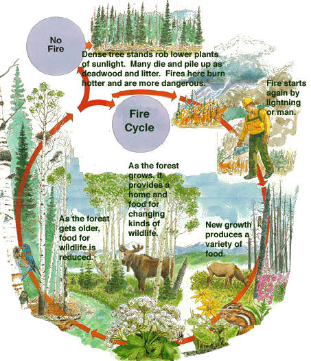
Photo credit: Harvey Mudd College


Fire adapted species

Many of our beloved plant species are fire-adapted, meaning that they have “life history traits that help them survive wildfire or to use resources created by wildfire.” There are different categories of fire-adapted plants based on the traits that allow them to survive or flourish with wildfire (from Fire Ecology by the Bureau of Land Management)

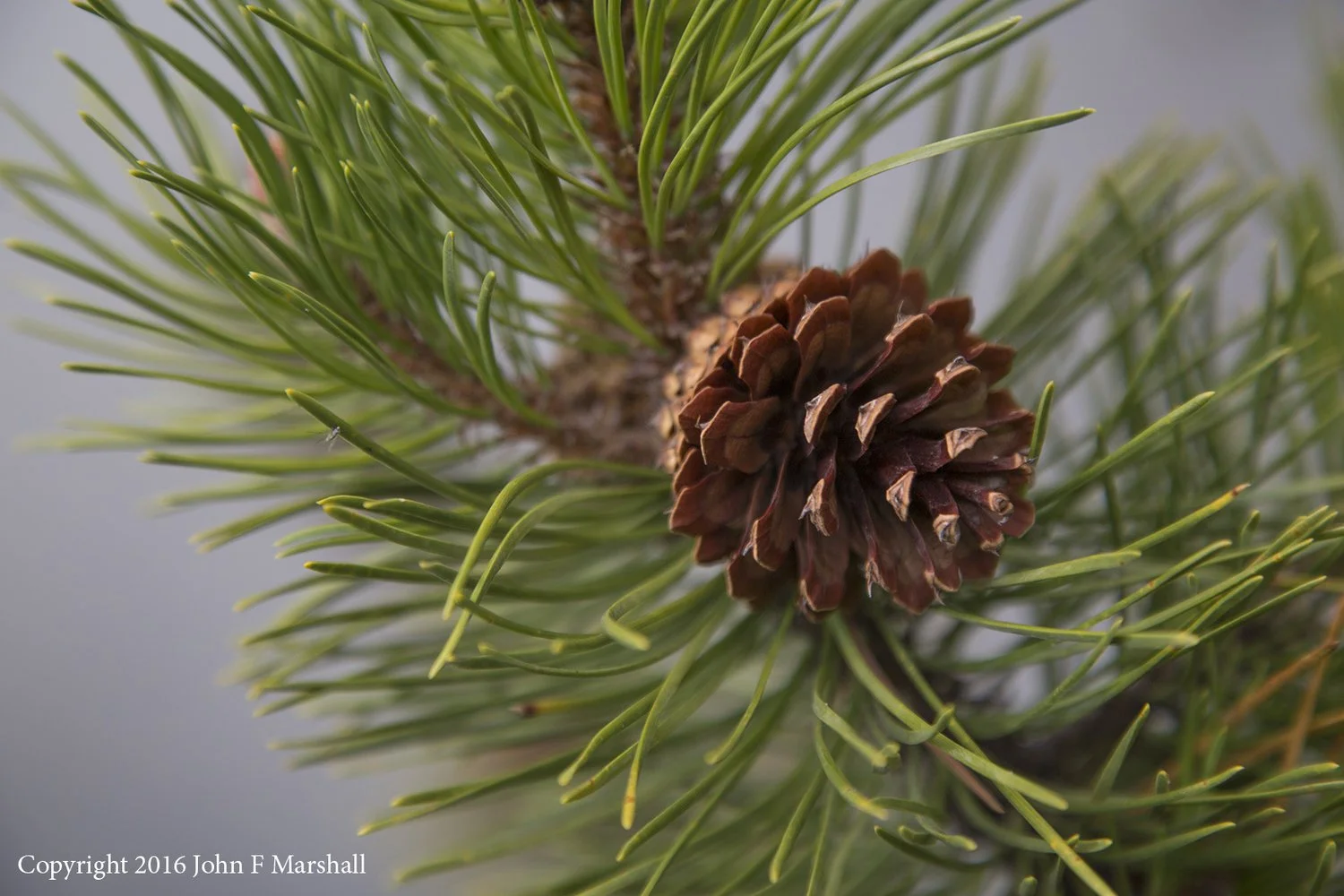
Ponderosa pines, an example of a “resister” fire-adapted species (Credit: John Marshall)

  • Resisters are the species that can survive moderate to low-intensity fires with little to no damage. Some adaptations of Resisters include: thick bark to shield them from fire; deep roots protected from fire; the shedding of their lower branches to prevent fire from climbing; and moist, short needles or leaves that are hard to burn. Some examples include: ponderosa pine, sugar pine, and Douglas-fir.

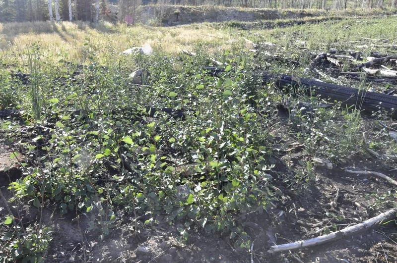
Aspen resprouting after a recent fire in Utah (Credit: Karen Mock)

  • Sprouters are the species that endure fire. Sprouters resprout from their roots, trunks, limbs, and/or crown after a burn. Many shrubs are sprouters. Some of these species also have hard shelled seeds relying on fire to crack them open. While the parent plant may be injured in a fire, the new sprouts are able to grow in nutrient rich soil and have less competition. Some examples include: oak, aspen, and madrone.

Lodgepole pines, an example of a “seeder” species, requires fire for their seeds to germinate.

  • Seeders are adapted to evade fire by shedding lots of seeds that sprout after fire. These sprouts thrive from the rich nutrients recycled into the soil. Right after a fire is a prime time for a plant to disperse its seeds and germinate because there is more space to grow and less competition for resources like sunlight, water, and nutrients. Many Seeders are dependent on fire to create the habitat needed for their seedlings to sprout and grow. Seeders are not invaders because they already inhabited the area before the fire and their population does not spread as rapidly as invaders. Some examples include: buckbrush, lodgepole pine, and manzanita.

Filling the “invader” niche, lupine will take advantage of recently burned areas (Credit: NPS)

  • Invaders take over recently burned areas. Their populations are either limited or unknown prior to fire. Invaders tend to have seeds that are highly dispersive by wind, animals, or people. Many invaders are noxious weeds that take over areas after disturbances such as a fire, flood, or development. Some examples include: star thistle, fireweed, scotch broom, and lupine.

White fir trees are “avoiders”, they tend to grow in areas where fire does not frequently occur.

  • Avoiders are least adapted to fire because they grow in areas where fire does not normally occur. They are typically found near water or in high elevations. Avoiders are a late successional species, thus they are not found in recently burned areas. Avoiders have thin bark, shallow roots, and lots of resin, which can help a fire spread. Few avoiders survive moderate to high intensity fires. Some examples include: white fir, vine maple, western red cedar, and western hemlock.

To learn more about the different traits plants develop to survive wildfire or use it to their advantage check out this Britannica article “Playing with Wildfire: 5 Amazing Adaptations of Pyrophytic Plants”


Fire Return Interval

A fire return interval is the (historical or natural) time between fires in a defined area, usually at the scale of a point, stand or relatively small landscape area. For example, fires in ponderosa pine communities burned naturally on a cycle of one fire every 5 to 25 years. This frequent fire burned the grasses, shrubs, and small trees, and maintained an open stand of larger ponderosa pine trees.

Check out this table from the Forest Service detailing fire regime characteristics for different ecosystem types in the Southwest.

Map showing the historic fire return interval in years for Arizona and New Mexico (Credit: HISTORIC FIRE RETURN INTERVALS FOR ARIZONA and NEW MEXICO: A REGIONAL PERSPECTIVE FOR SOUTHWESTERN LAND MANAGERS)

Wildfire Wednesdays #72: Wildland Urban Fire Summit (WUFS) Wrap-Up

Hello Fireshed community,

Happy Wednesday! We hope you’re having a good week and enjoying the nice weather we’ve been having. Many prescribed burns are occurring throughout Northern New Mexico at the moment, check out NM Fire Info to stay informed and read our previous blog post on prescribed fires to learn more on why these burns are important. If you’re experiencing smoke from the prescribed burns, visit our Smoke & HEPA Filter Loan Program page on the FACNM website to learn more. This week we’re reflecting and sharing resources from the recent New Mexico Wildland Urban Fire Summit: Community Resilience & Recovery (WUFS). There were a lot of great resources shared so keep reading to learn more!

This week’s Wildfire Wednesday features:

  • Talks of interest from WUFS 2021

  • The recent Wildfire Science and Values Peer Learning Session

Best,

Liz


New Mexico Wildland Urban Fire Summit: Community Resilience & Recovery

The NM Wildland Urban Fire Summit is an forum for wildfire preparedness and planning where a network of experts and peers share successes and lessons learned from “living with fire” in an effort to assist one another with fire resiliency goals and learn innovative ways to adapt communities to wildfires. At this year’s summit, presenters included those academic researchers, private business owners, hazard mitigation officers, fire instructors, forest service personnel and more. To see a full agenda from both days of the conference click here.

Talks of interest

Turning Up the Heat: Tools for Understanding, Exploring, and Reducing Wildfire Risks (Keynote), Presented by Kimiko Barrett, Ph.D.

  • Dr. Barrett, wildfire researcher and policy lead for Headwaters Economics, shared tools for long-term community resiliency that have been developed with federal, state, local and private partners. The tools discussed include the Wildfire Risk to Communities website and the Unequal Impacts of Wildfire Risk tool which uses data to show in which counties people could be disproportionately impacted from wildfires.

Beyond Grant-Writing Panic: Building the Collaborative Infrastructure to Bolster Long-Term Forest and Community Resilience from Wildfire in Taos County, Presented by J.R. Logan, Taos County WUI Coordinator.

  • This talk highlights the work being done in Taos County on improving the infrastructure to move money efficiently to high-priority forestry projects despite administrative hurdles and planning obstacles. Collaborative, community groups have been coordinating to “look at specific areas in a specific geography with specific partners and start picking away at treatments” and the county is working on aligning local priorities with those from federal agencies and building those into the CWPP.

Find the above talks and others here - Day 1, Part A (Dr. Kimiko Barrett @ 11:23 minutes; J.R. Logan @ 58:14 minutes)

Achieving Landscape Scale Piñon-Juniper Ecosystem Treatment Efficiency: Seeking a Smarter Use of WUI Dollars in PJ Stewardship. Presented by Jan-Willem Jansens, Ecotone Landscape Planning, LLC

  • Jan-Willem addresses several questions regarding the current state of piñion-juniper ecosystems, the challenges being faced, and how to effectively manage these ecosystems.

Find the above talk and more here - Day 1, Part B (Jan-Willem Jansens @ 3:37 minutes)

Firehorses: How Individuals, Communities, Fire Personnel, and Governments can Plan, Prepare, and Execute Equine Evacuations Safely. Presented by Madeleine Carey, Graduate HA, Watermelon Mountain Pony Club

  • Madeleine shares her lessons learned from helping with horse evacuations during the Las Conchas fire and her experiences with the Watermelon Mountain Pony Club. Her presentation contains many resources that may be of interest to individuals looking to prepare for equine evacuations in the case of wildfires. You can find her powerpoint presentation with links here.

Wildland Fire in the Middle School Classroom. Presented by Christine Mares, Wildland Fire Instructor, Southwest Fire Science Consortium & Mollie Parsons, Cerise Consulting.

  • This presentation shares information on the Fire Ecology Learning Lab Middle School Curriculum that is in development. The curriculum includes low/no-cost lessons for middle school classrooms with themes including biotic communities, wildland fire, and wildland fire management.

Hazard Mitigation Funding Opportunities in New Mexico. Presented by Chelsea Morganti, CFM, State Hazard Mitigation Officer, NMDHSEM

  • Chelsea introduces the different funding opportunities available in New Mexico for hazard mitigation. She explains what is a natural hazard in New Mexico, what qualifies as hazard mitigation, the pathways of grants, who is eligible to apply, match requirements, project types and more. This is a great resource for anyone interested in funding opportunities for various types of hazard mitigation, you can find her powerpoint presentation here.

Find the above talks and more here - Day 2 (Madeline Carey @ 2:03:52; Christine Mares & Mollie Parsons @ 2:14:32; Chelsea Morganti @ 3:00:41)


Wildfire Science and Values Peer Learning Session

Hosted by the National Forest Foundation in partnership with the Montana Forest Collaboration Network

During this peer learning session, speakers will:

  • Build understanding about the spectrum of complementary actions, based on available science, to protect the built environment and community values from wildfire, improve the ecological resilience of our landscapes, and improve the safety and effectiveness of wildfire management;

  • Discuss the concepts of landscape resilience, the wildland urban interface and the home ignition zone, fire management options, and the roles they play in reducing fire risk;

  • Address why fire needs to be restored to the landscape;

  • Consider the values that could be lost and how they relate to fire; and

  • Discuss how to increase the options for fire managers to implement integrated active management.

Moderated by Dr. Colin Hardy, U.S. Forest Service, Missoula Fire Sciences Lab. Speakers include:

  • Dr. Mark Finney, U.S. Forest Service Fire Lab;

  • Dr. Jack Cohen, U.S. Forest Service Fire Lab (ret.); and

  • Barbara (Bea) Day, U.S. Forest Service Portland NIMO Incident Commander.

Greater Santa Fe Watershed South Aztec Prescribed Burn Wrap-up

Smoke from the South Aztec prescribe burn travelling to the southeast of the watershed, away from the city of Santa Fe (visible on the right).

Last Wednesday, October 27, the Santa Fe National Forest conducted a prescribed burn in the Santa Fe Watershed with many partners including Tesuque Pueblo, the Forest Stewards Guild, Forest Stewards Youth Corps, Santa Fe County, and the City of Santa Fe Fire Department. The burn unit, the South Aztec, had been previously thinned to reduce fuel loads and was adjacent to several other units that have been treated in the past few years. This successful prescribed fire achieved its objectives to “reduce the risk of a high-severity crown fire, to protect the municipal water supply and restore sustainable watershed conditions… [and to] increase herbaceous ground cover to improve long-term soil stability and vegetative diversity.” 

Some of the larger fuels igniting during the South Aztec burn.

Prescribed burns, especially those that occur close to communities and high-value resources, require a tremendous amount of planning and coordination, much of which is not obvious to the public eye. When a burn plan is written a prescription is developed that sets ranges for environmental and weather conditions that must be met for the burn to take place. In preparation for a burn personnel must retrieve weather forecasts, set up smoke monitors, put up signs, notify the public via news releases, identify any archeological or historical sites, identify threatened or endangered species, involve dispatch support, prepare the control line, coordinate with partners, and more.  

Because of the watershed’s proximity to Santa Fe, the Forest Service works closely with the NM Environmental Department’s Air Quality Bureau and the New Mexico Department of Health. Coordination calls with these agencies are held before, during, and after prescribed burns and they must comply with state regulations on air quality. During the fire, hourly weather readings are taken on-site to make sure that conditions are still within the prescribed ranges. If the weather moves outside of prescribed ranges, i.e., winds grow stronger than allowed in the plan, the burning is halted or contingency plans are enacted. 

The smoke from this prescribed burn was visible from many locations across the Greater Santa Fe Fireshed. Although there are always risks associated with smoke, the effects of smoke from prescribed fire are far less than those from wildfires. The Forest Service worked closely with meteorologists from the National Weather Service to identify an optimal window where wind direction and speed would help push the bulk of the smoke up and away from town. The Fire Manager for the Aztec Springs prescribed burn said, “some communities were affected to the East and South, but the smoke levels were nothing compared to a wildland fire the same amount of acres would produce during typical June hot weather conditions.” 

Forest Stewards Guild Fire and Fuels Manager Sam Berry inspects the holding line to make sure no embers travel outside of the burn unit area.

Some members of the public expressed concern about the wind conditions on the day of the prescribed burn. Wind is one of the most important variables that fire managers take into consideration when planning a burn. The Fire Manager said, “the wind direction played a key part of the success of the burn… the wind blew the smoke into already previous treated areas and, due to the great work from the holding resources, they were able to keep the hot embers that caused spot fires small and manageable...the sustained wind kept the smoke from moving into most of our sensitive areas like schools, hospitals, highways, airport, etc.” The unit also received light precipitation before the burn which reduced the burning intensity of ground fuels, bettering the conditions for controlled burning. 

Historic wildfire suppression and a lack of previous treatments in a fire-adapted ecosystem like the Santa Fe National Forest has left the landscape within the watershed vulnerable to catastrophic wildfire. If wildfires were to occur in the watershed during the typical summer season, nearly 81% of the forest would be “subject to high-severity torching and crown fire”. Intense wildfire within the watershed would cause debris flows which could compromise the drinking water and lead to a dam breach, putting the city of Santa Fe at risk for severe flooding. Thinning and burning projects within the watershed are critical to reduce the risk of catastrophic fire and protect our municipal water source. 

View of Nichols Reservoir from the South Aztec burn unit during the prescribed burn on October 27, 2021.

The Santa Fe Watershed is a precious resource to our community and the land management treatments that are conducted within the watershed are carefully planned and conducted over decades. The diligent planning, highly trained and experienced personnel, and optimal weather conditions all aligned to make this burn successful as part of an ongoing partnership to protect our watershed. 


Wildfire Wednesdays #71: Community Wildfire Protection Plans

Happy Wednesday fireshed community!

We hope you’re enjoying fall and are excited to safely celebrate Halloween this weekend! Many prescribed burns are occurring throughout the state this month, check out NM Fire Info to stay informed and read our previous blog post on prescribed fires to learn more on why these burns are important. This week we’re sharing information on Community Wildfire Protection Plans (CWPPs) which are an important tool in protecting communities from wildfire risk and damage.

This week’s Wildfire Wednesday features information on:

  • What is a Community Wildfire Protection Plan (CWPP)?

  • New Mexico CWPPs

  • An active forest management success story: 2020 Medio Fire

  • Rural Voices for Conservation Coalition’s “Fighting Fire with Fire: Policy Options to Increase the Use of Prescribed Fire on National Forests”

  • Coyote Creek prescribed fire announcement


What is a Community Wildfire Protection Plan (CWPP)?

From the National Wildfire Coordinating Group:

“A plan developed in the collaborative framework established by the Wildland Fire Leadership Council and agreed to by state, tribal, and local government, local fire department, other stakeholders and federal land management agencies managing land in the vicinity of the planning area. A Community Wildfire Protection Plan (CWPP) identifies and prioritizes areas for hazardous fuel reduction treatments and recommends the types and methods of treatment on Federal and non-Federal land that will protect one or more at-risk communities and essential infrastructure and recommends measures to reduce structural ignitability throughout the at-risk community. A CWPP may address issues such as wildfire response, hazard mitigation, community preparedness, or structure protection - or all of the above.”

source: NM EMNRD

From the New Mexico Energy, Minerals and Natural Resources Department (EMNRD):

Community Wildfire Protection Plans have 3 primary components:

  1. Collaboration with all stakeholders throughout the CWPP process,

  2. Identification and prioritization of hazardous fuel reduction areas, and

  3. Addressing the treatment of structural ignitability within the CWPP area.

A CWPP should identify areas that need vegetative fuels removed to reduce wildfire risk and severity, suggest methods to reduce structural ignitability, and evaluate a community’s firefighting capacity. This planning process helps unite communities by identifying their risk to wildfire, their community values, and their critical infrastructure. Factored together, these concerns should produce a prioritized list of vulnerable areas to be treated, as well as the potential treatment options.
— 2020 Communities at Risk Assessment Plan (NM EMNRD)

New Mexico CWPPs

All of the counties in New Mexico either have a complete CWPP in place or are in progress of developing a complete CWPP. CWPPs in New Mexico must be approved by the Fire Planning Task Force which consists of “of local, state, federal, and tribal cooperators who assist Forestry to identify and protect areas most vulnerable to wildfires.” CWPPs are reviewed by the 1st of December each year so keep an eye out for updated CWPPs coming out soon!

Learn more & access county cwpps

An active forest management success story: 2020 Medio Fire

“The Medio Fire was a lightning-caused fire reported on August 17, 2020, on the Española Ranger District of the Santa Fe National Forest in New Mexico. During the first couple days, the Medio Fire made significant sustained runs as a high-intensity crown fire. These runs resulted in 16% high-severity burn within the total burned area. But thanks to pre-fire treatments that mitigated fire behavior, 49% of the fire burned at low severity. The 4,010-acre Medio Fire was managed with a suppression strategy, consistent with national USFS policy during the 2020 wildfire season. The 2019 Pacheco Rx (a prescribed fire) and fuel break thinning treatments played the biggest role in reducing fire intensities and preventing further fire progression to the south and east. Two large scale collaborative projects led to the treatments that mitigated fire behavior. These projects encompass all three of the priorities laid out by the National Cohesive Wildland Fire Strategy: 1) landscape resilience, 2) fire adapted communities, and 3) safe and effective fire response.”


Rural Voices for Conservation Coalition’s “Fighting Fire with Fire: Policy Options to Increase the Use of Prescribed Fire on National Forests”

“This report provides an overview of the current science and need for prescribed fire, describes barriers to the use of prescribed fire on public lands in the western U.S. managed by the Forest Service, and described policy options to overcome these barriers… prescribed fire is unique in serving to both reduce the risks associated with wildfire and to help restore ecological function in natural systems.”

click here to read

Coyote Creek Prescribed Fire Announcement!

Wildfire Wednesdays #70: Understanding Wildfire Risk

Hi Fireshed Community,

As the weather begins to change, it is a great time to take action by educating ourselves and our friends, family, and neighbors about wildfire risk. This week’s Wildfire Wednesdays newsletter shares some great opportunities for you to learn more about the relationship between New Mexico’s landscapes and wildfire.

This Week’s Wildfire Wednesdays features:

  • Join the public meeting tomorrow (10/14) about the Santa Fe Mountains Landscape Resiliency Project

  • Take a look at the Wildfire Risk to Communities tool to better understand the wildfire risk in your area.

  • Register now for the 2021 virtual Wildland Urban Fire Summit

Best,

Gabe

Public Meeting (10/14) - Santa Fe Mountains Landscape Resiliency Project

The previously announced virtual open house on the Santa Fe Mountains Landscape Resiliency Project (SFMLRP) this Thursday will livestream on Zoom, not Facebook, which will give members of the public the opportunity to speak directly with specialists who worked on the proposal.

The SFMLRP “lunch and learn” is scheduled for Oct. 14 from 12 to 1:30 p.m. The Zoom link is https://us02web.zoom.us/j/81896951009. Participants may also call into the meeting by dialing 346- 248-7799 and entering the meeting ID 818 9695 1009.

Hosted by the Santa Fe National Forest and the Greater Santa Fe Fireshed Coalition (GSFFC), the lunch and learn will begin with a brief overview of the project and then break into three virtual “rooms.” Specialists will spend 20 minutes in each breakout room to give participants an opportunity to have a conversation with them on vegetation, fire and fuels, air quality and climate, wildlife, scenery and recreation will be available.

The proposed project is designed to improve the health of a priority landscape and increase its resilience to future disturbances, including wildfire, climate change, insects and disease, by using prescribed fire and small-tree thinning on up to 38,680 acres across a 50,566-acre project area over the next 10 to 15 years. The SFMLRP was developed by the GSFFC, a multi-partner collaborative that came together to proactively address the risk of high-severity wildfire and post-fire flooding and debris flow near the city of Santa Fe.

The 30-day public comment period on the draft environmental assessment (EA) opened on Sept. 30, and comments received by Oct. 29 will be analyzed and responded to prior to a decision on the SFMLRP. Substantive comments received during this period will also establish standing to raise an administrative objection later in the decision-making process. Comments on the SFMLRP draft EA can be submitted by one of the following methods:

• CARA (Comment and Analysis Response Application) web form which is accessible from the project webpage by clicking “Comment/Object on Project”

• Email to comments-southwestern-santafe@fs.fed.us

• Regular postal mail to Española District Office, 18537 US 84/285, Suite B, Española, NM 87532

Wildfire Risk to Communities

To explore this interactive tool and better understand your wildfire risk, click here.

“Wildfire Risk to Communities is a free, easy-to-use website with interactive maps, charts, and resources to help communities understand, explore, and reduce wildfire risk. It was created by the USDA Forest Service under the direction of Congress and is designed to help community leaders, such as elected officials, community planners, and fire managers. This is the first time wildfire risk to communities has been mapped nationwide.”


Register now for the 2021 virtual Wildland Urban Fire Summit

Click the play button on the video above to hear from members of our planning committee about the 2021 summit!

Register NOW for the 2021 New Mexico Wildland Urban Fire Summit! The event takes place on October 28th and 29th from 9am-1pm MST.

This years theme is Community, Resilience & Recovery 

The Wildland Urban Fire Summit (WUFS) is one of New Mexico’s leading events for wildfire preparedness and planning. Join your peers, community leaders, fire service professionals, and federal, state, tribal, and local governments for this FREE virtual summit. Learn from communities adapting to a wildfire environment about the latest techniques, strategies, and resources for wildfire adaptation and resilience. Expand your network of peers and experts to assist you in your fire/disaster resiliency goals.

Click HERE for more information about the 2-day agenda and list of summit speakers.