Upcoming Events in the Fireshed

August 11th

The Greater Santa Fe Fireshed Coalition is hosting a learning exchange into the Hyde Park Project on Saturday, August 11th. Hikers will be joined by industry professionals who will speak about the project overview, impacts on wildlife and pollinators and prescribed fire use. This event is free and open to the public. 

Visit the event webpage to RSVP.

Hydepark_flyer.jpg

August 16th

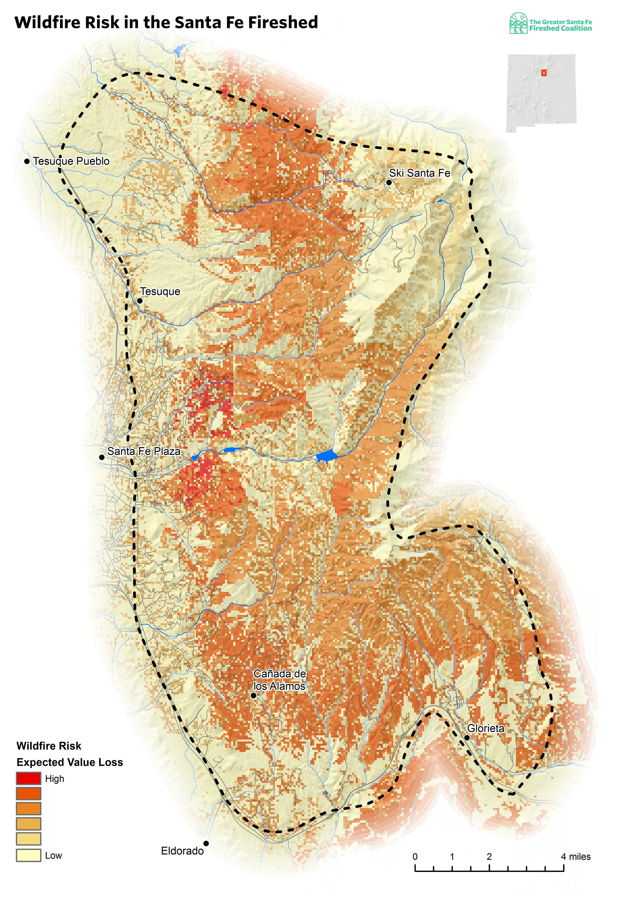
Join the Coalition on August 16th for a free presentation about fire history, the recently created Wildfire Risk Assessment and a strategy for mitigating that risk.

Hondo risk assessment_v2.jpg

Events outside of the Fireshed 

August 2 - 5

Comanche Creek Volunteer weekend. Interested in wetland restoration? If you are, then this is a great opportunity for you! Join our partner, the Quivira Coalition with restoration experts Bill Zeedyk, Jeff Adams, Mark Reineke, Margie Tatro, and Richard Smith in work to improve wetland function and keep the creeks flowing in the Valle Vidal.

Screen Shot 2018-08-03 at 2.42.25 PM.png

August 22nd

Join the Forest Stewards Guild at Fire and Hops Gastropub for a tap takeover. 10% of the evenings earnings will benefit the Forest Stewards Guild Fire and Fuels Youth Crews this Fall.

taptakeover_2018.png

Jemez Mountains invasive plant removal volunteer day

Partners of the SW Jemez Mountains Collaborative Forest Restoration Project (CFLRP) are having an invasive plant survey and volunteer day on Saturday July 14th beginning at 9am.

DSCF4001.JPG

Volunteers will meet at the Pueblo of Jemez Welcome Center, just past the Walatowa gas station and convenience store, about 1 ½ miles past the Pueblo of Jemez on State Route 4. at 9:00 am. CFLRP partners and industry professionals will conduct a brief training on plant identification and then split into groups to go out and survey the project area. Volunteers will be teamed up with folks experienced in invasive plant identification. Bring a lunch and water.

Participants should download the Wildspotter app to their smartphones if they have one to help in documenting weed locations.

For more information, contact Karl:

Karl Buermeyer - SW Jemez Mtns CFLRP Implementation Coordinator

Santa Fe National Forest, Jemez Ranger District

p: 575-829-3535 x3122 

kbuermeyer@fs.fed.us

Severe drought on the radio and a special podcast about Partnering to Manage the Wildfire Risk across large landscapes

closed.jpg

This month on “Community Matters,” a radio program broadcasted by KSFR, New Mexico’s ongoing and severe drought is the topic of discussion. Program host and Santa Fe Community Foundation CEO Bill Smith welcomes Coalition partners from the Santa Fe National Forest; the City of Santa Fe and the Forest Stewards Guild to discuss. Listen by clicking the link below.

Listen

Also for your listening pleasure is a podcast about Partnering to Manage the Wildfire Risk Across Large Landscapes: Why Forest Managers and Stakeholders Are Collaborating More than Ever from Journey Santa Fe at Collected Works Bookstore.

Podcast

Greater Santa Fe Fireshed Wildfire Risk Assessment

Risk Assessment

Written by Steve Bassett, Spatial Analyst & GIS Program Manager | TNC New Mexico Field Office


As the Greater Santa Fe Fireshed Coalition works towards building resilience to wildfire, mitigating the risk of wildfire is a core strategy. Coalition members hope to invest in wildfire risk reduction treatments in places where risk is highest. The recently completed Greater Santa Fe Fireshed Wildfire Risk Assessment will allow targeted investment in risk mitigation. Because wildfires impact all lands, and do not stop at property boundaries, this analysis evaluates risk on all lands within the Fireshed.

Wildfire risk is measured as the damage expected to be caused by future wildfires. Expected damage is highest where there is overlap between three components: expected likelihood of a fire occurring, expected intensity of a wildfire when one occurs, and susceptibility of the burned area to damage from the fire.

The recently completed risk assessment is based on the widely used Wildfire Risk Assessment Framework (Scott et al. 2013), that outlines the process for evaluating and combining the three components of wildfire risk. Every region is different so care was taken to ensure the application of the framework utilized the best available data and understanding of the local ecology and fuels.

GSFFC_RiskAssessment_Map_Template_v16_risk_negative_v02_letter.jpg


The analysis indicates nearly two-thirds of the Fireshed area is expected to lose value following anticipated wildfires.
— GSFF Wildfire Risk Assessment

To determine the likelihood and intensity of expected fires, hundreds of thousands of wildfires were simulated under a range of weather conditions. Susceptibility to fire was characterized for a range of resources and assets that were identified by Coalition members. Resources and assets that were included in the assessment capture the effects of wildfire on private investments like homes and property, public infrastructure like roads and trails, watershed function such as water provisioning and flood mitigation, recreation and cultural use such as trails and ski areas, and ecological function. Because post-fire hazards such as flooding and debris flow are of concern to the Coalition, a range of post-fire hazards were included as valued resources in terms of the mitigation value of the current landscape.

The analysis indicates nearly two-thirds of the Fireshed area is expected to lose value following anticipated wildfires. The areas with the highest wildfire risk occur where multiple resources and assets overlap, for instance where high-value watersheds and residential neighborhoods are coincident. This assessment will help the Coalition and its partners coordinate their work across landownership boundaries and to utilize risk mitigation funding more effectively.

A full summary and thorough documentation of the analytical methods are available in the Risk Assessment report.


Check the events page for upcoming events including a Risk Assessment public meeting coming near you! Time and location TBD. Stay tuned!

References

Scott, Joe H.; Thompson, Matthew P.; Calkin, David E. 2013. A wildfire risk assessment framework for land and resource management. Gen. Tech. Rep. RMRS-GTR-315. U.S. Department of Agriculture, Forest Service, Rocky Mountain Research Station. 83 p.

National Wildfire Preparedness Day - May 5th Event in Santa Fe

Join the City of Santa Fe Fire Department on Saturday, May 5th from 10:00 am to 2:00 pm at St. John's College to learn about how to prepare this wildfire season.

Refreshments & Lunch will be provided, please RSVP. 

Presentations: 

What to expect in an Evacuation.

Presented by the City of Santa Fe Office of Emergency Management

Preparing for wildfire and the work of the Fireshed Coalition.

Presented by the City of Santa Fe Office of Fire Department and the Forest Stewards Guild

Workshops:

Simtable Demonstration- What will wildfire look like in your neighborhood.

How to conduct your own Home Hazard Assessment.


LOCATION & TIME

Location: St John's College, 1160 Camino De Cruz Blanca, Santa Fe, NM 87505

Junior Common Room upstairs in the Peterson Building

Please park in the Visitor Parking or the handicapped spaces adjacent to the building.

Presented by The City of Santa Fe Fire Department, the City of Santa Fe Office of Emergency Management and the Forest Stewards Guild.

Contact sam@forestguild.org for more information.